Showing posts with label Himalaya. Show all posts

Monday, July 2, 2012

A Valley and Two Lakes: Trekking in Ladakh, India

July 2, 2012, Delhi

It’s 40-something degrees in Delhi, and the roads are the usual chaos of vehicle fumes, rickshaws, pedestrians, hawkers, beggars and dust. I’m so glad that I’ve only had to spend a day and a half here, in the air-conditioned oasis of the Hairy Porko Hotel in the tourist slum known as Paharganj. After loafing around in the hotel almost all of yesterday, Terri and I dragged ourselves out of the hotel to head to Humayun’s Tomb today, the red-stone prototype for the Taj Mahal. It was beautiful and impressive, but the hammer-like impact of the sun detracted somewhat from the experience. We took the metro and then walked for rather longer than we had anticipated through the affluent neighbourhoods of South Delhi. Walking through Delhi shows the crazy geographic proximity of extreme wealth and abject, miserable poverty. We wandered by the very posh Delhi Public School, which is right next to a huge garbage dump inhabited by hundreds of “sweepers”, the hereditary caste that disposes of other people’s garbage and who live very, very close to their place of work . Some of the quieter residential streets reminded me of Rangoon’s posher neighbourhoods, although with much more litter strewn everywhere. Between the crowds, the pollution, the insane summer heat, the traffic, the interpersonal hassles, the touts, the rubbish, the smell of urine and feces everywhere and the general chaos, I don’t think you could pay me enough money to make me live in Delhi.

Luckily, most of this past month was spent, not in Smelly Delhi but in Lovely Ladakh, doing two beautiful treks and loving every minute of both of them. After a slow, frustrating start, in which we had to abandon not one but two previous plans, we finally got going on the trail three days after our anticipated date, on June 13. Our original plan, a 19-day trek along little-travelled trails from Hemis to Darcha, was impossible to find horsemen for. Plan B, the long-established standard Lamayuru-Darcha trek, suffered the same problem. Horse owners, and even the local donkey-owners of Lamayuru, were reluctant to set off before the Lamayuru Festival, and showed an amazing lack of will to make money by renting out their animals. I don’t think I’ve ever seen this sort of reluctance in any other mountain area in the world. Very strange and very frustrating.

 
In the end, we decided to do two shorter treks. We started off with the most popular trek in Ladakh, the Markha Valley trek, for a week. Then, after a turn-around day in Leh, we went for 8 days along a higher, wilder, more remote trek from Rumtse to Tso Kar and on to Tso Moriri, two of the high-altitude salt lakes that dot the southeast corner of Ladakh where it merges into the endless plateau of Western Tibet. Both treks greatly exceeded our expectations and left us impressed and often awe-struck at the endless vistas, surrealist colours and sheer natural beauty of this stark, rocky landscape.

 
Our naught grey mare rolling in relief once Tundup had released her from her load
Our little wind and snow-proof summer home (note the welcome mat!)
The Markha Valley trek was great fun, particularly as there were only a handful of other trekkers doing it in mid-June. Later in the season, it must become unpleasantly crowded in the campgrounds, but we were alone in most of campsites throughout the trek. We drove across the Indus from Leh to the starting point in Zingchen, met Tundup our trusty pony-wallah and set off mid-morning. We had been warned that Tundup might not speak a word of English, so I had brought along my guide-book Ladakhi phrases, but he turned out to speak quite good English, so communication was never an issue. The owner of the horses had insisted, in order to weasel more money from us, that we take no fewer than 4 horses, when 3 or even 2 would have sufficed. Our horses had personality, especially the grey mare who had a terrible attitude and managed to kick most of the other three horses, while kicking and missing at Tundup and myself. The big black mare needed to be in front, while the white gelding was the solid workhorse of the lot, and the little black gelding needed to be led along by Tundup, when he or Terri wasn’t riding it.
One of the many marmots we saw on the Ganda La

The Markha Valley trek is a wonderfully diverse cross-section of the rugged Zanskar Mountains that run south of the Indus. We spent a couple of days climbing up and over the 4950-metre Ganda La pass, past dozens of completely fearless marmots. Despite having been at 3600 metres for five days at this point, both Terri and I found ourselves gasping and out of breath atop the pass, having slept very poorly at 4350 metres the night before, both sure signs of lack of acclimatization. Mercifully, we dropped down over the pass to a lovely campsite at Shingo at 4150 metres, and slept much better this time around. We continued down the valley to join the actual Markha Valley at Skiu the next day at 3300 metres, at which altitude it was distinctly hot, dry and dusty. The Markha Valley is dotted with irrigated green oases that contrast beautifully with the red rock of the gorge walls. There are picturesquely situated gompas (monasteries) and chortens (Buddhist stupas) perched precariously here and there, while in the distance high snowy peaks play peek-a-boo with us along side valleys.

Hangkar Fort
After camping in an idyllic isolated meadow called Hamourja, we continued to wend our way along the valley floor to the village of Markha, where we camped beside the river and endured some serious winds that knocked down Tundup’s precarious parachute tent, breaking its central pole. For the rest of the two treks, his tent kept getting shorter and less stable as the pole broke again and again. I have a new tent for this summer, a very strong winter tent made by Crux, and it proved its worth again and again by staying virtually motionless in the most howling of Himalayan gusts. Markha is the metropolis of the valley, with at least 50 houses (most of them empty), a telephone office, a medical centre (closed) and a very picturesque gompa. From this point onwards we left the flat, hot valley floor behind and climbed more steeply uphill. We slept in beautiful Tachutse, watching a herd of bharal (blue sleep) play far above us on the skyline, having walked through the wonderfully situated hamlet of Hangkar with its ruined fortress perched, Walt Disney-like, atop a vertiginous crag. The rock faces beside the river grew ever more vertical and sculpted as we gained altitude and looked (to my untrained eye) like a fantastic place for serious rock climbers to come and explore.
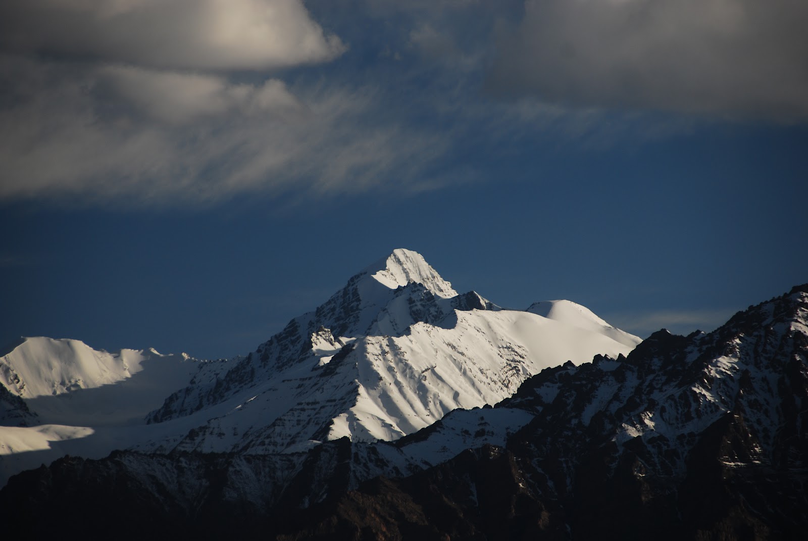
Kang Yatse rising above Nyimaling

Heading up to the Kongmaru La

The impressive striped gorges leading down to Shang Sumdo

From Tachutse, we started to climb in earnest up to the high-altitude pastures of Nyimaling, where we put up our tent and then walked up to the snowline on the impressive glaciated peak of Kang Yatse (6400 metres) which had dominated our views for the previous two days. It’s a very pretty peak, with a skiable face on the west and a dramatic cliff separating the main and subsidiary peaks. The landscape had changed entirely, opening up from the confines of the canyon into vast grasslands that were a relief to the eye. We slept comfortably that night at 4850 metres, and trotted over the final 400 vertical metres in an hour and 45 minutes to the top of the 5250-metre Kongmaru La. The views from the top back down the Markha Valley were epic, with endless layers of steep rock faces overlaying each other all the way to the horizon. We paused for breath, cookies and photos, and then trotted down the much steeper northern face of the pass towards the road at Shang Sumdo. The downhill proved to make for very interesting walking, as we descended steeply into a narrow gorge threaded by a path that sometimes seemed more canyoning than walking, with dozens of stream crossings. Terri rode the horse to keep her feet dry, but I put on my Teva sandals and got wet. We finally emerged onto a new jeep road, had a bite to eat and drink, and were whisked off by jeep back to the sybaritic comforts of Leh: big, soft beds, mango lassis, tandoori chicken and morning pancakes.
Dining well on the trail!  Check out those professional-looking chapatis!
Not that we didn’t eat well on the trail, mind you. We cooked for ourselves, and with the horses there to carry extra weight, we bought a pressure cooker and a chapati skillet and spent many a happy afternoon creating great meals: curried lentils, stews with dumplings, pancakes, omelettes, soups, cups of bouillon, chapattis and much more. We brought along lots of potatoes, onions, carrots, flour, eggs and other heavy, bulky items that, had we been carrying everything on our own backs, we would not have brought. It certainly makes a difference living off delicious real food, rather than instant noodles and dehydrated meals as has been the case in the past. We even brought along a bottle of duty-free Glenfiddich and made a point of having a wee dram (or as they call it in India, a peg; or, thanks to Terri’s Kiwi accent, a “pig” or a “piglet”) in the late afternoon. We tended to go to bed very full of great food, and to have great breakfasts of oatmeal or eggs or pancakes to start the day. Since we had bought food originally for 20 days of trekking, we had ample quantities (or, in the case of oatmeal, grossly over-ample quantities) of most things, and we seemed to eat until we were ready to explode. The strange thing is that, despite the fact that we usually only walked 4 or 5 hours a day, not carrying heavy luggage, and that we ate gluttonously, we seemed to lose weight quite quickly. Altitude, even though we were well acclimatized by the end of the Markha trek, is hard on a metabolism, and produces dramatic weight loss, both of belly fat (good) and of leg muscle (not so very good). I expect to look very skeletal by the end of the summer’s mountaineering!


Argali near Tso Kar

Kiang near the last pass
Our second trek turned out, by coincidence, to be with Tundup and the same horses. This time, for a change of scenery, we opted for a more high-altitude wide-open landscape. Seven years ago, when my sisters and I bicycled through Ladakh, we always regretted that we did not make it to the lovely lakes of Tso Kar and Tso Moriri, so Terri and I decided to put this regret behind. We caught a lift up to the village of Rumtse, met up with Tundup and the four horses, strapped on the luggage (now carried in two nifty tin trunks that Terri bought in order to reduce the chaos involved in packing our food and cooking gear in burlap sacks), and set off uphill. Rumtse, at 4150 metres, is by far the lowest point on the trek, which traverses a series of 5000+ metre passes on its way to the lakes. By now we felt much better at altitude, and walked easily uphill towards the first pass. The second day of the trek we crossed two big passes (5150 and 5230 metres), and I definitely felt the thin air on the second ascent, although I slept well at 5050 metres that night. On the third day, we crossed a third pass at 5300 metres, and then descended towards the beautiful blue patch of Tso Kar lake. On the way down, we scared up a large herd of argali (bighorn sheep) and watched how effortlessly they bounded uphill away from us. Terri watched them thinking “I bet they’d make great eating!”, as her carnivorous instincts overcame her vegetarian trekking diet. As we descended, Tundup told us that we would see “zebras”, and this puzzled us until we saw the first one, and realized that he meant the kiang, or Tibetan wild ass, an equid that bears a striking resemblance, other than colouring, to a zebra. We spent most of the rest of the trek admiring kiang and trying to take pictures of them, difficult as they tended to keep a lot of distance between them and us. 


Newborn foal and mother near Tso Kar
At Tso Kar we celebrated Terri’s birthday by visiting a nearby tourist camp and having a slap-up dinner of Italian food. The next day, as we trudged across the endless windswept plains around Tso Kar, I realized that I had eaten something that disagreed with me, and spent the next 24 hours feeling very sorry for myself, and not appreciating the tremendous views across the plains to the salty shores of the lake and to the high, snowy peaks beyond. We did see lots of kiang, a herd of argali and what Tundup thought was a wolf (it was difficult to see as it was far away and moving quickly). The next day I was better, and thoroughly enjoyed the last 4 days of the trek as we barely saw another human being while walking through endless high-altitude meadows full of horned larks, Tibetan snowfinches, robin accentors, kiang, marmots, pikas and voles. Every valley seemed to present prettier vistas than the last one, and the final pass, at 5450 metres the highest point of the trek, was fantastic, a huge open bowl ringed by 6000-metre peaks on one side, and a steep descent to the vast azure expanse of Tso Moriri on the other.

Contemplating eternity on the shore of Tso Moriri
It was a shock to the system to emerge from this Alpine idyll into the dismal end-of-the-road dump that is Korzog, the only settlement of any size on the shores of Tso Moriri. We gave our tins, cooking pots and leftover food to Tundup in gratitude for his stalwart service over the past two and a half weeks, checked into a tourist camp, bathed and slept and ate disappointingly, and then walked out of town along the shores of the lake to a secluded shaley beach that provided amazing views across the impossible blue of the lake to the riot of pastel colours that made up the opposite shore. We sat there, sketching and writing and trying to absorb the beauty and sublime setting, conscious that our trekking days had come to an end.

The jeep ride back to Leh, like all experiences in a vehicle in India, was more to be survived than enjoyed, although we figured out where all the nomads of southeastern Ladakh were while we were trekking through empty grasslands. They were grazing their flocks along the jeep road, looking very picturesque as they moved camp, yaks carrying their tents, hundreds of sheep grazing along slowly, and the nomad families themselves riding their horses. We dropped eventually down to the Indus and drove recklessly and dangerously along the road back to Leh. A day of complete sloth in Leh, and it was time for a flight here to the hellfires of a Delhi summer.

The view across Tso Moriri
Overall, the month in India has been a tremendous experience, for my seeing new areas (Lamayuru, Markha and Tso Moriri were all new places for me), acclimatizing for Peak Lenin and Muztagh Ata (my primary objectives for the rest of the summer) and for spending wonderfully fun, companionable time in nature with Terri, seeing wonderful animals and birds, eating well and getting into shape after the laziness and middle-aged spread of this past school year. I don’t know when or if I’ll be back to India again, but if this is adieu, it’s been a great send-off.


Tuesday, June 12, 2012

Back on the Roof of the World

Leh, Tuesday June 12

Up at the Shanti Stupa overlooking Leh
I am back in Leh, the capital of the northernmost bit of India (Ladakh) for the first time in 7 years.  In 2005 my sisters and I cycled from Manali to Leh, around a few of the scenic bits of Ladakh and then out to Srinagar.  This time I'm here with Terri, hiking instead of biking.

Or, rather, trying to hike.  We've been here in Ladakh for 4 days trying to arrange some long-distance treks back across the Himalayas, but until today, we've had no luck.  But let's start at the beginning of the story.

Another year of teaching came to a halt just over a week ago, and I left for Geneva airport the morning after our staff end-of-year dinner, having been up most of the night packing up my apartment for the summer.  I headed to the airport laden down with my backpack, full of hiking gear, and my ski bag, full of mountaineering gear for the second part of the summer vacation.  A long flight to Delhi, a long nap, and I was ready to face India for the fourth time.  Delhi was its usual steaming, polluted self, but I found a decent hotel in the tourist slum of Paharganj (the inelegantly named Hari Piorko, hereafter known as the Hairy Porko), with quiet rooms, comfy beds and (best of all) an aquarium set into the wall of every room.

A shikara on Nageen Lake, Srinagar
Terri and I being paddled across the lake on a shikara

Terri flew in from Bali that evening, and the next morning found us at Delhi airport again, boarding a Kingfisher Airlines flight for Srinagar.  It seems ironic that on an airplane owned by a brewery, they don't serve alcohol.  We flew through heavy pre-monsoon turbulence and landed in a howling gale.  I managed to find our way back to the same part of Nageen Lake that Audie, Saakje and I stayed on in 2005, and we settled in for 2 wonderfully relaxing nights on a houseboat.  It was easy to sit at the stern, reading or sketching the elegant shikara boats being paddled by, watching kingfishers and moorhens on the water, and gazing across the lake to the old Mughal fort topping a nearby hill.

A 2000-year-old Kushan Buddha near Mulbekh
All good things must come to an end, and our brief stay in Srinagar was followed by a 2-day marathon of discomfort as we bumped and ground our way to Leh in a hideously uncomfortable jeep.  The weather was poor, with rain on the Zoji La (the pass across the actual Himalaya range) and clouds and showers the rest of the way.  The Indian government is pouring lots of effort and money into paving the entire Srinagar-Leh road, but so far the main effects have been a lot of piles of sand and rock being pushed around lethargically by emaciated Bihari road workers, inbetween bouts of staring vacantly into the middle distance.  The road is full of diesel-belching trucks as it was in 2005, but a new feature is the hordes of middle-class Indian tourists from the plains riding the road on motorcycles.  It was nice to stop off and see the ancient Kushan-era Buddha carved into a rock face at Mulbekh, but the best part of the trip was the fact that it finally ended in Leh.  It was far more fun, stimulating, engaging and comfortable to cycle this road than to bounce along its potholes in a vehicle.  

Stok Kangri, the tallest peak near Leh; I climbed it in 2005                                           The Zanskar Range seen from Leh
It was strange to be back in Leh, having spent quite a lot of time there in 2005.  Most of the restaurants and guesthouses are the same, but it's taken me a few days to dig my memories of them out of the archives.  The setting of Leh is stunning, and looks more impressive this year since it's earlier in the summer, resulting in much, much more snow on the surrounding mountains.  Leh sits above the north bank of the Indus, with 5700-metre mountains to the north (the Ladakh Range) and 6000-metre mountains to the south (the Zanskar Range).  On a clear day (and there have been few of those so far), the views from a high vantage point like the Shanti Stupa are stunning.  

Terri spinning the prayer wheels at Lamayuru Monastery
The reason for this trip back to Ladakh is to do some trekking; in 2005 there wasn't much opportunity for that, as we had the bicycles, so we thought that this year we'd be free and easy and would walk all the way back nearly to Manali.  Little did we reckon on how difficult it would be to find horsemen and donkeymen willing to rent out their animals' services to carry our food.  We have had to abandon our ambitious initial trek (from Hemis to Darcha), and even the old fall-back from Lamayuru to Darcha foundered because there were no equids to be had in Lamayuru.  Lamayuru itself is a pleasant enough village, with a wonderful monastery and lovely surroundings, but it was frustrating not to have any luck in finding four-legged transport.  
A chukar partridge; the hillsides teem with them


We've finally pared down our ambitions to a tame 8-day walk up the Markha Valley, and have convinced a horseman to rent us no fewer than 4 horses (!) to carry our gear for us.  We leave tomorrow, and not a day too soon; 4 days of kicking our heels here in Leh and in lovely Lamayuru was too long!

So off we go tomorrow, hoping for less rain and snow, and for the passes to be clear of snow.  I'll keep you posted on developments!


Saturday, June 26, 2010

Bhutan Retrospective (April 2008)--Land of the Thunder Dragon

Thunder Bay, June 25
I can’t believe that more than two years after visiting Bhutan, one of the least-visited countries in the world, an exotic Himalayan kingdom that had been on my radar screen for over a decade, I still haven’t written anything about the unforgettable ten days I spent there in April, 2008 with Joanne, during the spring Thingyan (Buddhist New Year water festival) break from teaching in Yangon. Now that I have some time on my hands and some inspiration (why have I been so tired for the past two months?), it’s time to remedy that omission.
The two things that most people know about Bhutan, surely one of the world’s more obscure countries, are that it costs $200 a day (minimum) to visit, and that its far-sighted king Jigme Wangchuk has chosen an unorthodox model of development that includes the idea of Gross National Happiness, rather than Gross National Product, as being the best way to measure the well-being of a country. I knew a little more before we went, such as the fact that Bhutan, in stark contrast to many other Himalayan countries, has done an exceptional job of maintaining forest cover, and the fact that there has been an exodus of Nepali-speaking people from Bhutan over the past twenty years to refugee camps in southeastern Nepal, as a result either of Bhutanese discrimination (the refugee’s version of events) or of a crackdown on illegal immigration (the Bhutanese government’s version). However, I still didn’t know much, and I was eager to see what the country looked like as a result of following its own path to development.
Once you accept that visiting Bhutan is going to be expensive (that $200 figure is accurate, with a possible discount down to $160 a day during the monsoon season), it’s pretty straightforward to arrange a visit. Although visitor numbers were kept low for years, the government is now pushing for an increase, and essentially anyone willing to stump up the necessary cash is welcome to come and visit. Joanne and I Googled tour operators in Bhutan, found a few who wrote back quickly, and chose the one that sounded most promising. The nice thing about having to pay so much money is that we got to write our own tour, picking the places that sounded most interesting, and even arranging to split up for three days to do different things (a remote festival for Joanne to photograph while I went hiking). It hurt to part with so much money, but I figured I’d never be so close to Bhutan again with enough cash in my pocket, so I winced and signed up.
Our flight from Yangon to Bangkok was on the slightly dodgy airline Myanmar Airlines International. The aircraft was actually painted in the colours of Bhutan’s Druk Air, with only a tiny MAI logo above the door to show that MAI sometimes leased the plane. We flew in at 9 pm and scooted to a nearby cheap hotel for a few hours of rest. At the truly hideous hour of 2 am, we woke up again and headed back to the airport. To our amazement, the check-in desk at Druk Airways, the Bhutanese national carrier, had a very long lineup, mostly of Indians on shopping trips. Bleary-eyed, we checked in after a long, sleepy hour of waiting and made our way out to the very same plane we had disembarked from 7 hours earlier. Too bad we couldn’t have just slept on the plane overnight!
We flew to Calcutta first, where the Indian shoppers were exchanged for more Western tourists. The approach into Paro airport was as dramatic as we had heard, with the airplane banking in through a deep valley, rather like Luke Skywalker flying in to attack the Death Star. We deplaned onto the tarmac and stood blinking in the sunlight, before taking a few pictures of ourselves with the airplane. The terminal building, like all structures in Bhutan, has to adhere to traditional architectural styles, which meant that the arrival hall, both inside and out, was a rare counterexample to Douglas Adams’ remark that no language on earth contains the expression “as beautiful as an airport”. We were one of the last pairs of tourists to make our way through the immigration queue, where our visas were stuck into our passports and where we met the man who would be our guide for the duration of our visit, Ghalley.
We spent much of the day poking about the town of Paro, and driving (nearly two hours) from Paro to the capital, Thimphu, surely one of the least-known capital cities in the world. All the way Joanne and I had our noses pressed to the glass, trying to see as much as possible and see how reality matched up to the Shangri La tourist brochure image of The Land of the Thunder Dragon.
Paro boasts an impressive dzong, the first of many of the solid, rectangular forts that we would encounter throughout the country. The walls are massively solid, sloping inwards like Lhasa’s Potala, painted white and ochre, while the gently sloping roofs look almost Chinese except for the small gilded spires. Carved wooden balconies hang below some of the upper-floor windows. Photographing it, on the banks of a rushing Himalayan river, with men and women in traditional dress crossing an old prayer-flag-draped suspension bridge in front of it, I felt that I really was in a country with its own rich historical traditions. The dzong, like much of Bhutan’s architecture and religion, is very similar to what you see across the Himalayas in Tibet; the Bhutanese, like the Sherpas in Nepal and other cultures in the Indian Himalayas, are a Tibetan people ethnically, linguistically and religiously. In fact the English word Tibet is said to be a corruption of Bhot, which is also the root of the name Bhutan. The people look quite Tibetan in their features, although with an admixture of the Indian subcontinent in them; looking at my Bhutan photos, the faces almost look Burmese at times.
As we drove around, we noticed that not everyone was wearing the traditional dress (kiri for the women, gho for the men), and Ghalley explained that to work in the tourism or government sectors, or to visit a government office, traditional dress had to be worn, but otherwise it was optional. We saw a number of young people dressed in jeans and leather jackets in downtown Thimphu, trying to look vaguely rebellious. The gho is best described as a checked knee-length dressing gown, worn with knee socks and shirts with huge white cuffs that fold over the sleeves of the gown. The women’s kiri is a floor-length wrap-around skirt, like a Burmese woman’s tamein, worn with a short jacket above.
The country looks relatively clean and extremely uncrowded by the standards of the region; with only 700,000 inhabitants (compared to 27 million in Nepal), Bhutan is a relative minnow. We saw quite a few cars, many of them quite new, and well-paved roads, and the general look was more prosperous than Nepal or rural India. We were told that a typical government office job pays about $250 a month, far above the average in the Indian subcontinent. In fact, when we drove by a road construction project, we saw Bihari labourers from India breaking rocks; Bhutan imports them since Bhutanese are apparently not crazy about doing menial work for low wages.
The landscape was pretty vertical, with fairly steep-sided valleys carved out of high mountains. The reason why the airport is so far from Thimphu is that Paro is one of the very few places with enough flat land for aircraft to land. Bhutan, unlike Nepal, has almost no low-lying plains; the boundary with British India was drawn at the foot of the hills. This explains a large part of why Nepal is so much more densely populated than Bhutan. There certainly was tree cover, but much of the landscape looked much drier and rockier than I had anticipated, far from the lush forests of central Nepal.
One of the quirks of Bhutan is that the import and sale of tobacco is forbidden. Prohibition being as ineffective as it is, there is apparently a thriving trade in black-market cigarettes from India, but I didn’t see anyone lighting up openly. I did see a man with a furtive, unlit cigarette cupped in his hand in a building in Paro, while there was a definite whiff of tobacco smoke in the Thimphu post office. Given the tremendous health burden that smoking puts on a country, the prohibition seems like a good idea, making Bhutan one of the only countries that has decided that health benefits should trump tax revenues.
As we drove around, one of Bhutan’s most distinctive idiosyncrasies was everywhere to be seen. Phallic imagery, held to be useful in driving away evil spirits, was unmissable: painted on white-washed walls wrapped in dainty ribbons, standing out proudly from doorframes above yak skulls, or dangling in outsized carved wooden form from the eaves of houses and monasteries, phalli were everywhere. The Bhutanese seem to be as obsessed with the erect male member as were the ancient Greeks and Romans!
The traditional architecture that had so charmed us at the airport and at Paro dzong was everywhere in evidence. It worked on houses, generally constructed out of adobe and timber, but on modern concrete blocks, the paint job did little to hide the essentially modern and ugly nature of the buildings. On the other hand Thimphu looks a lot nicer than most cities of its (small) size in the developing world, so maybe the slightly fake paint job is better than the alternative. Thimphu is a fairly modern creation, a bit like Bhutan itself; the first king of Bhutan, the current king’s great-grandfather, only took the throne in the early 20th century, and Thimphu became the capital even later, in the 1960s. It sprawls slightly across the valley floor and a short distance up the pine-clad slopes of the Himalayan foothills, looking like a cross between a Japanese provincial town and a very small, very clean version of Kathmandu.
We drove around the town briefly, passing crowds of citizens paying their respects to the new government ministers appointed since the country’s first-ever democratic elections, held just two weeks earlier. The men wore ceremonial white scarves draped over one shoulder like small togas; we were told that a man’s rank could be read from the colour of his scarf, and these white scarves were the badge of the common people, while yellow, red, green and blue showed various grades of nobility and royalty. We also were passed by the king’s car, which was accompanied by one of the smallest official motorcades in all of Asia.
The rest of the day passed in a long nap, supper and a good night’s sleep. Supper was a delicious confection of cheese and chillies that Joanne liked so much that she tried to get it served at every subsequent meal. We awoke the next day refreshed, ready for a day of poking around the capital. We began the day by walking out of our little hotel and staking out a spot on a bridge over the river for taking pictures of people. We were fortunate in our choice of location, with crowds of schoolkids crossing the bridge to get to school, and hundreds of farmers and city-dwellers headed to and from the market and bus depot, making for a good cross-section of the population. The students all had to wear uniforms based on traditional dress, albeit accessorized with stylish sneakers and knapsacks. A few monks, dressed in the same Burgundy colours as in Tibet and Burma, stood out in the sea of kiris and ghos worn by the adults. Wizened old faces of bow-legged farmers contrasted with the porcelain doll complexions of stylish young women from the city.
After breakfast, Ghalley arrived to take us off on our city tour. We covered an amazing amount of ground in a single day, visiting no fewer than eight different sights. We started off at the thaksin reserve, where the national animal, looking like a cross between a deer, a goat and a bison, wanders around a fenced-in enclosure in the hills above town. The king decided some time ago that it was un-Buddhist to keep a wild animal in captivity and ordered the reserve closed down, but the thaksin kept wandering back to their old enclosures, so it was decided to keep it open to help out these animals who had become accustomed to the free handout. We kept driving steeply uphill to the end of the road at a telecom tower, where thousands of multi-coloured prayer flags hung in crazy profusion from every branch of every tree. After absorbing the vast views over Thimphu and the mountains beyond, it was back down the hill to a small nunnery (populated by some of the least motivated nuns I have ever seen but visited by some wonderful old female pilgrims) and then a school teaching the traditional arts of the country. The students seemed about as absorbed by their chosen arts as the nuns had been, with the only signs of animation in the courtyard during tea break as boys and girls flirted and exchanged mobile phone numbers. Some of the Buddhist thangkas and murals and sculptures showed promise, but overall the quality of workmanship was underwhelming. However, it was good to see that the government is trying to keep traditional arts alive as the country modernizes.
The weekend market, our last stop before lunch, was much more rewarding, at least in terms of local colour. Every second stand seemed to be selling hot chilli peppers, and the women could easily have been from Burma’s Shan State with their weather-beaten friendly faces and brightly patterned kiris. There was a great variety in facial types, with some classic Mongolian and Tibetan features and others looking as though they had stepped off the streets of Calcutta.
At lunch we handed over our bundle of $100 bills to the owner of our tour agency to pay for our tour, and had an interesting chat with him. He said that the former king, Jigme Wangchuk, the architect of Bhutan’s modernization, had watched the self-destructive demise of the Nepalese monarchy and decided that the Bhutanese system of government was going to have to change from a benevolent absolute monarchy to a limited constitutional monarchy with an elected parliament. Even though most Bhutanese probably would have preferred the king to remain in office and continue to hold the reins of power, he decided that one way to avoid the sort of nepotistic corruption that blighted Nepal was for him to abdicate in favour of his son, thus eliminating the power base for the families of his three wives which were widely perceived as becoming too wealthy and powerful for the good of the nation. The elections which had just occurred were another step along the path to developing a modern state; the party which had won a surprisingly large majority was viewed as being opposed to the royal ex-inlaws.
We headed out, sated with momos, and made a brief drive-by visit to a memorial gompa to the third king (the current king’s grandfather) before heading to the day’s photographic highlight, Changantha Lhakhang, a small, brightly coloured monastery full of painted prayer wheels and dedicated pilgrims. Joanne had me working as a photographer’s assistant, spinning prayer wheels to get just the right effect. As we left, we met another family of pilgrims with about eight teeth between them, and Joanne managed to get them to pose for her with the mountains and the monastery in the background. We finished our tour at Trashicho Dzong, the king’s official residence and palace. It was huge and imposing and almost completely empty, although at the end of our visit, the king drove by and there was a flurry of activity of soldiers and officials keeping the few tourists motionless and out of the way.
Cities are all very well, but a Himalayan kingdom’s highlights are, by their nature, outdoors. We had chosen to walk up to the isolated Gasa hot spring east of Thimphu to begin our whirlwind tour of the countryside. Joanne absolutely loves hot springs, and I have to admit that after a day of hiking or skiing, there’s nothing that feels better than a good soak. We drove out of town for three hours, crossing a 3050-metre pass, the Decho La, which was completely swathed in dense fog. Ghostly cedar trees peeked through here and there, adorned with thousands of strings of Buddhist prayer flags; our driver and Ghalley helped Joanne add our contribution to the fluttering colourful tangle. A memorial gompa commemorated modern Bhutan’s only war, a brief fight in 2003 against Indian rebels sheltering in the south of the country.
Our road descended into another steep-sided valley, and then passed through the town of Punakha and then headed uphill along a dirt track in ever-increasing states of deterioration. After a series of dramatic, erratic switchbacks, we tumbled out of our vehicle in a tiny hamlet at an elevation of 2300 metres. Our outsized caravan was slowly assembled: two cooks, a muleteer and his assistant, our driver, Ghalley, five mules and enough food for a battalion for a week. Joanne, worried that she wouldn’t be able to make it three hours up the valley to the hot springs, had opted for her own mule, and we set off with me strolling alongside her as she perched a bit precariously on her saddle. On the steeper downhills, as we crossed small streams, the mule owner had her get off and walk, and sometimes she would forget to climb back aboard, meaning that she still limped into the hot springs with a sore knee and ankle.
The walk was wonderful, passing through dense rhododendron forests punctuated with bamboo stands and waterfalls and alive with dozens of species of birds. It reminded me strangely of the highlands around Nikko that we visited many times during our stay in Japan. I wandered along happily, looking for birds in the dense undergrowth and absorbing the surroundings. The skies, leaden at first, began to drop drizzle as we progressed, and when we finally got to the hot springs, the rain settled in for a prolonged fall. Our entourage set up our tent, and we wandered out for a soak in the tubs, not terribly crowded at this point in the afternoon. There are few things as enjoyable as soaking in hot water while cold rain or snow pelts down on you. As far as atmosphere and cleanliness go, the pools finished a poor second to any Japanese onsen, but it was fun to see the local Bhutanese enjoying themselves, as they gathered in increasing numbers as dusk approached. After a delicious meal in our cook tent, Joanne and I wandered out for another soak, this time barely finding space in any of the pools. At least the rain let up, so that our night sleeping in our tent wasn’t too soggy.
After bathing one more time in the early morning in a failed attempt to beat the crowds, we retraced our steps to the car, spotting more birds (red-vented bulbuls, whistling thrushes, grey-headed flycatchers and a host of unidentified species). The ground was richly carpeted with exquisite wildflowers. For one of the first times in our visit, the grey skies parted and we had views of distant Himalayan giants, as well as an imposing dzong looming above the dense forests on a distant ridge. Joanne’s mule was behaving mulishly, and I burned some calories whacking it across its backside with my walking stick trying to get it to move. It took nearly four hours to get back to the car, and after a picnic on the richly dunged grass beside the road, we swayed down the rollercoaster road back to the pavement, and drove onwards to the town of Punakha, site of an impressive dzong. There was a large population of monks, many of them young novices, and Joanne and I took lots of photos of them as they clowned around boyishly in their free time. The walls were adorned with exquisitely painted mandalas, and the prayer hall was a thing of beauty. Ghalley gave us a really informative talk about the symbolism of the Six Realms mandala, which had three animals representing the deadly sins of lust (a rooster), hatred (a snake) and ignorance (a pig). We headed up the hill to our lodge, a pretty cluster of cottages that seemed like a piece of Shimla or Darjeeling plunked down in Bhutan. The hotel was full of a group of wealthy bird-watchers, and the gardens were alive with dozens of species. Like all the Himalayan countries, Bhutan is an ornithologist’s dream. Our lodge was perhaps the nicest hotel of the trip, and we slept long and deeply.
The next day Joanne’s new guide and driver arrived, and we drove together towards the east before we split up. Joanne and her guide headed further east towards a festival, while Ghalley and I turned off southwards on a lightning trip to the marshy highland valley of Phobjika. During the winter there is a resident population of extremely rare black-necked cranes, but we there in the wrong season, and so we had to make do with the scenery and a visit to the crane conservation centre. Amazingly, even in sparsely-populated country like Bhutan, conservation efforts for rare species can be difficult because of human population pressure and habitat destruction because of farming, as is the case here. Luckily the king, and his father before him, are quite keen conservationists, as befits devout Buddhists. The dramatic scenery on the pass into the valley made up for the lack of cranes, as did the flowering rhododendrons in the dense forest. Joanne and I said goodbye in the junction town of Wangdus Phodruk and I headed back to Thimphu, daydreaming most of the way through persistent drizzle and greyness.
After a good night’s sleep, Ghalley and I drove back up to the telegraph tower above Thimphu where we met up with our trekking team. Again, the number of people and mules involved in going on a three-day trek was excessive; I was employing 5 men and 7 mules. I thought of multi-day treks I had done elsewhere in which I had carried everything I needed on my own back. We set off ahead of the horses, as the cooks had to wait for forgotten equipment to be brought up from the office in Thimphu. It was a relief to be walking essentially on my own, under my own power and at my own pace, the only way to see and appreciate the Himalayas. We walked under leaden skies that spit rain periodically, through moss-covered primeval forests of cedar and rhododendron alive with myriad birds, some of them completely new to me. A couple of hours of steep, steady ascent brought us to Phajo Ding Gompa, a small, remote monastery at 3400 metres that clings to the slopes like the popular image of Shangri La. We waited in the cold for an hour and a half for the horses to catch up with the all-important lunch, and had time to discover that the monastery looked a lot better from a distance. The young novices were fun to watch, though, as they played soccer and a form of bocci in the fields behind the monastery.
Mist-shrouded mountains
With monasteries atop
Himalayan high
Rainbow-framed Thimphu
Shimmers a mile below me:
A good morning’s hike
After our long-delayed lunch, I climbed ahead quickly, stomping up over the vertiginous 3850-metre pass behind the monastery, then settling down in the mist to take pictures and wait for the horses. I felt intensely alive, as I always do walking in the mountains, concentrating on the views and the wildlife, measuring my body against the unforgiving test of the vertical landscape. Once across the pass, the landscape changed entirely to a high-alpine moorland, with the rhododendrons shrinking to dwarfish shrubs. We picked our way along crumbling, rocky ridges, across marshes and along exposed hillsides. The earlier rain turned to occasional snow flurries, but my thermometer never dipped below freezing and walking kept me warm. On our way through one small meadow, we scared up a male and female monal pheasant. They exploded up off the ground, wings beating noisily, then swooped downhill in a flash of iridescent blue and green feathers. I felt lucky to have spotted them, and my good mood continued all through the afternoon’s walk under increasingly sunny skies until we set up camp just above a marshy meadow called Semkhota at 4000 metres. I felt like some early European explorer, sitting on my camp chair writing up my diary as the various staff set up tents, fired up stoves and began plying me with tea, soup and food. I sat writing up my diary and watching birds, completely at peace with the world, until a sumptuous feast appeared (as well it might, given how much food we were carrying!)
After a restless altitude-affected night in the tent, the next day was easy, surprisingly so since I had been warned that trying to walk from Thimphu to Paro in three days was pushing the limits of what could be done. Instead, after less than four hours of actual walking, we set up camp in the early afternoon. I wandered along happily all day along a ridge, past a series of small alpine lakes, overjoyed to be footloose in the mountains. We saw another female monal pheasant, and later watched a small falcon catch a hapless rosefinch in mid-air. The dwarf rhododendrons were alive with several species of rosefinches, the vibrant scarlet of the males standing out against the green of the shrubs. We eventually dropped off the ridge, plummeting 600 vertical metres to cross a river, then climbing half as far up to a sunny ridge full of yak pastures, where we lunched at noon looking south at a magnificent panorama of snow-capped peaks. After lunch, it was less than an hour’s easy stroll to our campsite, in another yak pasture called Jangchulhaka at 3600 metres’ elevation. I sat outside in the sunshine writing, watching rosefinches, sketching and reading, at complete peace with the world.
The final day of walking was again shorter and easier than I had expected. I slept well, awoke early, breakfasted handsomely and then sat at a lookout atop a hill behind the camp, taking photos of the high peaks to the northwest which had made a rare cameo appearance from behind their constant veil of clouds. The forest was alive with birds, including some beautiful black and yellow grosbeaks. Ghalley eventually summoned me and we dropped off our ridge through thick rhododendron forests, along a lower ridge to a tiny, picturesque dzong and finally down, down, down endlessly to Paro. The relentless rhythm of my footsteps as we headed downhill got into my head and I found myself composing songs in my head to the beat.
After a relaxed trailside picnic, we were down at our car before 2 o’clock. We drove down into Paro town and found our hotel tucked into the farm fields beyond, where Joanne arrived a few hours later. She was full of excitement from her drive out to the festival, and had a camera card full of great pictures of dancers, monks and local farmers with their weather-beaten faces and kindly expressions. After dinner, we amused ourselves trying to take pictures of Paro Dzong, lit up at night and dominating the skyline.
Our last full day in Bhutan was spent walking up to one of the undoubted highlights of the country, a key feature of any tourist itinerary, Taktsgang Gompa. Also known as the Tiger’s Nest, it hangs improbably from a seemingly inaccessible cliff face in the mountains just above Paro. We set off early, and by 8:30 we were at the parking lot below, where Joanne was loaded onto a mule that seemed more lively than her mount at Gasa. I set off on foot, keen to see whether I could beat her to the top. It was no contest; I sat at the top for a quarter of an hour waiting for her to arrive, staring across at the incredible piece of architecture that is Takstgang. There were quite a few Western tourists, but they were outnumbered by Bhutanese pilgrims. I noticed that with very few exceptions, the Westerners rode mules up, while the Bhutanese walked. This may have something to do with the fact that the Westerners outweighed the Bhutanese by an average of 40 kilograms, little of that muscle.
When Joanne arrived, we walked down a steep slope to a waterfall and bridge that gave access to the final stairway to the monastery. The buildings, whitewashed with ochre and gold highlights on the upper stories, seem to sprout organically from the rocks, clinging to the cliffs like moss. It’s an incredible feat of engineering, ascribed in myth to a famous Tibetan figure, the 8th-century spreader of Buddhism throughout the Himalayas, Guru Rinpoche, who’s supposed to have flown here on the back of a tiger. It was destroyed in an electrical fire in 1998 and only reopened a few years ago, after an expensive rebuilding.
It was at this point that I made an unfortunate split-second decision that coloured the rest of the day. At the entrance to the complex, visitors are required to leave bags, as the authorities are concerned both about backpacks banging into wall paintings and with various pieces of art disappearing into the private collections of tourists. I took my camera with me (even though we weren’t allowed to take pictures inside, I wasn’t going to leave it sitting at the entrance), but in a moment of inattention I left my fancy trekking watch, with its altimeter, compass and thermometer, attached to the outside of my camera bag in the pile of tourist backpacks.
The inside of the monastery is impressive, everything you expect a Tibetan Buddhist temple to be: dark, mysterious, full of statues and colourful mandala paintings, redolent of yak butter. We wandered around happily absorbing atmosphere, finally emerging to find my watch, predictably, gone. I was outraged; the bag had been left in an area overseen by a surly Bhutanese soldier who was completely unconcerned about the theft. This did nothing to endear him to me, and his abrupt, dismissive answers soon had me yelling at him. I was certain that the soldier was either inattentive and incompetent, or else had actually stolen the watch himself. It was foolish of me to have left the watch on display rather than attaching it to my wrist, but I had been lulled by the fact that we were in a Buddhist haven of Gross National Happiness, and at a place of worship and pilgrimage. I hate having things stolen, especially something that was a cherished gift from Joanne, and I vented my annoyance on the sneering soldier before stomping off back down the mountain. Checking the rest of our possessions, Joanne found that one of her two bags had been opened, although nothing had been taken. Presumably the thief had been interrupted by tourists arriving; this was just as well, as in Joanne’s other bag there was a purse full of dollars that would have been a far more valuable prize.
The rest of the day followed unpleasantly, with telephone calls, complaints to the police, and a summons to the office of an arrogant army major who, in classic bully style, tried to shift the blame onto the hapless and blameless Ghalley. I was having none of it, but as an outsider I was able to ignore the blusterings of the officer without worrying about the consequences; Ghalley left worried that somehow he was going to end up getting blamed by the army for the theft, when in fact he was about the only person who couldn’t have stolen the watch.
The theft left a pall over that last day, although stumbling across an archery competition on our way back to our hotel redeemed the day partly. Bhutan’s national sport is archery, and the only Olympic medal ever won by the country’s athletes came from a female archer. Driving through town, we spotted a cluster of people holding bows and Joanne insisted that we drive over to watch. The men wore traditional ghos with a series of blue, green, red and yellow scarves handing from their belts, but their bows were expensive modern composite competition models. Their precision was impressive, especially given the enormous distances over which they were shooting (well over 100 metres). A reasonable crowd had gathered to watch and cheered each shot with genuine enthusiasm. Joanne and I tried to capture the moment of release with our cameras, but I found it an almost hopeless task. Joanne was much better at freezing the arrows as they left the bowstrings. It was a nice bonus to see the archery, as we had hoped to see a competition in Thimphu but hadn’t been in town on the proper day. Walking back to the car, we were amused to realize that we were walking through knee-deep patches of wild cannabis, which the Bhutanese call "pig grass". I wonder if they have chilled-out pigs with goofy grins and ridiculous appetites?
That evening we dined well, slept long and deep, and drove to Paro airport the next morning. Despite the expensive, tedious annoyance of the stolen watch, I was very impressed overall with Bhutan overall. Its scenery is impressive, it is doing extremely well at preserving its fragile Himalayan environment, its economic development seems to be far more equitable and well-thought-out than in India or Bangladesh or Nepal, and its culture seems to be standing up well to the tsunami of creeping global uniformity overwhelming other countries in Asia. Even its politics seem to be headed along the right path. Given unlimited time and money, I would gladly go back to Bhutan and spend a couple of weeks trekking across the high passes and mountains of the extreme north of the country. If I had the chance to teach or work there in some capacity, I would go there in an instant; a better country for hiking, biking, photography, bird-watching and immersing oneself in a fascinating culture would be hard to imagine.
As we flew back towards Bangkok and our connecting flight to Yangon, both Joanne and I agreed that our visit to the Land of the Thunder Dragon had been one of the highlights of our time in Burma, and were glad that we had paid the money for the privilege of seeing one of the most interesting countries in all of Asia. Country number 72 on my lifetime list gets special billing as one of my favourite destinations so far.