Karakol, Kyrgyzstan, July 20
 |
| The huge bulk of Pik Pobedy (on the left) and its subsidiary summits, seen from Dikiy Camp |
It's a lazy day off in Karakol, allowing our bruised bodies and tired muscles to recover after a surprisingly tough trek along the Inylchek Glacier, so it's a good chance for me to bring you, my dear readers, an update on our travels.
Inylchek: Two Decades of Anticipation
The Inylchek Glacier has been on my mental radar for more than twenty years. In 1997 I spent two weeks trekking along the Baltoro Glacier in the Northern Areas of Pakistan. The Baltoro is said to be the longest glacier on earth outside the Polar regions, with the Inylchek touted variously as the second- or third-longest. I thoroughly enjoyed the Baltoro trek, seeing K2, Broad Peak and Gasherbrum I and II, four of the world's 14 8000-metre mountains, so I immediately started thinking about one day walking up the Inylchek to see two of the five Snow Leopard peaks, the mountains higher than 7000 metres located within the former USSR (all within or on the borders of Tajikistan, Kyrgyzstan and Kazakhstan). I had hoped to visit the Inylchek in 2004, while cycling through Kyrgyzstan, and then again in 2012, when I was in the country to try to climb Pik Lenina, but on both occasions I had been frustrated by a combination of weather and a shortage of time. When Terri and I decided to visit Kyrgyzstan this summer, hiking along the Inylchek was always planned as the centrepiece of the trip.
It was hard to figure out how to arrange the logistics of the trek. My instinct is always to try to do everything independently and on the cheap, but carrying eight days worth of food, plus tents and other camping gear over a rugged, rocky glacial moraine sounded pretty hard. Plus it seemed to make sense to catch a helicopter flight out of the South Inylchek Base Camp at the end of the trek, rather than turning around and walking back again. In the end, we ended up signing up with Ak Sai Travel, a big tour company here in Kyrgyzstan who run a string of tented camps along the length of the South Inylchek Glacier for two months every summer. It was far more expensive to hire the services of a guide, so we opted to do the trek unguided, sleeping in the camps and getting a jeep ride to the start of the trek and a helicopter ride back at the end. It took a couple of weeks to get the annoying border zone permit that we required; we really should have obtained the permit ahead of time through Visit Karakol, the very helpful tour company here in Karakol whose services we ended up using anyway.
Low-Altitude Lassitude
After the end of our previous trek, we had a long stretch (five days) of relaxing in Karakol. We had originally anticipated four days off, but our Inylchek Glacier trek was delayed a day by a combination of landslides, unexploded munitions and a manhunt for a murderer/kidnapper. We had originally planned to go for a couple of days to Bokonbaevo for some petroglyphs and horse riding, but we were put off by forecasts of torrential rain (which didn't transpire). Terri and I did get out to see one of my most cherished places in Karakol from my 2004 visit, the wonderful Przhevalsky Museum (a monument to the Russian explorer and geographer Nikolai Przhevalsky, one of my favourite figures from the history of 19th century Central Asian exploration), the Sunday-morning Karakol livestock market and the 19th-century wooden Russian Orthodox Church of the Holy Trinity. Mainly, though, we lingered long over the excellent breakfast buffet at the Madanur Hotel, took afternoon naps, read a lot of books and felt generally tired and listless. It was a bit like the various sorts of "lassitude" that afflicted the mountaineers in W. E. Bowman's classic spoof of mountain climbing literature, The Ascent of Rum Doodle. Maybe our bodies needed it after 3 weeks of almost non-stop trekking.
Day One: July 10 (To Karkara)
Finally, our waiting came to an end. The road to Inylchek village was still closed, so Ak Sai had decided to load us on one of their regular helicopter flights to supply the camps along the Inylchek. We were picked up in Karakol and driven a couple of hours to the north and east, towards the Kyrgyz-Kazakh border. I had cycled through here in 2004, camping next to one of the Scythian royal burial mounds that dot the high-altitude plateau, and pleasant memories came flooding back as we zipped along the rutted dirt road, past more beehives than I had ever seen in one place. We passed through a border-zone checkpoint, showed our all-important travel permits, turned right and, after a few kilometres, pulled up at Ak Sai's Karkara Base Camp. We checked in, dropped our backpacks in our big yellow Red Fox barrel tents, had a delicious lunch and set off for a stroll to stretch our legs.
The area is beautiful. The Karkara camp is located on a small river that forms the border with Kazakhstan, and we walked upstream, past summer pastures and slightly scruffy livestock enclosures, into a beautiful gorge, along which a handful of Kyrgyz families had pitched tents for a few days' vacation from the cities. We walked along, stopping to chat to a Dutch couple and a British mountaineering team, until gathering dark clouds behind us sent us scurrying back downstream. The rain arrived before the camp, and we were fairly soggy by the time we get back to the tents. Another spread of delicious food awaited us in the dining tent, and we tucked in eagerly before retiring to the tents for a sound night's sleep.
Day Two: July 11, Karkara-Iva Camp (2900 m)
 We were up early with the sun, and, after packing up our sleeping bags, we went to breakfast. We were on the morning's second chopper run, leaving at 10:00. We loaded our baggage and ourselves onto a set of airport scales, then sat around with more tea and coffee until we got the signal to walk out to the helipad. The white Russian helicopter was sitting there being loaded, mostly with expedition gear and Russian climbers who were planning to try to summit Pik Pobedy, or Victory Peak, at 7439 metres the second-highest peak in the former USSR after Tajikistan's Pik Kommunisma. It has a reputation for danger and difficulty, and I didn't envy them at all as they loaded barrels and tin boxes of supplies into the belly of the aircraft. Terri and I were loaded in last, as we would be the first ones out, and then, right on time, we shuddered into the air and started flying southeast.
  Almost immediately, in the distance, we could spot the huge white mass of the Central Tien Shan, the mountain range that runs from China into Kyrgyzstan. Khan Tengri and Pik Pobedy towered high over the others, and I spent much of the trip snapping pictures through the window. We crossed a 4000-metre pass, snowy ridges looming above the chopper on both sides, and then we were into the Inylchek valley and circling down to drop Terri and me into the middle of nowhere. When the chopper door opened, we hustled out, heads down, beyond the broad sweep of the rotors, then turned and watched the aircraft take off again, headed up the valley. The downdraft from the rotors rolled Terri's full backpack along the road, and then the air calmed down and we were alone in the middle of nowhere. We shouldered our packs and set off to the east, along an old jeep track.
 That first day's walk was simple, an enjoyable stroll along an almost flat, broad valley. There were wildflowers and birds galore, and in the distance we could make out the distinctive elegant summit spire of Khan Tengri. We walked along at a brisk pace, stopping to eat our packed lunch, and within a few hours we could spot more yellow Red Fox tents, the signature of another Ak Sai camp. This was Iva Camp, located just downstream of the terminal snout of the Inylchek Glacier, and we strolled in at 2:00 pm.
 The camp, like all of the Ak Sai trekking camps, was run by a man and a woman from Karakol, in this case Natalya and Viktor. We checked into our tents and then spent the afternoon reading and absombing the views before sheltering from a passing intense hailstorm. Nansen Peak, a 5700-metre giant, loomed over the camp, providing a dramatic backdrop to our afternoon. Towards cocktail hour, we pulled the bottle of Prosecco that we had brought with us out of the camp freezer and sipped it, feeling very at peace with the world. Supper was delicious, as it would be in all the trekking camps, with a hearty soup followed by an equally filling stew. We sat out in the last light of the gloaming, watching the sun light the distant peak of Khan Tengri pink, before retiring for the evening, happy with our first day of trekking.
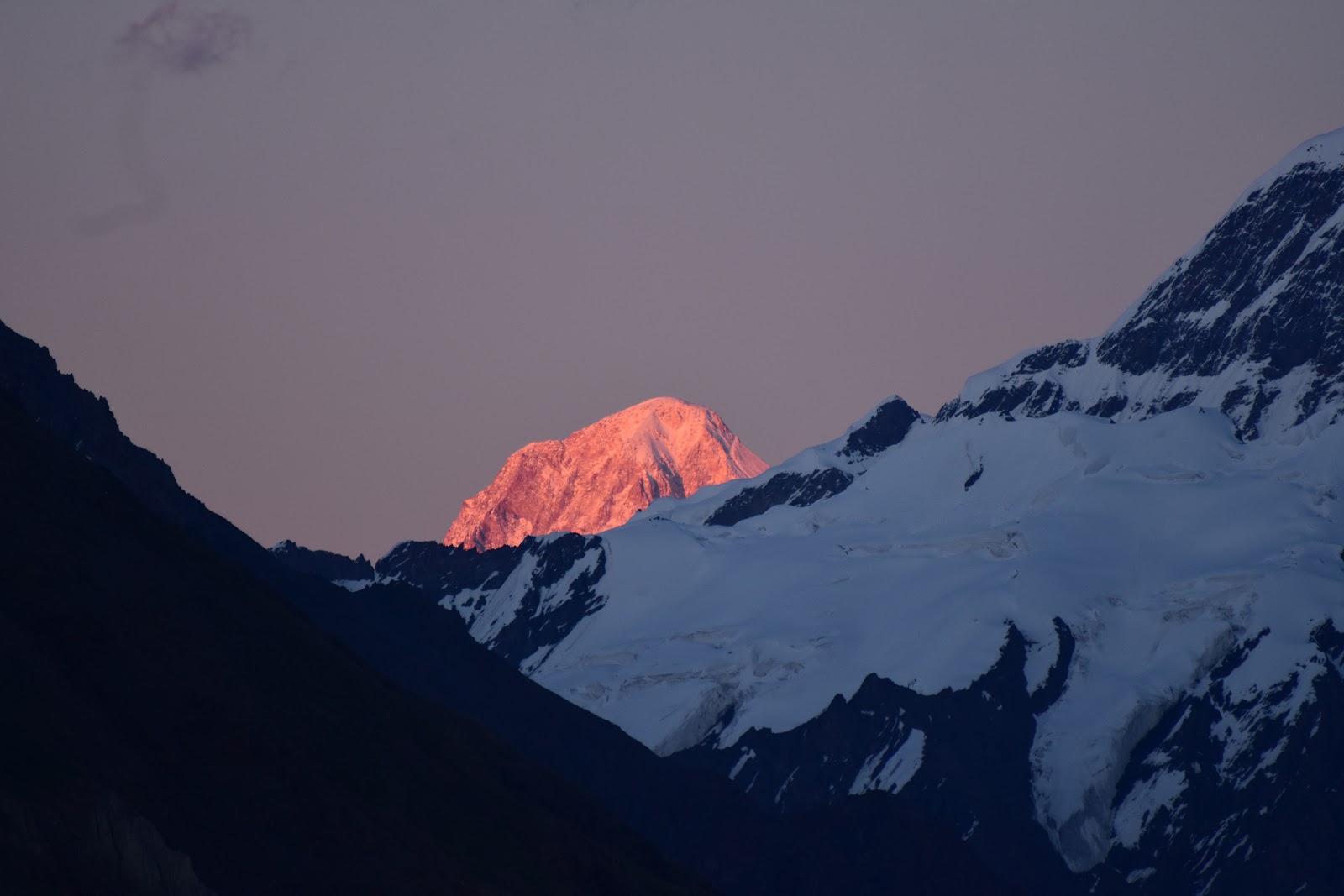
Day Three: July 12, Iva Camp to Glina Camp (3160 m)

 |
| Viktor, Terri and Lena |
 We awoke the next morning to glorious, sunny weather. We breakfasted heartily on eggs, sausage, cheese and bread (did I mention that the food was always plentiful and tasty?) and set off at 8:20. We were fortunate that the previous day Lena, the woman working at the next camp, Glina, had been visiting Iva Camp and was returning. We walked with her all day, and Viktor accompanied us for the first two hours to make sure that we (and Lena) were sure of the path. We were glad as it was by no means obvious how to find the way through a maze of river crossings, glacial moraines, lakes and ice cliffs. When Viktor turned back, we were sorry to see him go as Lena was new to the Inylchek that season and far less experienced in finding her way.
  We managed to make our way along a narrow terrace beside the glacier itself to the junction with a large tributary glacier. At this point the path had melted away, leaving a hair-raising descent along steep, slippery gravel. We searched for the best place to try to descend, and Lena went first, skidding out of control down the slope for twenty metres before managing to control her speed; a series of moderate-sized rocks followed her down and pummelled her as she sat, slightly dazed, at the bottom. Terri and I opted for a different spot, and we pulled out the 25-metre rope that we had bought in Karakol a few days earlier. I belayed Terri as she picked her way gingerly down, and then lowered our packs before throwing the rope down. I had no rope, and had to slide as carefully as possible, using my hands, feet, butt and legs to maximize friction. I made it to the bottom unscathed, but it was a signal of future dodgy sections to come.
 We climbed steeply up the opposite bank of the tributary and, after lots of ups and downs, finally popped out at Glina Camp. It had been a surprisingly hard day, covering only 12 kilometres in nearly six hours. Lena set to work immediately in the kitchen on our dinner, while we sat and sketched. I pulled out my juggling balls for a session, and Vikram, Lena's camp-managing partner, asked to try. I gave him a brief lesson and was impressed with his natural hand-eye co-ordination.
Dinner was warm and convivial, and we went to bed in a good mood despite our route-finding and cliff-descending frustrations.

Day Four: July 13, Glina Camp to Merzbacher Glade (3420 m)
 We awoke to clear skies, but clouds further up the valley portended a change in weather. In comparison with the previous day, our route was easy to find. We walked all day along the narrow elevated corridor between the edge of the glacier and the steep cliffs towering above us to the south. Our eyes were adjusting to pick out the unobtrusive stone cairns that marked the path, and the day's route was far flatter and easier to follow. We passed through small meadows alive with birds (Guldenstaedt's redstarts, water pipits, snowfinches and nightingales were prominent), wildflowers and thorny shrubs that tugged at our clothing and pierced our skin if we weren't careful.
It took us four hours and forty minutes to cover the day's stage, and it was a joy to be able to walk without having to devote much mental energy to navigation. Merzbacher Glade camp hove into view shortly after one o'clock, a far more substantial camp than Iva or Glina had been. Glaciologists from all over the world descend on the camp every summer to study Merzbacher Lake, a glacier-top lake that forms every summer before suddenly draining when its ice dam melts away. We had looked forward to seeing the lake, but on the night of July 10-11, while we were asleep in Karkara, it had emptied, so there was nothing to see except a large collection of white icebergs that had calved into the lake and which were now stranded on top of the glacier's rocky top moraine.

 We sat and rehydrated with cups of tea in the dining tent, chatting with Misha and Larisa, the couple running the camp, absorbing the views across the South Inylchek to the North Inylchek Glacier and its now-empty lake. The wind soon picked up and drizzle began to fall, driving us into our tent for an afternoon nap after having the luxury of washing with hot water in the portable sauna (showering/washing facilities were available in every camp, making for a very civilized experience). Birdwatching in camp was good, as it was a rare oasis of green in an austere, sere landscape. We were in bed early, pleased with the day's progress.
Day Five: July 14. at Merzbacher
 |
| A dining tent with a view! |
We had two nights scheduled at Merzbacher Glade, leaving us a day to cross the Inylchek to see Merzbacher Lake up close. As it was empty and the glacial crossing was said to be tricky and arduous, Terri and I chose instead to have a lazy day off in camp. The weather was cold, drizzly and uninspiring (cancelling the day's scheduled helicopter flight to pick up a number of glaciologists), so we spent the day sketching, reading, snoozing and chatting with glaciologists and, later, a trekking group of eleven elderly Japanese trekkers and their energetic guide Hitomi. They arrived with two Kyrgyz guides and no fewer than nine porters to carry their personal luggage. We ended up being invited to a feast of Japanese snacks with them before dinner, and sat around afterwards having beers with Hitomi and one of the trekkers, along with a few of the guides and porters. It was a rare evening of socializing with other trekkers on our otherwise rather solitary journey.
Day Six: July 15, Merzbacher Glade to Komsomolskiy Camp (3720 m)

We were awoken the next morning (as we had been the day before) by Naoki, a young Japanese glaciologist, flying his drone over the glacier at first light at 5:30 am to take photos of a series of smaller glacier-top lakes. No sooner had he finished than we heard the distinctive whump of helicopter rotors approaching. There was a flurry of activity as sleepy glaciologists raced out of their cabins lugging backpacks and boxes of scientific gear, and then they were gone, the helicopter arcing out over the rocky surface of the Inylchek as they departed for the lowlands.
 Our day went very poorly. We had the longest glacial stage of the trek in front of us (12.5 km), and Terri had been fretting about possible route-finding issues for the past two days; as it turned out, she was right to worry. I had scouted ahead the afternoon before, heading an hour out of camp and learning the route, taking time to build more prominent cairns in areas lacking in route marking. That morning we steamed ahead effortlessly through this section of the trail, but as soon as we were on new terrain, we began to struggle. We knew that we had to get to a large tributary glacier, and then finally abandon the terrace beside the glacier and descend onto the moraine of the main glacier. It was a long, frustrating and convoluted path that we followed, eventually making our way out onto a long, narrow black moraine that would lead us to the Komsomolskiy Camp. The Inylchek, like many major glaciers, is striped lengthwise by different coloured moraines carrying the different rocks eroded by its various tributaries. This black moraine originated from the Komsomolskiy Glacier, one of the biggest tributaries joining from the massive peaks south of the Inylchek. It was easy enough to follow in theory, but in practice the route was heinously difficult. The cairns left by previous trekkers were tiny, almost pathologically minimalist, and easily missed in a landscape consisting exclusively of rock fragments. We eventually tuned into their subtle clues, but the path was relentlessly up and down, leading over large ice peaks thinly covered in gravel and rocks. The gravel was often so soft that we sank into it, while uphills were made harder by the moraine material sliding under our feet almost as quickly as we climbed up it. Terri was unspeakably frustrated, especially when we had to stop and cast around for our next cairn, or when we had to search for a path around a steep ice cliff blocking our path.
 When we stopped for a late lunch, I was amazed to find that it was already 3:30, with more than half the day's stage still in front of us. I was worried that we would be arriving well after dark, especially when the sky darkened and a succession of rain, hail and snow fell on us, dampening our clothes and our spirits. Just as we were starting to despair of getting to Komsomolskiy before dark, we spotted the characteristic yellow tents in the distance and a man standing outside them. We shouted and waved, and then kept plodding along, heads bowed down to search for the next trail marker. Suddenly there was a whistle and we spotted a man hustling across the glacier towards us. It was Ivan, from Komsomolskiy Camp, and he was beside us a few minutes later. He knew from the camp radio that we were on our way, and had been concerned at our non-appearance. He took Terri's pack and led us at a brisk pace across the moraine and up onto crunchy white ice to the camp; it took us twenty minutes to cover what Terri and I on our own would have taken an hour and a half to navigate. I was really quite chilled (I still had my shorts on), while Terri was tired and frustrated. It was 6:15 pm, so we had been underway for nine and a half hours, a pathetically slow pace.
 |
| Terri and our rescuer Ivan |
Ivan's partner Olya soon had the best meal of the trip in front of us, a delicious bean and lamb soup followed by the most delicious pasta. We drank endless quantities of fluids to rehydrate, then retired to our tent early to recover in the arms of Morpheus, grateful to have made it and happy for the food and hospitality of our hosts.
 |
| Relieved to have made it! |
Day Seven: July 16, Komsomolskiy Camp to Dikiy Camp (3970 m)
 |
| Komsomolskiy Peak |
 |
| Gorkiy Peak |
 We slept the sleep of the dead that night and woke up feeling remarkably refreshed, despite now being at 3720 metres above sea level. The weather had cleared and brilliant sunshine bathed the peaks. After breakfast Terri, determined not to have a repeat of the previous day, asked Ivan to show us the route out of camp. He agreed, and we strode out of camp briskly at 9:00, Terri and I hustling to keep up with his confident pace. He took us across two moraines to the black Dikiy Glacier moraine and then turned around, eager to get back and prepare for the Japanese invasion later that day.
  We spent the day walking along the moraine, a far smoother surface than that of the previous day. We made steady, if unimpressive, progress, spending the day admiring the incredible mountain architecture around us, by far the most impressive of the trip so far. To the north, we looked up at the bulk of Komsomolskiy Peak, while to the south a progression of peaks, each taller than the next, rolled onwards: Petrovskiy, Gorkiy, Chapaev and, finally, Khan Tengri, which had been hidden from view for several days by the intervening summits.
 |
| These are the sorts of rock cairns that we had to search for to find the path! |
 |
| Terri started to make larger and more colourful cairns to help out subsequent groups |
 Almost as impressive were the views to the south up a series of large tributaries: the Komsomolskiy, the wonderfully named Glacier of the Proletarian Tourist, and, finally, the Dikiy. We slowed down as the Dikiy Glacier came into view as we tried to figure out how to reach the camp, located well above us on the tributary. After some trial and error, we got close enough to summon the assistance of Vassili, the male half of the camp team, and he trotted out wearing Crocs to show us the way into camp.
 |
| Pik Pobedy in the pink light of evening |
It was a magical location, looking up at Khan Tengri in one direction, and the broad bulk of Pik Pobedy in the other. We arrived at 3:30, leaving plenty of time to bathe, drink copious cups of tea, sketch the elegant lines of Khan Tengri and Pik Gorkiy and spend some time reading and juggling. That evening, after dinner, Terri and I sat out and watched the light on the western faces of Khan Tengri and Pobeda gradually acquire a rosy hue. It was a breathtaking scene of natural beauty, and as we sipped our evening tot of Armenian brandy, we felt enormously at peace with the natural world. Suddenly, all the physical effort and frustration seemed worth it to see these amazing mountains.
 |
| Khan Tengri's beautiful summit |
 |
| Nighttime in Dikiy Camp |
Day Eight: July 17, Dikiy Camp to South Inylchek Base Camp (4100 m)
 |
| Terri contemplating Gorkiy, Chapaev and Khan Tengri from Dikiy Camp |

Our last day was said to be easy, the shortest stage of the trip. We set off at 8:40 with fond hopes of being at base camp by 1:00. It was not to be. Instead, we had the longest, toughest and most alarming day of the entire trip.
 |
| Beautiful fluting near Pik Pobedy |
It all sounded so simple. We needed to cross over yesterday's black moraine, a white ice sheet, an orange moraine, another white strip and finally get to a grey moraine, which we would follow all the way to base camp, only 6.5 kilometres away. Easy, right?
Not so. It took us two hours to get across the first white ice sheet. The surface was melting rapidly, and the meltwater carved deep, steep valleys into the ice that were impossible to cross, so we headed upstream, trying to find less steep sections to cross. It was mentally and physically draining, and we were intensely frustrated at not being able to find where groups usually crossed.
 |
| Terri amidst the maze of the first white ice strip |
When we got onto the orange moraine, we made our way quickly across to the next white ice sheet, which had looked flatter from a distance. We could not have been more mistaken. While the ice was zebra-striped with layers of black ice, making for a beautiful appearance, it was far steeper, with higher ice cliffs, than the first white section. We searched for hours for a safe way to cross. At one point we found trail markers and rejoiced, but then we could not figure out how the groups had crossed a deep river valley in the ice. Eventually, after much backtracking, scouting and arguing, we figured out that we had to descend to the river and wade across it at a narrow spot. The only problem was that it was now 1:30 in the afternoon and the river was raging. It looked to be too deep to wade, so I stripped off my clothes, tied a rope around myself and launched myself across the river, hoping to swim across before the current swept me downstream. Imagine my annoyance when I bounced off the bottom; it was only mid-thigh in depth! I waded out of the river on the other side and we laboriously slid our packs and other luggage across the river on our rope before Terri waded across. I was very cold, but at least we were now across the river and onto the grey moraine.
 |
| Zebra-striped maze |
This proved not to be the case. The flagged route was the trickiest yet, leading precipitously up ice pinnacles and across narrow ridges, over deep, wide crevasses and around deep glacial lakes. Terri was seriously alarmed at several of the ascents. Finally the base camp hove into view and we made our weary way to the final river crossing. The camp staff had installed a ladder to descend from a metre high ice ledge, and Terri began to giggle hysterically: after all the objective danger, there was finally one safety feature for the least perilous part of the entire day. We trudged wearily up to the chaos and clutter of South Inylchek Base Camp, far larger and more untidy than any of the trekking camps. It was 6:30 and we had taken nine and a half interminable hours to cover 6.5 kilometres; we might almost have been able to crawl faster than we had walked.
 |
| Base Camp at last! |
We wanted to celebrate with a beer (sold at all the camps), but there was no beer to be had, to our intense annoyance. We settled into the dining tent, devoured a large fraction of our body weight in chocolated, and then scarfed down supper, a far less satisfying meal than any we had had along the route so far. I chatted briefly with a couple of groups of mountaineers, then retired to our tent for a well-earned night's sleep, unrewarded by any view whatsover of the great peaks.
Day Nine: July 18, South Inylchek Base Camp to Karkara Base Camp
 | ||||
Merzbacher Glade from the air
|


We awoke to low clouds and dark skies down the glacier. We were supposed to have another rest day in base camp to take pictures, but there were no pictures to be taken, and a real risk of being snowed in if the choppers couldn't fly the next day. At breakfast the camp manager, Dima, came by and said that a helicopter was inbound and had room for us if we wanted to go back to Karkara a day early. We jumped at the chance, packed up rapidly and at 10:00 climbed aboard the familiar white helicopter. We made a few stops (at Dikiy, Komsomolskiy and Iva) to deliver food supplies, and still managed to cover the entire length of the glacier, which had taken us six full days (some of them too full!) to walk, in half an hour. Then we lifted up over the pass and by 11:00 we were disembarking in Karkara. It was an unspeakable relief to be back on solid, grass-covered ground, full of flowers and horses and birdsong. We spent the afternoon relaxing and strolling around, and the evening filling out our "footprint" to hang on the wall in the bar in Karkara.
 |
| A good summary of our trip! |
 |
| On the ride out |
Day Ten: July 19, Karkara to Karakol
Two hours of reckless driving, partly along a tiny mountain backroad track, brought us back to Karako and the comfortable embrace of the Hotel Madanur, where we took much-needed showers, brushed the knots out of our hair and relaxed in the indescribable comfort of real beds. Our adventure was over, and we were both elated and relieved. My Salomon hiking boots, less than a year old, were a mess, with one sole disintegrating entirely, to my intense frustration! Terri's boots had held up, but her tailbone is badly bruised from a slip on the white ice on the last day; hope it improves before our horse trip in two days' time!!
In hindsight, not hiring a guide was a false economy. On the days when we had help finding the route, we made reasonable progress. On days when we had no assistance and the route was tricky, we wallowed in ignorance and made no progress for long, soul-destroying hours. A route along a big glacier is tough to navigate without local knowledge, as it's constantly changing as the glacier moves and melts.
Overall it was an amazing adventure, with incomparable mountain views, but it certainly wasn't an easy walk. I would recommend doing it, but come prepared for tough walking, and hire a guide!
 |
| The shredded soles of my boots |