Lipah, Bali
 |
Cormorant at Whites Bay
|
It's been seven months since Terri and I made it to the South Island and began what was for me the most beautiful and most consistently awe-inspiring part of our entire seven months in New Zealand: the Kepler, Milford and Routeburn Tracks, the three Great Walks which are located close to the small town of Te Anau, in the deep south of the South Island. Thirty years previously, my friend Hans and I were backpacking around New Zealand and found ourselves in nearby Queenstown, where we seriously considered hiking the Routeburn; we changed our mind when we met other trekkers who had just come off those tracks and reported unseasonable blizzards and deep snowdrifts. Since then, these hikes have been on my mental radar. Terri, as a New Zealander keen on trekking, had been aware of these treks for her entire adult life, but was put off walking along them by the difficulty of getting reservations for them. The ten Great Walks of New Zealand have become insanely popular among tourists from all over the world, and these three have the greatest demand. The Milford Track, in particular, has a reputation for selling out within minutes of reservations being opened, months before the trekking season even begins. Covid-19, by bringing international arrivals into New Zealand to a crashing halt, provided us with an unmissable opportunity to be able to get reservations for these tracks, as we were competing for spaces with a much smaller pool of applicants than usual. In late November, while we were in the south of the North Island, we went online and were able to book the Milford Track, followed in short order by the Kepler and the Routeburn. All three are pretty expensive (particularly the Milford), but we figured that it was a once-in-a-lifetime opportunity not to be missed. Reservations in hand, we structured our time in the South Island around these trips and started to get excited.
 |
| Whites Bay |
 |
Whites Bay
|
We took a middle-of-the-night ferry to the South Island on the night of November 29-30 and headed straight to a Department of Conservation (DOC) campsite at nearby Whites Bay where we caught up on missed sleep, did a short hike and collected an abundance of mussels from the nearby rocks for a seafood feast.
We spent four days driving south towards Te Anau, via Kaikoura and its coastal loveliness (sadly we didn't spot any of the incredibly rare Hutton's shearwaters that feed just offshore), Wooded Gully (a pretty DOC campsite not far from Christchurch), lovely Lake Tekapo, Twizel (where we camped at pretty Lake Wardell), Queenstown (where we stayed with my friend Natalya's parents, international teachers and world travellers Brian and Marion), Glenorchy and finally Te Anau. It was a whistle-stop tour, although we were confident that we would return to spend more time in some of these places after our Te Anau treks.
 |
Kaikoura
|
 |
Terri in a field of lupins, Lake Tekapo
 | New Zealand scaup family, Lake Wardell
 | New Zealand scaup, Lake Wardell
|
|
|
 |
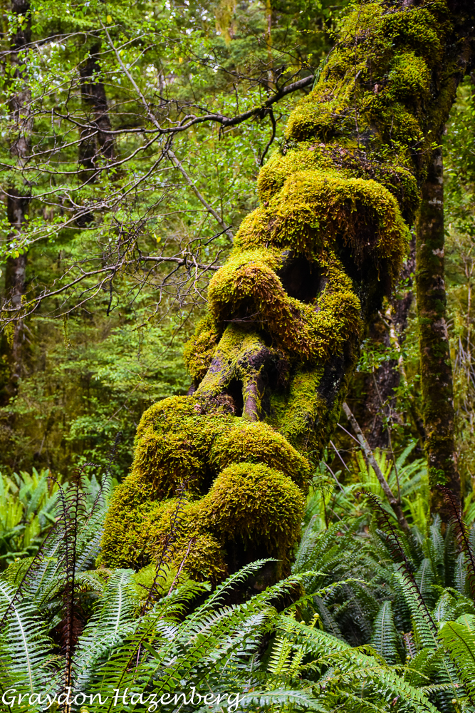
Mossy native bush along the Kepler Track
|
We had a couple of nights in Te Anau before we set off on the Kepler Track; we spent them camped behind the Parklands Motel which would become our home base between treks. On December 5th it rained incessantly all afternoon. We had to go out to the DOC office to sign in for our trek, to the supermarket to stock up on trekking food and then to a fish and chips joint for dinner. By the time we got back to the van, Terri was almost hypothermic; the temperature was down around 6 degrees and very un-summerlike. Luckily the fish and chips and wrapping herself in her sleeping bag got her functional again by the time bedtime rolled around.
December 6th found us sleeping in, feeling a bit groggy and slow to get moving. By 10 o'clock we were ready, and we parked our van at the motel, shouldered our packs and started walking. The nice thing about the Kepler Track (unlike the Routeburn and the Milford) is that it's accessible on foot right out of the town of Te Anau. We walked along the shore of Lake Te Anau for an hour to the official entrance to the track at the exit gates controlling the level of the lake, and then another hour further along the lakeshore to Brod Bay. The walk was through a lush, moss-clad beech forest, full of birdsong (although bereft of any visible birds).
 |
Limestone cliffs on the climb up to Luxmore Hut
|
From Brod Bay the track began to ascend at a gentle, steady angle. Being a Great Walk, the track was luxuriously broad, smooth and well-maintained. As we gained elevation from the lake (210 metres above sea level), we passed first through more mossy beech forest, then past a set of limestone cliffs and then out onto tussocky open moorland. The sky was overcast, lending an even more Scottish feel to the landscape, but luckily it didn't rain. The track wove gently up the slope, and we arrived at Luxmore Hut (1070 m) by 2:45 pm, meaning we had been walking for about 4:45. It seemed like a much easier first day than we had anticipated, but we were still glad to doff our backpacks, claim a bed and settle into the comfortable confines of the hut.
We broke out our trusty MSR camping stove and lightweight aluminum frying pan and produced some grilled cheese sandwiches for a late lunch. There are some caves a few minutes' walk from the hut, and we set off for a post-prandial constitutional to see them. The caves were small and steeply sloping, but attractive, and we pottered around inside contentedly for a few minutes. Sadly we didn't spot either of New Zealand's two surviving native mammal species (the short-tailed and long-tailed bats), although there had been reports of hikers seeing them near the caves. We ambled back downhill to the hut, did some stretching (we had barely trekked with heavy packs on for over a year) and watched the afternoon light colouring the Murchison Mountains, across an arm of Lake Te Anau. The Murchisons are the last stronghold of the takahe, a highly endangered native bird thought to be extinct until it was rediscovered in the remote bush of these remote mountains in the 1940s by Geoffrey Orbell, a doctor and keen outdoorsman obsessed with the idea that the takahe had survived in the middle of nowhere. We had seen a couple of the 200 or so surviving takahe in a secure enclosure at the Te Anau Wildlife Sanctuary a few days before, but we were keen to see them in the wild. (Sadly, this wouldn't happen; they're very reclusive, secretive birds, rarely seen in the wild.)
 |
Takahe at the Te Anau Wildlife Sanctuary
|
There was a jolly atmosphere in the hut that evening as a few dozen keen trampers (mostly New Zealanders, with a smattering of other nationalities, mostly resident in the country) whipped up food to replenish the calories burned in a day of walking. We struck up a number of conversations with our fellow trampers, sharing stories of the day and tips about other treks around New Zealand. As is the custom along the Great Walks, the hutkeeper came out to give a talk about the history, botany and birdlife of the area after dinner, as well as checking our hut bookings. This particular warden had done his Master's degree testing kea parrots for intelligence and problem-solving ability, and had a number of amusing stories to relate about the pitfalls of trying to outsmart the world's smartest bird. We were all in bed and asleep relatively early.
 |
Wildflowers near Luxmore Hut
|
 |
View across the tussocks to Lake Te Anau
 | Lovely wildflower up on the moorland near Luxmore Hut
|
|
 |
| Yours truly near Luxmore Hut |
 |
Mountain daisy and cool insects
|
 |
Early morning views from the Luxmore Hut
|
I awoke with the dawn the next morning and slipped out of the hut to see what sunrise would look like. The previous day's clouds had dissipated and the view from Luxmore Hut was fabulous, with range after range of distant snow-capped peaks rising out of a sea of low-level cloud. It was cold (only a few degrees above freezing), but the clarity and colour more than made up for the chill. As I was returning to the hut, I saw a trail runner appear, trotting up the trail we had followed the day before. The Kepler Track is a classic trail run in New Zealand, and this guy hoped to complete the 60-km route in about 8 hours, rather than the 3 days we hikers were planning on.
 |
Early-morning panorama of the Murchison Range
 | Terri on day two of the Kepler Track
|
|
 |
Lovely ridge walk leaving the summit of Mt. Luxmore
|
After a hearty feed of oatmeal to see us through a long day of hiking, we packed up and hit the trail by 7:30, the first party of the day (not counting the runner). It was a perfect day for walking, with every corner bringing new sweeping vistas of mountain peaks. As we ascended towards Luxmore Peak there was more and more snow on the ground, the remnants of what had fallen two days earlier (the rain we had in Te Anau fell as snow higher up). At the junction point where the side trip to the summit of Luxmore branches off the main Kepler Track, there were a couple of keas, keen to harass us and perhaps steal some food from our packs. We kept a wary eye on the pair, took some photos and then strolled up to the peak. When we returned, we found the next set of trekkers trying to protect their packs from the inquisitive, mischeavous parrots. Keas are relatively rare nowadays, with somewhere between 3000 and 5000 found throughout the South Island. Sadly some 160,000 keas were shot and poisoned throughout the mid-20th century, allegedly to protect sheep; New Zealand's history of how it has dealt with its native flora and fauna is a long litany of human-made disasters.
 |
Striking scenery to walk through
|
 |
Wildflowers
|
 |
Across the valley
|
We spent the next few hours undulating along tussock-clad ridges. The views down to various arms of Lake Te Anau and across to the Murchison Range were ever-changing and never dull, and kept our minds off the amount of climbing and descending that we were doing. We passed Forest Burn and Hanging Valley shelters, both perched in dramatic spots and featuring resident delinquent keas. Eventually, just as we were starting to wonder if our maps were correct, the path finally began a long, steep descent back into the forest. It was a long trudge and our legs, unused to descending so steeply with packs on our backs, were protesting by the time the path debouched into the flat bottom of Iris Burn valley. The forest was once again enchanting, something out of a fantasy novel, with everything wreathed in dense veils of moss.
More wildflower colour
 |
| One of the arms of convoluted Lake Te Anau |
 |
Fabulous foliage
|
 |
Stunning open moorland on day two
|
 |
Pretty pleased with the weather and scenery
|
 |
Terri facing down a cheeky kea
|
We got to Iris Burn Hut by mid-afternoon, made more grilled-cheese sandwiches and then headed out for a swim to rinse off the grime of a long day of trekking. The water was cold and the air was thick with sandflies, so we didn't linger, but instead walked up to a nearby waterfall. We returned to the hut and set about preparing dinner (sweet potatoes slathered in cheese and pasta sauce). Our hut warden, a veteran Swiss-born woman, told us that we were in a hot spot for kiwis and bats, so after our hut talk, we walked out in search of both these rarely-seen animals. We could definitely hear kiwis calling, but we had no luck at all seeing them. When we returned to the hut, defeated, we learned that another group had spotted a kiwi about one minute after we'd passed them in the forest. There were no bat sightings, and we sank into bed and fell asleep immediately, much later than usual.
 |
| A kea, perhaps the most intelligent and mischievous bird on Earth |
 |
Descending into the lowlands again
|
 |
Waterfall
|
 |
Very pretty wildflower
|
Our final day of hiking was long but easy. Many hikers split the trek into 4 sections, but we decided to save money on hut fees by having a long final day (22 km), and shaving 9 kilometres off the walk by hopping onto a shuttle bus from Rainbow Reach bridge back to Te Anau. The walk was downhill all the way, so that our legs, which were pretty tired from the long, steep descent to the hut, wouldn't suffer too much. We were underway by 7:40, walking through an amazing enchanted forest, full of birdlife, including numerous bellbirds and some personable and confiding South Island robins. We took a brief lunch break at Moturau Hut, on the shore of Lake Manapouri, but we were besieged by persistent sandflies, so we didn't linger. The last stretch of the track leading into Rainbow Reach along the pretty Waiau River was supposed to be a good place to spot New Zealand falcons, a bird that we had yet to enounter, but we had as little luck with them as with kiwis. By 1:40, leg-weary but exultant, we emerged at Rainbow Reach having completed 51 km over three days. We relaxed on the grass, chatting with other trekkers as they filtered in. At 3:00 the shuttle bus appeared and we hopped aboard for the final stretch into Te Anau. We could probably have walked, but we were pretty tired and the last stretch didn't look unmissable. By 4:00 we were back at the Parklands, setting up our camp again and getting a bucket shower. I wandered out to get Indian takeout which we devoured before turning in early for a well-earned rest.
 |
Waterfall near Iris Burn Hut
|
 |
| South Island robin |
 |
| More wildflower loveliness |
 |
| Fungal funkiness |
 |
| On the long trudge out of the Kepler |
 |
| Very pretty beech forest |
 |
| Mushroom multiplicity |
 |
Lake Manapouri
|
 |
The Waiau River
|
We had two days off before our booking on the Milford Track. The first day was spent in utter sloth at the Parklands under grey skies. On the second day we packed, bought groceries and then went for a bicycle ride along the Waiau River, getting a view of the section of the Kepler Track which we had skipped.
 |
| A life-long dream come true! |
December 11th dawned grey and drizzly. Our (extremely expensive) bus and boat trip to the start of the Milford Track didn't leave until early afternoon, so we had a leisurely getaway. We packed up our backpacks and our van, did a workout on our gymnastic rings (slung over a children's swing set in the motel grounds), then wandered over to the DOC office to check in. We were glad to discover that since I had gotten a New Zealand driver's license back in October, I was now regarded as enough of a New Zealand resident to be given resident's rates for park fees and hut fees, saving me the better part of NZ$ 100, while we both qualified for further discounts for being members of the New Zealand Motorhome and Caravan Association (NZMCA). Soon enough a bus appeared to whisk us, along with a score of other hikers, north up the shore of Lake Te Anau to the boat dock at Te Anau Downs. We got aboard a reassuringly large and solid boat for the ride across and up the lake to Glade Wharf.
 |
Tomtit near the start of the Milford Track
|
Terri was keen to leap ashore and race ahead of the wave of trekkers exiting the boat, but first we had to stop for a photo celebrating the fact that after a lifetime of dreaming of it, Terri was finally about to start the iconic Milford Track. We walked for an hour along a level, easy track through (once again) dense, atmospheric forest to reach Clinton Hut. There was still low cloud cover, so we didn't see much of the peaks surrounding us, although we had an impression of bulk and steepness. The Clinton River had vivid postcard colours in its waters and pebbled beaches, while the forest was alive with robins, bellbirds, tomtits and (to judge by the birdsong we heard) possibly the very hard-to-spot mohua, or yellowhead. We kept up our tradition by concocting grilled cheese sandwiches for a mid-afternoon snack before wandering out to look at the wetlands around the hut, hoping forlornly that we might see the always-elusive kotata (fernbird). We returned to cook up a superb dinner of steak, sweet potatoes and broccoli, washed down with a bottle of wine.
 |
On the way to Mintaro Hut
|
December 12th was a red-letter day, the highlight of the Milford Track. We were up betimes (Terri had been kept up for much of the night by a persistent snorer), made a quick breakfast of porridge and were the second walkers onto the track at 6:45. The weather was slightly overcast, but it cleared as we walked upstream along the West Branch of the Clinton River. The path led through dense forest, with long stretches along the crystalline waters of the river. There was a great deal of birdsong, along with sightings of tomtits, wekas with babies, bellbirds and even a kaka (a cousin of the kea) singing lustily in the treetops. The river was patrolled by scaups and paradise shelducks, while Terri was lucky to spot a South Island saddleback as it flew across the track. One species we didn't see was the whio (blue duck), a rare endemic said to inhabit the waters of the Clinton. After a short snack stop at Prairie Shelter (it was shortened by persistently annoying sandflies), we climbed on past avalanche debris, gaining altitude as we approached Mintaro Hut under cloudless blue skies, arriving at the stroke of noon.
 |
Some lovely scenery along the Clinton River
|
 |
Kaka calling loudly near Mintaro Hut
 | More pretty wildflowers
|
|
 |
A troublesome kea about to be caught and banded
|
Fortified by another grilled cheese sandwich, we claimed our beds, left our heavy packs and set off uphill towards MacKinnon Pass. We would follow this route the next morning, but the weather forecast for the morrow was dire, so we felt impelled to see the scenic highlight of the entire track while the weather was good. Unencumbered, we made good time uphill along switchbacks carved into the steep hillside. We were on top of the pass by 2:00, absorbing epic views of precipitous glacially carved peaks and a plethora of waterfalls cascading down cliffs. In the foreground a wealth of alpine wildflowers provided bright splashes of colour, while in the distance we tried to descry the following day's descent. Near the top a team of volunteers was trying to capture and band keas. We watched as a curious kea was lured forward by a colourful rag doll to step into a lasso loop lying on the ground; a quick tug and the bird was captured. Despite its reputation for fierceness, the kea was surprisingly docile as the volunteers weighed and banded the bird. We left the scientists to their work and continued onwards to the MacKinnon Shelter for a different angle on the mountains, looking back towards the Clinton Valley we had walked along that morning across a series of tiny picturesque tarns. After snapping too many photos, we turned and trotted back downhill towards the hut, trying to encourage stragglers who were labouring uphill. We leapt into a swimming hole to freshen up after a long, sweaty day, then cooked up a feast of pasta carbonara and bacon). We socialized over mugs of whisky, listened to a highly entertaining hut talk, and then retired tired but content to our sleeping bags.
 |
Don't step in the lasso loop!
|
 |
MacKinnon Pass
|
 |
Near the top of McKinnon Pass
|
 |
A very happy Terri atop McKinnon Pass
|
 |
More stupendous wildflowers
|
 |
McKinnon Pass redux, this time in the rain and clouds
|
We slept in to the late hour of 6:40 (the encircling ridges kept out the morning light, and it was an overcast day), gobbled some oatmeal and were walking by 7:30. The leaden skies soon turned to rain, and it kept up all day. We trudged uphill wearing our rain jacket and rain pants, our packs sheathed in rain covers. We went over the top of MacKinnon Pass unable to see 10 metres in front of us, glad that we'd come up the previous afternoon. We recharged with snacks at the Pass Shelter, then descended steeply into the Arthur River Valley. There were sections of track which had been raked by avalanche debris during the previous winter and spring, then a dramatic descent beside an impressive river which was an endless series of torrents and pools. Two and a quarter hours saw us emerge at Quintin Shelter, where we left our packs and enjoyed a cup of tea before heading uphill towards Sutherland Falls, the highest waterfall in Australasia.
 |
Ephemeral waterfalls
|
 |
Looking down on the upper Arthur River
|
 |
| Whio (blue duck) showing off |
We didn't see much of the falls as they were so high that their upper half was lost in the low clouds, but the sidetrip was worth it for an encounter with a whio. As we crossed a suspension bridge near Quintin Shelter, we spotted a male whio standing on a rock preening himself. Unlike most of his species, this duck wasn't at all afraid of humans, and stood there serenely as I snapped photos furiously. We didn't walk all the way to the base of the falls, turning back at another bridge that offered us as much view as we were going to get. It was pouring harder than ever as we shouldered our packs and trudged downstream to Dumpling Hut, arriving by 2:00 pm. We got a fire going in the common room and started to dry some of our sodden clothing and gear while Terri whipped up some pancakes and an instant cheesecake to replace the calories we had burned. We lounged about, reading and writing in diaries until it was time to cook up curried lentils for supper. We were in bed shortly after the obligatory hut talk and a snifter of whisky.
 |
Beech forest in the Arthur Valley
 | Lunch of champions
|
|
 |
Lower Arthur River
|
Once again sleep was interrupted by snoring; the offender was sleeping directly above Terri, who kept poking his bed with her hiking pole to wake him up when his snoring got too loud before finally decamping to the common room to try to catch some uninterrupted shuteye. We were off by 6:40, barrelling down the path, worried about making our boat connection at 12:30. As it turned out, we were in plenty of time, and we had splendid views all morning of waterfalls, pools in the river, and abundant birdlife. We swam at Giants Gate and then made it to Sandfly Point by 11:15 (it failed to live up to its monicker, to our great delight). We had completed 54 km over three days (and an hour on the first day), and we felt pretty good about it. We lounged on the dock, resting our feet and watching scaups and passing fishermen in sea kayaks, until a speedboat appeared to whisk us to the "town" of Milford Sound.
We had gotten a cruise of Milford Sound included in the price of our package of transfers, and it was a glorious day for it. There were hardly any tourists around other than us, and the big cruise boat we were on only had a dozen or so other punters aboard. We were hoping to spot Fiordland crested penguins, but we struck out (they had been spotted that morning, but were out at sea fishing when we sailed past). There were, however, plentiful bottlenosed dolphins and a handful of seals, along with no end of spectacular waterfalls, hanging valleys and snow-capped peaks. We returned to the ferry terminal, went for a brief stroll around to get some more views of the sound, then caught our bus and snoozed our way back to Te Anau and the familiar confines of the Parkland, where we broke with routine by opting for Thai takeaway (since the Indian restaurant was closed due to a lack of customers).
 |
So close to the goal!
|
 |
Old man's beard
|
 |
Almost there!
|
 |
Another perfect waterfall
|
 |
Your humble correspondent, Milford Sound
|
 |
Yet another spectacular Milford Sound waterfall
|
 |
Pod of dolphins, Milford Sound
|
 |
| Bottlenose dolphins, Milford Sound |
 |
| Feeling mighty pleased with ourselves |
 |
| One of the numerous waterfalls lining Milford Sound |
 |
Milford Sound
|
We had a very, very lazy day off the next day in Te Anau. We were weary after back-to-back treks, and were not terribly productive with our time. We did manage to get out to restock on provisions, but mostly we lounged about on the back lawn of the Parklands Motel, sleepy. As we headed to bed, my right eyelid suddenly swelled to alarming proportions.
 |
Earland Falls
|
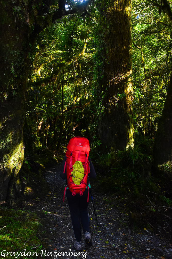
The next morning I ran around the corner to a doctor's office to see if my eye was a serious problem. The doctor confessed himself puzzled as to the cause of the infection, but prescribed some antibiotics, and for good measure diagnosed a strange lump on my forehad as a harmless but unsightly seborrheic keratoma. We rolled out of town around 11:30, headed towards the Divide, most of the way back to Milford Sound. This is one end of the Routeburn Track, and we had decided to avoid expensive transfers by doing the Routeburn as an out-and-back hike, skipping the far end and staying two nights at the MacKenzie Lake hut. This would save some 380 kilometres of driving around the mountains from the far end of the track back to the Divide. We parked our van in the carpark, donned our backpacks and set off uphill around 1:15 from a starting elevation of 530 metres above sea level. It was a steady, moderate climb uphill to Key Summit (a possible sidetrip that we took a pass on), followed by a downhill to the Lake Howden junction at an elevation of 683 m, where the Caples and Greenstone Tracks branch off from the Routeburn. From there we had a very gentle climb past pretty Earland Falls, through some scenic forest (noticeably less mossy and wet than the Milford forests) up to an elevation of 1020 m before a short, steep drop down to Lake MacKenzie (891 m) and the welcome sight of our hut by 4:50 pm. We had set out under cloudy skies and passed through some patches of drizzle, but it had stopped again by the time we got to the hut.
 |
Enchanted forest above Lake MacKenzie Hut
|
 |
Lake MacKenzie
|
We celebrated with our customary grilled cheese sandwiches (fortified with chunks of ham) before heading out for a swim. The water was less bracing than we had anticipated, and it was actually pleasant to swim around for a few minutes before clambering out to towel off. We fried up pork steaks and sweet potatoes for dinner before an entertaining but slightly long-winded hut talk by Murray, a Cockney immigrant to NZ who is a bit of a legendary figure in the world of DOC huts. He talked about the revival of bird life along the Routeburn since the start of a program of intensive trapping of invasive predators nearly 20 years ago. The Routeburn is one of the few places in the South Island where the mohua (yellowhead) is still seen in the wild, and their numbers have increased manyfold since the trapping began. It was pouring rain by now, and we were glad to be under a solid roof for the night.
 |
High up above Lake MacKenzie
|
 |
Heading out for a long daytrip
|
Unlike almost everyone else at the hut, the next morning Terri and I were able to leave our packs and set off with only light daypacks, as we would be staying a second night at Lake MacKenzie. We awoke to clear skies after the night's downpours, and we were the first walkers out of the hut. It was a steep climb up and around the lake to a point where we could look along the Hollyford Valley from high above. The air was preternaturally clear and we could see along the Hollyford to the waters of Lake McKerrow and even to the ocean beyond near Martins Bay. Through our binoculars we could clearly make out individual white-capped waves breaking just offshore, even though we were nearly 40 km away as the crow flies. We were thinking about hiking along the Hollyford Track next, so we spent a bit of time scouting it out from our elevated vantage point before continuing along our own track. The Darran Mountains soared above us on the opposite side of the Hollyford, looking steep and forbidding (this was where Edmund Hillary came to test his skills and his equipment in some winter climbs before setting off for Everest).
 |
Some glorious sunshine on the second morning
|
 |
Some snow and ice in the Darran Mountains
|
Our route contoured along at about 1000 metres above sea level, high above the Hollyford River beneath us. After a couple of hours of walking, we gained elevation and popped over Harris Saddle to a shelter overlooking the blue waters of Lake Harris. This is the high point of the Routeburn, but we had time and weren't carrying any weight, so we decided to continue onwards around the lake after fortifying ourselves with lunch at the shelter. The views around the lake and upwards towards various Southern Alps peaks were stunning, and the path itself was dramatic, perched high above the lake on a ledge carved out of steep rock. We eventually dropped down into a broad plateau beside the Routeburn River and meandered along until we reached a vantage point just above Routeburn Falls Hut. This was our turnaround point, so we gobbled down the rest of our trail snacks and set off back the way we had come. It had taken us 4 hours to reach this point, with plenty of stops for photography, food and sightseeing.
 |
Terri on the narrow ledge around Lake Harris
|
Our return journey took 3 hours and 20 minutes as we knew the route and spent less time sightseeing, particularly as the skies were clouding over and we were concerned that it might rain on us. We made it back dry and also quite pleased as we spotted a rock wren, a hard-to-see and rather reclusive native bird, building a nest right beside the track. He sat there posing obligingly for the camera for several minutes before resuming his construction activities. That evening we cooked up bacon and added it to a macaroni and cheese packaged dinner, giving our hungry bodies plenty of calories, fat and protein. We were excused from listening to a second successive hut talk that evening, but we had a number of interesting conversations with our fellow trekkers.
 |
Another unknown beauty
|
 |
Lake Wilson, I think
|
 |
A rock wren, an elusive native species
|
 |
Something a bit like an edelweiss
|
Our final morning of the Routeburn Track saw us cook up a hearty pancake breakfast before packing up and retracing our steps back to the Divide, past Earnshaw Falls and Lake Howden and the Key Summit junction. We were back at the car in only 3 hours and 20 minutes, chatting along the way with Jo, an interesting teacher from Christchurch and admiring the profusion of tiny riflemen flitting about in the bush. Once back at the car we headed out to scout the Hollyford road (completely rebuilt and repaired after gargantuan floods in 2020), hiking out to pretty Humboldt Falls before driving partway back to Te Anau to stay at Cascade Creek DOC campsite. In ordinary years, this campsite is packed, with some 130 numbered campsites; that night we were one of only 4 vehicles there. We spent time chatting with a friendly DOC worker who came to check our DOC camping pass; he told us that a huge storm was headed in the following day and that the hikers on the Routeburn might be evacuated. We spotted a giant eel lurking in the pristine waters of the river running through the campsite, along with a number of small freshwater crayfish. There were white-breasted terns beating their way along the river, while kakas and keas called and flitted through the forest canopy. It was an idyllic spot to relax after three consecutive treks, although it looked as though our planned several days of lounging were going to be curtailed by the weather.
 |
| More floral finery |
We awoke to grey skies and a confirmation that trekkers were being evacuated that day from the Routeburn, so we packed up and headed back to Te Anau where we splurged on an indoor room at the Parklands to avoid being cooped up in our awning tent and van for what promised to be a two-day storm. It was nice to have a bit of everyday luxury to recover after what had been an intense two weeks!
All three of these treks were fabulous, and provided some tremendous views, good exercise and a fun atmosphere with other trekkers in the huts. My favourite might well have been the Kepler since it involved the least transport and had so many dramatic views all the way around the circuit. The Milford is by far the most famous of the three and lived up to its billing as one of the most beautiful treks in the world, although it was also by far the most expensive because of the obligatory transport connections at both ends. The Routeburn had very pretty scenery and expansive views of the Darran and parts of the Southern Alps, but it's much shorter and has far more annoying transport connections unless you do what we did. Another option, done by several groups we met, is to walk the Routeburn one way, and then return to near your starting point by following the Greenstone or the Caples Track back. This makes it a 6 or 7-day expedition and you still have an annoying 25-km gap to fill in by hitchhiking, stashing a second car (or a bicycle) ahead of time or taking a local shuttle.
Overall I think all three tracks are worth walking, although I actually found the Rees-Dart Track, which we walked a few weeks later, to be an even more dramatic and fun walk. If I had to choose one track to walk, I would take the Milford if I could get a reservation, but otherwise the Kepler. We were both really glad that we were able to extract at least one positive thing from the Covid-19 pandemic and travel restrictions by doing these hikes that are often impossible to arrange at such short notice and so close to each other in time.
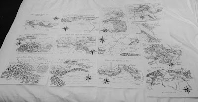
I should note in closing that we did eventually return to the Routeburn a few weeks later for a quick day hike from the eastern end up to Routeburn Falls Hut, allowing us to fill in the blank on the map that we had left by our choice of hiking route earlier. It felt good, providing closure to our Routeburn adventure!
 |
Almost back at the Divide
|