Ottawa, February 21, 2016
It’s hard to believe that almost
8 weeks have elapsed since our Christmas in Coyhaique. I have been utterly remiss in keeping my blog
up to date, but now that I’m in Ottawa, visiting my mother, I finally have a
chance to draw a deep breath, re-read my diary, consult my maps, look at my
photos and try to recreate the feeling of the second half of our Carretera
Austral adventure.
Sunday, December 27: 66.0 km
from Coyhaique to a bridge over the Rio Manihuales
 |
| More breathtaking waterfalls |
After 2 full days off in
Coyhaique with our cycling and backpacking friends Silke, Hans, Els, Vincent
and Melanie, we made a late departure from Coyhaique on December 27th,
not rolling out of town until 11 am after last-minute errands and shopping in
the big city. I was overjoyed to find
the map for the next section of our journey, map 6 in the COPEC series, for
which I had been searching ever since Punta Arenas without any luck. The ride out of town, still on perfectly
smooth asphalt, involved a steep climb that was surprisingly easy with rested
legs and bodies refilled with lots of delicious food. We looked back at the sprawl of Coyhaique, a
town whose 70,000 population makes it the biggest Chilean town between Punta
Arenas and Puerto Montt. Clouds hid the
peaks behind town, so the view wasn’t spectacular. Luckily, though, the up-close views of the
Rio Simpson, the river to which the road descended, made up for the lack of
distant glaciers. The valley was full of
big waterfalls tumbling down to the main river, some with names like the Bridal
Veil (Vela de la Novia) and the Virgin.
 |
| The view from our campsite by the bridge--not bad |
After the section of woods and
waterfalls, we passed through a long section of farms not offering many
prospects of camping. We turned upstream
on the Rio Manihuales, a tributary of the Simpson, and rode along looking for a
decent place to camp. We had been told
to look for possibilities near bridges about 60 km from Coyhaique. The first bridge after 60 km didn’t offer any
prospects at all, and we had almost given up hope when, after 66 km, the road
swept right across the main river on a big bridge and we could see a lovely
beach to our right with a few families having picnics. We picked our way down a steep driveway and
staked out a section of beach not too visible from the bridge or from the house
across the river. It was an idyllic
spot, and soon enough the other groups, mostly of Coyhaiqueans, packed up their
coolers and headed off, leaving us in sole possession of what was a very pretty
campsite on the banks of a clear, fast-flowing river. We cooked up dinner and, just as I was
starting to work on fixing Terri’s back brakes (I had never fixed hydraulic
brakes and it looked intimidating), it began to rain and we retreated to the
tent for an early night’s rest.
Monday, December 28, 46.0 km:
Rio Manihuales bridge to Laguna Pedro Aguirre Cerdo
 |
| More tumbling water |
We had an interrupted night’s
sleep as heavy rain beat down from time to time during the night, and by the
end of the night the fly had developed a definite slow leak, with rain
gradually seeping across the nylon to drip onto our faces. It had stopped raining by the time I cooked
up oatmeal and French toast for breakfast, but prospects of a timely departure
were scuttled by my continued futile struggles with Terri’s hydraulic
brakes. I was mystified by how the brake
pads could be removed and then put back; there didn’t seem to be enough room
for new, thick brake pads to fit into the available space and still have room
for the brake rotor to fit in.
Eventually at 11 am I admitted defeat and put the old worn-out pads back
in, and we pedalled off, with Terri unhappily riding a bike with essentially no
back brakes. It began raining as we
pushed our bikes up the steep hill to the road, and kept raining all the way to
Villa Manihuales, some 24 km down the road.
We were cold and miserable by the time we arrived, so we stopped into a
small café and ate tasty empanadas and cake, washed down with cold beers. There was surprisingly good wi-fi in the café
so we lingered, downloading advice on how to fix hydraulic brakes. It’s amazing how much you can find out on
YouTube these days!
 |
| The view from our abandoned campground |
It was hard to drag Terri out of
the café at 3 pm to ride further.
Luckily it had stopped raining, and we found a well-stocked supermarket
just down the road for supplies. We had
great scenery all day, with dramatic waterfalls, big cliff faces, dense forest
and the general look of parts of North Vietnam. At Villa Manihuales we seemed
to have left behind the densely settled farmland which we had been riding
through since Coyhaique. Unfortunately we also had lots of headwinds and
uphills, much to Terri’s annoyance. We
threw in the towel early, only 46 km down the road, at a place I had been told
about a few days earlier by a couple of Basque cyclists. Beside a small lake (Lago Pedro Aguirre
Cerdo, a name almost as long as the lake itself), a sign boldly proclaimed an
“Agro-Ecoturismo Camping”, but the gate was firmly locked. Peering into the compound, it was apparent
that the property was abandoned, so after some discussion we tossed our luggage
through the fence, passed our bikes over the top and wriggled inside. We found a perfect spot to camp, close to the
abandoned house, with great views over the reedbeds of the lake and sheltered
from the persistent strong winds. The
bamboo thickets and dense forest were full of birds, including a new species,
the tiny thorn-tailed rayadito, while grebes paddled around in the lake and a
curious cat, presumably belonging to the next estancia along the lake, came by
and made himself at home. It was a
peaceful spot to look at birds, cook up macaroni and cheese and play some
guitar. It was warm enough (and dry
enough) to be sitting outdoors at 9:30 pm writing up my diary, a welcome change
from many evenings earlier in the trip.
Tuesday, December 29, 64.3 km: Lago Pedro Aguirre Cerdo to the banks
of the Rio Cisnes
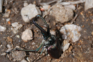 |
| Beetle of the day |
We slept well, at least until it
began to rain heavily around dawn. We rolled
over and slept for another hour until the shower passed, then got up to lovely
dawn light on the lake and the cliffs beyond.
Breakfast, on the campground picnic tables, was enlivened by the cat,
who showed up to chase birds unsuccessfully around the bamboo thickets. We had some of our standard oatmeal, with
lots of candied orange peel, raisins, walnuts and cinnamon to spice it up,
along with lots of toast made over the camp stove. We waited for the tent and fly to dry, then
set off around 11, with our departure delayed by a search for the hook from
Terri’s bungee cord that got wrapped around her axle and popped off. An amazing beetle on the driveway delayed us
further as I tried to get decent photos of its green iridescence and massive
horns. Once we finally got underway, the
riding was easy, mostly downhill along a spectacular gorge. Towering cliffs rose above the paved but
deserted road, while dense primary rainforest filled the valley, interrupted by
massive waterfalls. After 32 km, we had
lunch on Laguna Tres Torres beside a burnt-out building that once (we think)
offered boat rides into the Reserva Nacional Maniguales. We continued a few kilometres into Villa
Manihuales, a tiny hilltop town being given an expensive facelift, although it
didn’t seem to be interested in maintaining what infrastructure it already had. The town’s main shops were all closed for
siesta, but we finally found a small shop to stock up.
 |
| Rio Cisnes loveliness |
We had an afternoon beer in the overgrown
main plaza, then rode out of town, up a steep rise and then down, down, down to
the Rio Cisnes, yet another beautiful azure river through dense forests,
magical mountains and thundering waterfalls.
On the way downhill, we paused for photos and to say hello to a
procession of cycle tourists making their way laboriously uphill, heading south. We rode a bit further along the river, paused
for chocolate to restore Terri’s will to cycle, and then found perhaps the best
single campsite of the entire cycling trip.
This one was another tip from the Basques: right beside a roadside lookout point, a small
path led down towards the banks of the Rio Cisnes where, behind some dense
bushes, a small beach provided a perfect hidden spot, out of sight of passing
cars.
 |
| Terri showing off her feat of engineering |
It did slope noticeably, but Terri
engineered a solution using some driftwood to create a retaining wall and then
building up a sand platform for the tent.
It worked like a charm, and it was an amazing place to spend the night,
surrounded by rushing emerald waters on one side and a bird-rich bamboo thicket
on the other. Fish leapt from time to
time in search of insects, while the sound of the water drowned out whatever
traffic sound there was. We cooked up
our last pack of dehydrated roesti (hash brown potatoes), topped with onion and
egg, and sipped our Gato Negro sitting on a piece of driftwood beside the river. It was absolutely idyllic and reminded me of
hiking in Sumatra, Indonesia many years ago.
 |
| Our wonderful campsite beside the Rio Cisnes |
Wednesday, December 30, 43.4 km:
Rio Cisnes to the Ventisquero Colgante junction
 |
| Morning beside the Rio Cisnes |
For once it didn’t rain
overnight, and we slept deeply on our perfectly level sleeping surface. We woke up to a deafening dawn chorus of
birds, including a call that we had heard many times but never associated with
a visible bird. When we heard the song
right outside the tent, we opened the fly and were confronted with a
chucao tapaculo hopping boldly around the tent, in and out of the dense
underbrush. It’s described in our bird
book as “often heard but difficult to see”, but this guy was so unafraid of us
that at one point he hopped right between Terri’s feet as she brushed her
teeth. We cooked up some oatmeal,
spotted another new bird (the striped woodpecker) and headed up to the lookout
by 9:10, ready for an earlier-than-usual departure.
 |
| Water-sculpted rocks in the Rio Cisnes |
It was not to be. I still had to fix Terri’s back brakes, and,
armed with the wisdom of a few YouTube videos, I thought I was ready. I wasn’t; I managed to remove the old brake
shoes, but then managed to push the brake pistons right out of their housing,
spilling lots of brake fluid in the process.
We put a bit of mineral oil that I had for the stove into the hydraulic
system to replace the loss, but the brakes wouldn’t work at all; there were air
bubbles in the brake lines that needed to be bled, and neither of us knew how
to do it. Passing tourists gave us
advice, but nobody had any spare brake fluid.
We eventually pedalled off, spotting lots of chucaos and even a male
Magellanic woodpecker in the dense forest along the road. A few kilometres down
the road, just at the turnoff where the Carretera turns away from the pavement,
we stopped at a road maintenance crew’s camp.
Reasoning that someone there would both know how hydraulic brake systems
work and would have some hydraulic fluid, we asked for help. Sure enough, the crew’s mechanic came out,
took a bit of hydraulic fluid from his truck’s reservoir and methodically bled
the bubbles out of the brake line. By
the time we pedalled off, Terri’s brakes were working better than they had ever
done, and we even had a small supply of extra fluid just in case. We thanked our do-it-yourself saviours
profusely and rode off up the rutted gravel.
 |
| The road crew guys who expertly fixed Terri's brake system |
We spent the next couple of hours
climbing quite a long way uphill over the Cuesta Queulat. This section of road will be the next part of
the Carretera to be paved, and our friendly road crew were working on getting
the road ready for asphalt by widening it and re-engineering the drainage and
the road bed. There were sections of
soft gravel, or of steep bypasses around construction zones, but the climb
itself wasn’t too bad, at about 500 metres of elevation gain. We were heading towards a well-known national
park,
Queulat, known for its population of huemul deer, and the scenery was
appropriately majestic, with dense temperate rainforest, thundering waterfalls,
abundant birdlife and views of distant hanging glaciers.
 |
| More jungle waterfalls, Parque Queulat |
At the top there was a parking lot for a
muddy hike to the foot of a glacier. We
elected not to walk, as the views and wildlife were plentiful from the
road. A couple in a rented car offered
us leftover chicken sandwiches from their hotel packed lunch which we gobbled
down gladly, and we talked to the passengers in a German overland truck (a
ro-tel, or rolling hotel) for a while about their journey.
Eventually we set off
downhill. The road improvements stopped
at the top, and the descent was on a steep, narrow track that switchbacked down
a precipitous slope. It was just as
well that Terri’s brakes were back in working order, as we were riding the
brakes all the way down. Eventually we
found ourselves at the bottom of a deep, forested valley and followed the Rio
Queulat downhill to the ocean, where the Queulat fjord made for a dramatic
backdrop to the road. We looked for
places to camp, but they were few and far between, with estancia fences and
steep cliffs limiting our choices severely.
 |
| Terri cycling through Parque Queulat |
The road surface was particularly awful, far worse than the ripio we had ridden on further south, so
it wasn’t much fun bumping along in search of a place to sleep.
In the distance, a dramatic hanging glacier,
the Ventisquero Colgante, loomed large above the road. At a road junction where a side road heads
toward the glacier, we spotted a small commercial campground and settled in for
the night. They were renovating an old
campground, and that very day a backhoe had come in and uprooted vegetation,
leaving the site looking a bit like the Somme in 1916: fallen branches, muddy puddles and general
destruction. It was ironic that after a
day of cycling through sublime beauty, we were camped in the ugliest spot we had
seen all day. Still, there were shelters
against wind and rain for us to pitch our tent, and our showers were hot and
welcome. A meal of pasta, a beer and a
failed attempt at a campfire and we settled down to a refreshing night’s sleep.
 |
| Hanging glacier above Parque Queulat |
 |
| Ventisquero Colgante |
 |
| Terri cycling along the Queulat Fjord |
Thursday, December 31, 21.9 km:
Ventisquero Colgante junction to Puerto Puyuhuapi
We had a very, very relaxed day
on the last day of 2015. We rolled along
the coastal road, looking across the fjord to the wild country beyond, past a
couple of salmon farms for about 14 km to a destination that had been on our
radar screens for a few days:
the Termas de Ventisquero, an upmarket hot spring complex on the shores of the fjord. When we arrived, there were only 2 other
guests, and, paying the excessive pricetag (18,000 pesos, or about US$ 25) we
settled into the hot pools for a few hours of warmth and blissful relaxation,
two things that had been missing from our lives for a while. The views were pleasant, looking out towards
the exclusive hot spring resort on the opposite shore and to the rainforests
beyond. The grounds were well maintained
and full of birds including a kingfisher.
We wallowed in the hot water like a couple of dugongs for almost three
hours before getting dressed reluctantly and cycling the 7 km into Puyuhuapi
town. On the way I had another flat
tire, and sent Terri on ahead to scout around town. Unlike my experience on the shore of Lago
Carrera, this was a quick and painless repair job. Once I got going, I ran into a British/Aussie
couple on bikes who had cycled down from Alaska in 17 months, and spent some
time swapping stories from the road and tips on where to camp.
 |
| Brendan outside Hostal Evelin |
In Puyuhuapi, a small,
neatly-tended town founded by Sudeten Germans in the late 1930s, I found
Terri’s bike outside a grocery store.
She brought me beer and potato chips and pedalled off to run errands
while I chatted with a young American, Brendan, who was cycling south. Terri returned with the news that we were
going to stay in town to celebrate New Year’s Eve and that she’d found a good
place to stay, or at least the cheapest place in town, Hostal Evelin. Brendan came with us, and at Evelin we ran
into another guest, Joseph, a very interesting guy from Hong Kong who had
worked in the Democratic Republic of Congo for years. Terri and I did some laundry and then went
out for a great fish dinner before returning to Evelin for a bottle of
celebratory Chilean bubbly and a long chat with Joseph. We were unable to keep our eyes open past 10
o’clock, so we missed the start of the new year; this is probably the sixth or
seventh time in the past 15 years that I haven’t been up at midnight for the
turn of the year. The rest of the town
was out partying, however, which made for a less-than-restful sleep.
Friday, January 1, 65.0 km:
Puerto Puyuhuapi to Puente Exequiel Gonzalez
 |
| Terri riding beside Lago Risopatron on New Year's Day |
New Year’s Day found us pedalling
north, full of bacon and eggs and toast, under blue skies and warm conditions,
although persistent headwinds spoiled the perfection of the day. We bumped uphill out of Puyuhuapi and then
undulated along the shores of long, narrow Lago Risopatron. The ripio
was once again unspeakably bad, but at the end of the lake we picked up brand
new asphalt that would last all the way to La Junta. It was the warmest day of the entire trip so
far, with temperatures in the upper 20s, and by the time we got to La Junta we
had worked up quite a hunger. We had a
sumptuous lunchtime feast in La Junta’s pretty municipal park of bacon and
cheese sandwiches, along with slices of avocado, and then more bread with
peanut butter, all washed down by delicious Finisterra craft IPA beer.
 |
| Scenery near La Junta--beautiful views, horrible road surface |
We rode out of La Junta and back
onto abysmal ripio, the worst we had
yet seen, almost impossible to ride. At
least when we looked back we had the beautiful distinctive two-horned summit of
snow-capped Volcan Melimoyu to take our mind off the horrorshow of the
road. There were several welcome
stretches of asphalt, but they were all brief teasers. It took us a good deal of searching to find a
good campsite, and we rejected a roadside meadow that probably would have been
ideal but which involved a long slog downhill to reach. Eventually a bridge came to our rescue again,
as we camped at the far end of a bridge (the grandly named Puente Senador
Exequiel Gonzalez) over the Rio Palena, yet another rushing teal-coloured
stream. The family living nearby had no
problem with us camping, and we went down for a dip in the river before cooking
up a huge stew of lentils, pumpkin and potato.
I played guitar in the evening, getting a bit maudlin over the beauty of
the day.
Saturday, January 2, 48.8 km:
Puente Exequiel Gonzalez to Villa Santa Lucia
 |
| We like seeing this sort of change in road conditions! |
After a great first day of
2016, the following day was much more trying. Terri awoke feeling unwell, and I awoke
early, did some birdwatching and diary-writing and then retreated into the tent
to escape rain. It wasn’t until after 9
that we got up with the rain continuing, moved stuff under the shelter of the
bridge and cooked up breakfast there. A
striped kingfisher hunting for prey beside the river was one of the few
highlights of the morning. Finally,
having partially dried our wet tent and fly, we made a getaway at 11:45 with
Terri still feeling awful. We made
agonizingly slow progress up the valley on ripio,
but just as we were giving up hope of getting anywhere, right at the border
between Region XI and Region X, asphalt appeared beneath our tires. I felt like kissing the pavement pontifically
from sheer gratitude.
From then on we
made better progress, although Terri still had no energy and ended up pushing her
bike up a lot of the small, steep hills.
It continued to spit rain on us, and the landscape looked less majestic
than it should have under leaden skies. Cookies
and leftover Christmas cake, then peanut butter on bread, were consumed beside
the road in an effort to jumpstart Terri, and eventually she felt better and
made further progress. We rolled into
the scruffy junction town of Villa Santa Lucia around 5 pm and, after lots of
indecision about what to do and where to stay, ended up taking a well-equipped
but expensive cabana behind a grocery store.
We shared the expense with a Belgian couple cycling the other direction,
Jan and Vera, and had a wonderful evening cooking up chicken and potatoes,
eating more leftover lentil stew and swapping stories from the road. We realized, talking to them and to other
cyclists along the road, that we were now within sight of the end of our
Carretera Austral journey.
Sunday, January 3, 55.0 km:
Villa Santa Lucia to El Amarillo
It was a good night to be
indoors, as a torrential downpour hammered down on our roof most of the
night. We had a good feed of oatmeal,
eggs, cocoa and tea before setting off at 10:30 under bluebird skies. We had one last big climb in front of us,
gaining 400 metres over 8 km of bumpy ripio.
Terri had recovered from the previous day’s indisposition and rode
strongly. The rain had given way to blue
skies and warmth, although we still had the wind in our faces. We bumped steeply downhill into the valley of
the Rio Yelcho Chico and the road surface improved markedly, allowing us to
coast along downhill at a decent clip.
In the distance the waters of Lago Yelcho glittered invitingly. As our road approached the end of the lake, a
series of landslides had wiped out the track, leaving steep, muddy slogs to
navigate on our bikes. Then, suddenly,
we crossed a striking bridge over the Rio Yelcho into Puerto Cardenas and the
road turned to pristine asphalt. As we
had decided to take the ferry to Chiloe from Chaiten rather than continue up
the last part of the Carretera, we had now officially finished the last stretch
of ripio of the entire trip. Given that each successive gravel section had
been worse than the previous one, it had been an easy choice to take pavement
and beaches on Chiloe over ripio and
pristine rainforest along the Carretera.
 |
| Cycling into Parque Pumalin, near El Amarillo |
There was no shop in Puerto
Cardenas, so we were without bread for lunch.
We rode a few kilometres to a very pretty river and cooked up instant
mashed potatoes which we consumed with sardines and cheese: not haute cuisine, but plenty tasty under the
circumstances. We then ground our way
along the almost-deserted road, battling headwinds the entire way, to the
village of El Amarillo. Terri rode
harder and faster than she had for almost the entire trip, as her body finally
seemed to be adapting to the rigours of the Carretera. At El Amarillo, we realized that we were on
the edge of
Doug Tompkins’ Parque Pumalin, and turned off into the park to camp
at Camping Carlos Cuevas.
 |
| Terri dwarfed by gigantic gunnera leaves |
The park,
created from old estancias that Tompkins had bought up to conserve the forests
from logging, was perfectly manicured.
The village was noticeably neater and more prosperous-looking than the
towns we had been in recently, testimony to Tompkins’ determination to involve
the local population in conservation and to improve their lives. To the north the impressive bulk of Volcan
Michimahuida caught the late-afternoon sun, while all around primary rainforest
sounded with birdsong and the electric hum of cicadas. We put up our tent and went for a walk
through the forest, past immense leaves of gunnera, a plant whose leaves look
like gigantic rhubarb. It was absolutely
idyllic. We cooked up macaroni and
cheese, drank some Gato Negro and chatted with a couple of Dutch students, one
of whom was living in Santiago.
Monday, January 4, 28.4 km:
El Amarillo to Chaiten
 |
| On the beach at Chaiten |
We awoke to rain on the tent the
next morning, just as the dawn chorus of birdsong kicked off. We rolled over and snoozed for an hour,
hoping (in vain) that the rain would end.
Eventually we got up and cooked under the roof of the campground cooking
shelter. We had to put the tent away
soaking wet. We cycled through improving
weather, aided by improbable tailwinds, for 27 quick kilometres to the coast at
Chaiten. Terri was full of energy and
would surge ahead for brief sprints at 29 km/h before dropping back and letting
me push ahead at a more sedate 24 km/h.
We were in town in not much over an hour, looking for a place to
camp. We stopped in at Las Nalcas
campground where Melanie and Vincent had left the USB thumb drive that I had
inadvertently left behind in Coyhaique.
They were only a day ahead of us, but we hadn’t crossed paths with them,
or with Silke or Ralf, since Christmas.
Las Nalcas seemed crowded and overpriced, so we went around the corner
and camped at Trekapangui. We set up our
tent to dry, then went out for a wonderful lunch of churrasco sandwiches. We bought tickets for the next day’s ferry to
Quellon, the port at the southern end of the island of Chiloe, then went for a
walk along the long, broad beach of Chaiten, littered photogenically with
driftwood and full of interesting birdlife.
That evening we cooked up a huge lentil stew and chatted with Camille,
an older Swiss guy, and Emma and Dave, a couple of young Canadian treeplanters.
Tuesday, January 5: 19.9 km,
Quellon to campsite on Rio San Antonio
 |
| Volcan Corcovado and the Yanteles range |
Although we didn’t know it, we
had experienced the last rain of our trip in Chile. We awoke early to a tent soaked with dew (it
had been a distinctly chilly night) and after a hurried breakfast we were in
line for the ferry by 9:15. We needn’t
have hurried; the ferry was late arriving, and we were one of the last people
onto the boat as they loaded the vehicles first. We sailed out at 10:15 and had a great trip
across the Gulf of Ancud to the island of Chiloe, the second-biggest island off
the coast of South America (after Tierra del Fuego). The sky was clear, the sun was hot and the
views were epic. Looking back towards
shore, we could see Volcan Michimahuida towering over the coast, with the
smaller Volcan Chaiten and the tiny Cerro Vilcun making up with ominous smoking
menace what they lacked in size. To the
south Volcan Corcovado dominated the skyline, with the Yanteles range and our
old friend Volcan Melimoyu standing out much further to the south.
 |
| Cerro Vilcun gently smoking away in the morning sunlight |
We sat on the top deck admiring the view and
reflecting on the great adventure of the Carretera Austral. We put into Quellon, a bustling medium-sized
city, at 2:40 and went straight into a dockside restaurant for a seafood feast: merluza
(Patagonian toothfish, aka Chilean sea bass) for Terri and chupe de locos (a sort of bread pudding made with “Chilean
abalone”, a shellfish found only on the west coast of South America) for
me. It was delicious, and marked our
survival of the wilds of southern Chile and our arrival in the more densely
settled parts of Chile.
We had heard that there was a
possibility to see blue whales in the waters off Quellon, so we went off to the
tourist information office to ask about it.
The office had moved and was hard to locate, and wasn’t really worth the
effort as the staff had no real idea about anything on Chiloe. We gave up on whale-watching, stopped in at a
huge Unimarc supermarket, and finally got going at around 5:30. We had a nasty climb out of town accompanied
by lots of traffic, but once we were up on the inland plateau, traffic eased
off and we rode along in the late afternoon light looking for a campsite. We looked down a sideroad without any luck,
but then the next sideroad, 20 km from town, provided access to a surprisingly
idyllic campsite. We had to wade across
a stream twice, but it gave access to a big riverside meadow. We put up the tent and watched birds flying
and swimming by: raucous groups of
austral parakeets, yellow-billed pintails, cinclodes, duicons and
elaenias. Leftover lentil stew, served
up with more tomatoes and potatoes, sent us to bed well-fed and content.
Wednesday, January 6, 76.1 km:
River campsite to Changuin
I didn’t sleep well: we were dripped on by dew soaking through the
fly. It was clear that our fly was
losing its waterproofness, so we decided to buy some waterproofing spray when
next we were in a town. We had a relaxed
morning, cooking up scrambled eggs and toast before setting off at 10:30. We actually had fairly strong tailwinds and
quite flat topography for the first 20 km, before reality set in in the form of
a series of short, sharp climbs and descents.
It was a scorching hot day, and we had our first run-in with the dreaded
tabanos, the nasty orange horseflies
that plague Chiloe in the summer. They
love the heat, and when our speed slowed down on uphills, they circled round us
tirelessly, looking for a chance to land and bite. After 30 km we stopped and had a snack break,
scarfing down empanadas and an apple and quaffing a radler,
the drink that powered our Danube bike trip back in June. After 44
km we turned left onto the side road that led to the Pacific coast and
Chiloe National Park, just in time for Terri who was wilting in the heat and pushing her
bike uphill, and who was being driven to distraction by the horseflies. We had a wonderful lunch beside the road not
long after the turnoff: hard-boiled
eggs, avocado, tomato and cheese with bread.
As we got to Lake Huillicho, we ran into stiff headwinds that lasted
most of the way to Changuin. Terri found
the relentless roller-coaster of a road too much to bear, and when we stopped
beside the lake to take a break and look at birds, she was driven away by a
swarm of horseflies and cycled off at supersonic speed.
We made our way out to the coast
at Changuin, settled into an idyllic and almost deserted campground and had a
meal of empanadas. The view out over the
lake was perfect: reed-lined shores,
lots of birds, a few passing kayakers and distant forested hills. We tried to walk out to the ocean at sunset
but got lost and strolled back home in the dark.
Thursday, January 7, no cycling:
In and around Changuin
 |
| Otter in the river at Changuin |
Chiloe occupies a special place
in the hearts of Chileans. It was the
southernmost part of the country that was settled under the Spanish, and
developed a distinctive folklore, musical style and wooden church architecture
(
the churches are now recognized as UNESCO World Heritage sites). Most Chilotes live on the eastern side of the
island or on small offshore islands in the archipelago, fishing in the
protected waters of the Gulf of Ancud.
The west coast, exposed to the winds and swell of the open ocean, is
much less settled and has remained largely undeveloped, and is now protected by
the Chiloe National Park. We had taken
this sidetrip in order to do some hiking and exploring in the national
park. We got up early and wandered from
our campground into town in search of food and (strangely) water; our
campground had had a problem with its water pump the previous day and had no
running water. The owner was in the island’s
main town, Castro, trying to get the pump fixed. As we walked over a road bridge, we looked
down and saw an otter contentedly diving to the bottom of the river to dig up
mussels, and then returning to the surface to lie on his back, crack open the
shells and eat them. Terri had never
seen an otter before and was captivated.
 |
| Terri on the beach at Changuin |
After breakfast we spent much of
the day walking around the national park.
There were several short trails near the park entrance, and the tepual trail, through remnants of the
distinctive lowland marsh forest of Chiloe, was our favourite. Layers of fallen tree trunks, vines and
bamboo covered the ground and provided a rich habitat for birds and
orchids. We walked along another trail,
had lunch, and then headed out to the beach.
 |
| Me on the beach at Changuin |
The views were great, the light glinting off the surf was dramatic, and
it was wonderful to be in the ocean, but the tabanos were insufferable.
As soon as we got onto the hot sand, we were mobbed by dozens of hungry
buzzing orange horseflies. Only by
wading out into the water could we escape.
Eventually, though, we realized that people who lay perfectly flat on
the sand to sunbathe were the only people not swatting madly at the air. It seems as though tabanos don’t like to attack too close to the ground, or under a
roof. We walked along the beach to the
mouth of the river, where cormorants and gulls clustered to feed on fish which
in turn were fed, ultimately, by minerals and micronutrients carried by the river
water. The flies eventually got to us
and we retreated back to our campground for cold beers and lentil stew. I spent time playing guitar, watching the
light play across the lake and spotting birds in the water and in the bush; new
birds included the diuca finch and the striped bittern. We went to bed happy with our day off the
bicycles.
 |
| Mist rising over the beach at Changuin |
Friday, January 8, 80.6 km: Changuin to campsite near Mocopulli
 |
| The wooden church at Nercon |
Terri hadn’t enjoyed the ride to
Changuin (despite the lack of traffic) and wasn’t keen to repeat it, so she
decided to take a bus to the big city of Castro while I rode my bike there to
meet her. It was a great day for bike
riding, with tailwinds blowing inland from the coast. I averaged 20 km/h all the way back to the
main road, and then slowed down noticeably once I turned north on the traffic-clogged
main road and hit a series of hills. It
was scorching hot again, and I stopped for cold drinks, raisins and bananas
near the town of Chonchi. I rode through
heat and traffic to see
Nercon, one of the UNESCO wooden churches (somewhat
underwhelming, although pretty enough) and then into downtown Castro, a scruffy
and down-at-heel city, where I found the bus station and settled down to wait
for Terri. When she arrived, we stopped
in at a shopping mall to buy some waterproofing spray for the tent fly, then
had delicious churrasco sandwiches and stopped in to see the pretty wooden
Castro cathedral before riding out of town.
It was a grim slog out of town in intense traffic, past endless
stretches of industrial development. We
thought that we wouldn’t find a place to camp, but luck was on our side as we
found a perfect spot just off a sideroad near the town of Mocopulli. In a patch of forest, a field had been
cleared for a soccer field and barbecue spot, but nobody was there, so we put
up our tent, cooked up supper and slept soundly.
Saturday January 9, 62.4 km:
Campsite near Mocopulli to Ancud
 |
| Celebratory beer and mountainous curanto |
Our final day of cycling in Chile
was distinctly anticlimactic. We got
away by 9:20 (the earliest in a long, long time) and charged into Ancud aided
by tailwinds and (mostly) flatter roads.
After 20 km we stopped for a snack to escape from the infuriating
horseflies and had the best churrasco sandwiches of the trip in a little
roadside diner. After that we just rode
to survive, buffeted by dozens of passing trucks and attacked by tabanos. Terri pioneered a good form of defense,
carrying a bundle of reeds in one hand to wave around her as a fly whisk on the
uphills. By 2:15, after a surprisingly
quick ride, we were in the town of Ancud, headed down to the harbour for a
celebratory end-of-cycling lunch. Terri
had a memorable salmon steak while I went for the Chilote specialty of curanto, a huge mass of fish, shellfish, chicken and pork that even I had difficulty
in finishing. We had a bottle of
celebratory bubbles, then wobbled a long way back from the shore to the bus
station to buy bus tickets to Santiago.
As it was the height of the summer tourist season, we couldn’t get
tickets for the next day and had to settle for a ticket for the night of
January 11th. We looked
around for a place to stay and ended up almost next to the bus station at the
Hospedaje Austral, run by the irrepressible Mirta. We had empanadas for supper and retired to
bed early.
We had been riding our bikes
since November 19th, so a total of 52 days, including days off the
bike. We had covered 1575 kilometres,
including 1245 km since leaving El Chalten and 1180 km since riding out of
Villa O’Higgins 26 days earlier. We had
ridden through a series of dramatic landscapes, past huge lakes and limpid
blue-green rivers, under glaciers and past vast thundering waterfalls, along
one of the great adventurous bike routes of the world. It had been a great adventure, even if Terri
found it a bit more challenging at times than she would have liked. We had camped in beautiful wild camping spots
all along the route, cooked up memorable meals and drunk toasts alongside
rivers and beside lakes. It had been a
wonderful bike trip which had been on my mental radar for 15 years, and now it
was over. Now it was time to move onto
the next phase of our South American adventure.
Sunday, January 10-Friday, January 15, no cycling: Ancud, Punihuil and Santiago
 |
| Happy to be done cycling, near Punihuil |
 |
| Magellanic penguins |
We spent the next day as we had
spent the beginning of our South American/Antarctic trip: watching penguins. We booked a tour out to the penguin rookeries
outside Ancud at the village of Punihuil and shared the ride out (about 25 km)
with a couple of young Chilean women who were visiting from Valdivia for a long
weekend in Chiloe. The colony featured
both Magellanic and Humboldt penguins; we had only seen the first species
briefly on the ferry from Tierra del Fuego to the mainland, and never seen the
second.
 |
| Humboldt penguins |
Punihuil is a big tourist spot,
with lots of boats heading out to see the penguins, but it seems to be well
regulated and well run, and the birds (not just penguins, but lots of
cormorants and other seabirds) aren’t hassled and are left to their own devices
for the most part. We had a great boat
trip, followed by a delectable seafood lunch, before heading back to Ancud. It seemed a fitting close to our southern
adventures.
 |
| Flightless steamer ducks, Punihuil |
 |
| Terri, Paola and I and the wonderful apero prepared by Terri |
We spent the next day loafing
about in Ancud, waiting for our bus to Santiago, and then three days in
Santiago visiting old friends of mine from my 6 months of working in Santiago
in 1999. It was great to see them all,
and to see Santiago, which has grown hugely in area since I was there. We spent two nights sleeping at my friend
Paola’s place out in Chicureo, a sprawling California-type suburb of detached
bungalows that could be anywhere in the rich world, and our last night sleeping
at a dismal flophouse near Santiago’s main bus station so that we could catch
an early bus the next morning. The
contrast between the two neighbourhoods was striking. We spent a late afternoon and evening
wandering downtown Santiago and Cerro Santa Lucia with my friend Natalie,
admiring the rare clear-sky view of Santiago’s surrounding mountains, and had
another evening out in the hip neighbourhood of Bellavista with my old tennis
partner Nico. And then it was time to
get onto a series of buses to take us across northern Argentina to Asuncion,
Paraguay and the next main instalment of our South American trip. I was sad to be leaving Chile, but excited to
be seeing new countries.
 |
Natalie and Terri atop Cerro Santa Lucia
|