Biscione, October 23, 2020
I am sitting here in western Sicily, in a little rented house near the Mediterranean (our latest hideout from covid-19), trying to catch up on months of projects left undone. It's a good spot to update this blog with another retrospective post from almost exactly a year ago, when Terri and I spent my fall break from school on a road trip around Armenia and Nagorno-Karabakh. With Nagorno-Karabakh
very much in the news these days given the
fierce fighting there, it seems a good time to look back on a more peaceful period in that troubled part of the world.
Terri and I
had visited Armenia together very briefly in 2018, on a November long weekend, but we had only nibbled at the very northernmost bit, the churches of the Debed Canyon. I spent
several weeks in Armenia, with a
brief visit to Stepanakert, the capital of Nagorno-Karabakh, on my Silk Road bicycle trip back in 2009, but there was much of the country I hadn't seen, and I was keen to reacquaint myself with the abundant historical and cultural sights of Armenia. We had spent the previous year's fall break
exploring the breathtaking beauty of Georgia's Svaneti region, and now we were keen to set our sights slightly farther afield. Travelling in Douglas, our trusty Mitsubishi Delica 4x4 van, we were confident that we could get just about anywhere, and camp in comfort in the wide-open spaces of the countryside.
We set off early on Saturday, October 19th, driving through the quiet early-morning streets of Tbilisi and then out of town to the south. The Armenian border crossing at Sadakhlo is only an hour's drive south of the city, and it always amazed me how few of my Georgian students and friends had ever crossed into their neighbouring country. A lot of that, I think, can be attributed to the mutual dislike between Georgians and Armenians, with
anti-Armenian sentiments and bigotry fairly widespread among Georgians and (I assume)
the converse being true in Armenia. The fact that the
Armenian Apostolic Church is monophysite (or, more precisely, miaphysite) and hence not Orthodox lends a certain amount of religious antagonism to the rivalry, as both sides regard the other as being somewhat heretical.
At the border we ran through the usual border formalities, bought temporary car insurance for the equivalent of US$ 10, and had our first delicious meal of
khoravats, the grilled meat for which Armenia is justly famous. We then drove further into the country, close to the Azeri border, towards our destination for the day, the mountain resort of Dilijan. Looking at the map now as I write this, I realize that the road passed across a small area of Azeri territory, but it's part of three villages in Azerbaijan (the former enclaves of
Sofulu and
Verin Voskepar, as well as the border region of
Nerkin Voskepar) that have all been occupied by Armenia since 1992, during the bitter Nagorno-Karabakh War. I'm not sure where the new effective border runs, but it must be very close to the road; I wonder if the recent fighting has featured attacks on this road?
 |
| Fall colours at Parz Lake |
After a few hours of driving, we dropped into Dilijan. This is one of the premier tourist towns in Armenia, a mountain resort a bit reminiscent of Kazbegi in Georgia. The fall colours were approaching their maximum in the forests around town, and the scenery was pretty, if not spectacular. We found a place to stay in a small guesthouse, then set off on foot to explore the town. It was a pleasant spot, but had the somewhat forlorn aspect of any tourist town during low season. We wandered around for a while, then settled in for a craft beer in one restaurant, followed by a meal in another followed by an early night.
 |
UWC Dilijan
|
The following day we started off by checking out the international school,
UWC Dilijan, that is located on the outskirts of town. We weren't allowed in by security, but from across the river we admired a modern, extensive and expensive-looking school campus that seemed absurdly out of proportion to the scruffiness of much of the rest of town. The
UWC (United World College) schools are spread around the world and I have colleagues, friends and casual acquaintances who have either worked or studied at quite a few of these schools over the years. They try to make the world a better place and promote international understanding, and that, in the Caucasus region, is something that is sadly needed!
 |
A late-season amphibian at Parz Lake
|
From there we headed out to Parz Lake, a beautiful spot popular with local tourists. We were there early, and it was almost deserted. The fall colours in the hardwood forests around the lake were spectacular, and our hike to a viewpoint above the lake was a good antidote to the long drive the day before. The forest was alive with birds and small frogs. We looked north across a river valley to a series of jagged peaks in the Lesser Caucasus range. Our hiking route was really well marked, like trails in Switzerland or France, testament to the influence of the Trans-Caucasian Trail organization, who are based in Armenia and are dedicated to developing a long-distace hiking trail like a European GR route running from the Armenian-Iranian border to Svaneti in Georgia. We discussed coming back to Armenia in the summer of 2020 to hike a long segment of the TCT, as seems to run through really scenic, historically interesting regions. (Obviously this didn't happen!)
 |
| Terri above Parz Lake |
When we returned to the car after a few hours of hiking, the lake was busy with late-arising Armenian tourists and we made a hasty exit. A couple of hours of scenic driving brought us over a pass (more fall colours) and down into the somewhat bleak basin of
Lake Sevan. I had not visited the lake on my bicycle in 2009 because of a broken pedal, but it did not seem as though I had missed a great highlight of the country. The scenery was somewhat austere, with few trees and a searching wind blowing across the water. Here and there a church perched on a knoll above the lake, but the main impression of the manmade structures was that they were decaying Soviet-era concrete. Armenia was hit hard by the collapse of the USSR, and many towns, including Sevan, look like post-Soviet apocalyptica. We drove on southeast along the southern shore of the lake, and eventually found a nice place to camp, in a deserted summer campground used, apparently, just for a summer music festival. The pine trees sheltered us from a scouring wind, and we set up Douglas for a night's sleep and cooked up a delicious meal in blissful solitude.
 |
Our comfortable camping bed in Douglas
|
 |
The road down into Nagorno-Karabakh
|
We awoke to calmer weather, packed up and continued along the southern shore of the lake, stopping for a spot of birdwatching on the lakeshore in Martuni before continuing past the bleak town of Vardenis. The road climbed steadily away from the lake towards the Sotk gold mine.
Sotk itself was once inhabited by 1000 or so ethnic Azeris, but they fled or were driven out by their Armenian neighbours during the first spasms of ethnic fighting in 1988. The road climbed past the mine to a pass which gave sweeping views to the east, into Nagorno-Karabakh proper. As we descended, we passed out of the legally recognized territory of Armenia proper and into occupied Azeri territory. When Nagorno-Karabakh broke away from Azerbaijan during the 1988-94 war, it was not just territory with a long-standing ethnic Armenian majority that ended up on the Armenian side of the ceasefire line.
Seven districts of territory with a long-standing Azeri majority, home to hundreds of thousands of Azeris, were occupied to the north, west and south of Nagorno-Karabakh itself as a "security zone" linking the isolated territory of Nagorno-Karabakh to Armenia proper. The Azeri inhabitants of these seven districts (some 400,000 or so in number) were ethnically cleansed, ending up as internally displaced persons (refugees) in Azeri-controlled territory. We were dropping into Kalbajar region, all of whose few inhabitants are now ethnic Armenians. We could see a number of deserted buildings scattered beside the road; their former inhabitants were presumably now living somewhere on the other side of the ceasefire line.
 |
| Scenery in northern Karabakh |
We paused for photos, then drove down a steep, slightly alarming road to the Nagorno-Karabakh "border", where we filled out paperwork and were issued with our visas for "Artsakh", the new name for Nagorno-Karabakh. The visas come as stickers which travellers can choose to stick into their passports or not; most people probably don't enter them into their passports just in case they ever want to visit Azerbaijan in the future. We continued downstream along a beautiful wooded valley; Artsakh is a much greener country than much of Armenia, densely forested with oak-hornbeam hardwood forests. The high Armenian plateau descends sharply into the Azeri lowlands here, with a series of sharp ridges. It's a very scenic area, with roads signposted back uphill from time to time, leading to isolated Armenian monasteries high in the mountains. We stopped to see the atmospheric ruins of Surb Astvatsatsin on the riverside, then continued our drive, oohing and aahing over the fall colours and the dramatic topography.
 |
Surb Astvatsatsin
|
 |
| The ruins of Surb Astvatsatsin |
Eventually we stopped following our river and cut across the grain of the land in a series of climbs and descents, heading south towards Stepanakert, the capital of Nagorno-Karabakh. When we finally arrived, it was a bit of a mission to find a hotel in our (low) price range, but we eventually settled in and headed out for a walk. I had been in Stepanakert in 2009, but I didn't remember it all that well, and it took us a while to find a restaurant. The town itself is a bit boxy and post-Soviet, but there has clearly been a fair bit of recent investment, and the streets had a buzz of energy about them. I will be curious to see how much life returns to the streets after weeks of fighting and artillery and drone strikes; accounts I have read suggest that at least half of the population of Stepanakert has fled back to Armenia since the start of fighting in late September.
 |
The cliffs of Shushi
|
 |
| Hiking the Hunot Gorge |
The next day we devoted to exploring a bit of Artsakh by driving the short distance uphill to Shushi, the old fortress town that looms over Stepanakert. We parked the car near the central square and its recently restored mosque (the truncated minarets of another mosque stand picturesquely nearby, decorated with interesting brick patterns), then hired a local taxi driver to take us down to the village of Karintak along a fairly decrepit dirt track. We had read about the Janapar Trail, a 500-km long-distance hiking trail running the length of the territory, and had decided to hike one small segment of it from Karintak back to Shushi.
 |
| Zontik Waterfall |
It was a good choice. The trail led down into a narrow canyon (the Hunot Gorge) below the towering limestone cliffs of Shushi. We walked through beautiful forest, over well-built footbridges and along a path marked at regular intervals with the paint flashes of the Janapar Trail folks. We were alone in a beautiful landscape until we reached the Zontik Waterfall, where water spread out over a Cyclopean moss-covered boulder and fell in a delicate curtain. At this point a few parties of tourists began appearing from the opposite direction, and we made our way against the flow to the ruins of Hunot village. The hamlet had been inhabited for many centuries until Soviet times, but had been abandoned because it was impossible to connect it to a road. Tumbled-down walls, a church, farm fences and a 299-year-old arched stone bridge over the river had all been swallowed up by the encroaching forest, and made for some memorable images.  |
| Ruins of Hunot village |
 |
Terri on a rather precarious bridge
|
From there we climbed up around the cliffs back towards Shushi, entering the lower town and making our way through the back streets into the main square, passing dozens of buildings still in ruins 25 years after the end of the war. Shushi was a majority Azeri town and was the most important Azeri military stronghold during the war, with its commanding heights being used to shell Stepanakert below it. The capture of Shushi in May of 1992 by Armenian forces marked a decisive turning point in the conflict, and resulted in the Azeri population fleeing or being forced out. Today Shushi has been partially repopulated by ethnic Armenians, and the Artsakh government recently finished a reconstruction project, but the town still bears the heavy scars of the war, and
Azeri forces recently attacked the main church, leaving it in ruins. We sat contemplating the vicissitudes of war as we ate freshly-peeled walnuts being sold by an old couple on the main street, then retreated to Douglas for the drive back into Armenia.
 |
Post-war dereliction, Shushi
|
 |
| Ruins and minarets, Shushi |
The road back to Armenian proper is dramatic, and Terri was impressed that I had done it in the opposite direction on my bicycle years ago. It took an hour or so to reach the border, past depopulated ruined villages in the "security zone", and then we were back into Armenia. We had been in Nagorno-Karabakh only 24 hours, but we had managed to see a lot of this fascinating, beautiful and troubled pseudo-country.
 |
Tatev Monastery
|
We drove from the border towards Tatev Monastery, easily the most popular tourist site in this part of Armenia. It lies off the main road in a region of dramatic cliffs and canyons, and to facilitate getting to the monastery, one of the longest cable cars in the world, the
Wings of Tatev, has been constructed to whisk tourists from the tiny village of Halidzor across a looming chasm and up to the monastery. It's not strictly speaking necessary to take the cable car (there is still a road winding its serpentine way down and up across the gorge), but it's a dramatic ride and provides a great perspective on the dramatic scenery of the region.
The monastery is quite impressive perched on its rocky eyrie, but has been largely rebuilt after a huge earthquake in 1931.
It was once the most important university in the medieval Armenian world, and was also the site of the declaration of a short-lived doomed state, the Republic of Mountainous Armenia, in 1921, which was quickly swallowed up by the advancing Red Army and reabsorbed into the Soviet Union. The church architecture was imposing, but my favourite feature, as always in Armenian churches, was the carving: elaborately decorated khachkars (stone crosses) and lovely features on the walls and the wooden doors. We wandered around the site, snapping photos and reading historical signboards, until it was time to catch one of the last cable cars back to the parking lot. We found a small guesthouse and settled in for another feast of khoravats.
 |
Khachkar at Tatev Monastery
|
|
 |
| Karahunj |
 |
Burial chamber at Karahunj
|
The next day we drove off to see one of my favourite historical sites in Armenia, the standing stones of
Karahunj (or Zorats Karer). Standing on an exposed plateau above the town of Sisian are a number of tall standing stones, many arranged in rows or circles and almost all featuring man-made holes drilled through the solid rock that many archaeologists believe served some astronomical purpose. Some have claimed (on fairly speculative evidence) that Karahunj predates Stonehenge by millennia, and that it served both as a physical model for Stonehenge, and that its name was appropriated by the ancient Britons ("hunj" = "henge", in this view). Whatever the case, it's an incredibly atmospheric and photogenic spot, and we spent a happy hour and a half wandering around the site, snapping photos and spotting subterranean burial chambers, before the first tour bus of the day rolled up and disgorged a party of elderly French tourists. One of the highlights was spotting a small, energetic stoat methodically hunting his way through the stones, oblivious to two curious humans observing him from nearby.
 |
Karahunj stoat
|
 |
Karahunj
|
From there, we headed off for our obligatory off-road adventure. Douglas, as a Delica van, is a fully functional 4x4, and a previous owner had the van lifted to provide extra clearance. As such, he can handle almost any rugged Caucasus jeep track, and that was what lay in front of us that day. High above Sisian, at over 3000 metres above sea level, below the summit of a mountain called Ughtasar, a tiny lake is surrounded by ancient petroglyphs, carved by parties of Stone Age and Bronze Age hunters who camped there while chasing ibex and other game. It was a long and tricky drive up a rapidly-deteriorating and really steep track to get to Ughtasar. As always, when the driving got tough, Terri took the wheel, expertly navigating us 15 km up the track while I tried to follow along on the GPS, a process that took a good 2 hours. We gave up just before the final precipitous climb, parking Douglas and walking the final stretch uphill through swirling mist onto a broad plateau with the lake (a tiny pond, really) at one end.
 |
Ughtasar
|
 |
Ughtasar: dancing or fighting?
|
|
Sadly we only had an hour; the afternoon was creeping on and the mist threatened to turn to rain, which would make our slithering descent along the track even more treacherous. It would be a lovely place to camp out on a day with fine weather in midsummer, but now, in late October, the lake was already rimed with ice and it would have made for a very chilly night indeed. Terri drove us expertly down the mountain to asphalt before handing over the wheel to me to find a place to camp for the night. After some map study and a couple of false starts, we ended up camped next to the river just upstream from Sisian in an idyllic glade under impressive "houdoo" erosion features, and having a wonderful evening of food and stargazing with a glass of fine Armenian brandy.
 |
Campsite outside Sisian
|
 |
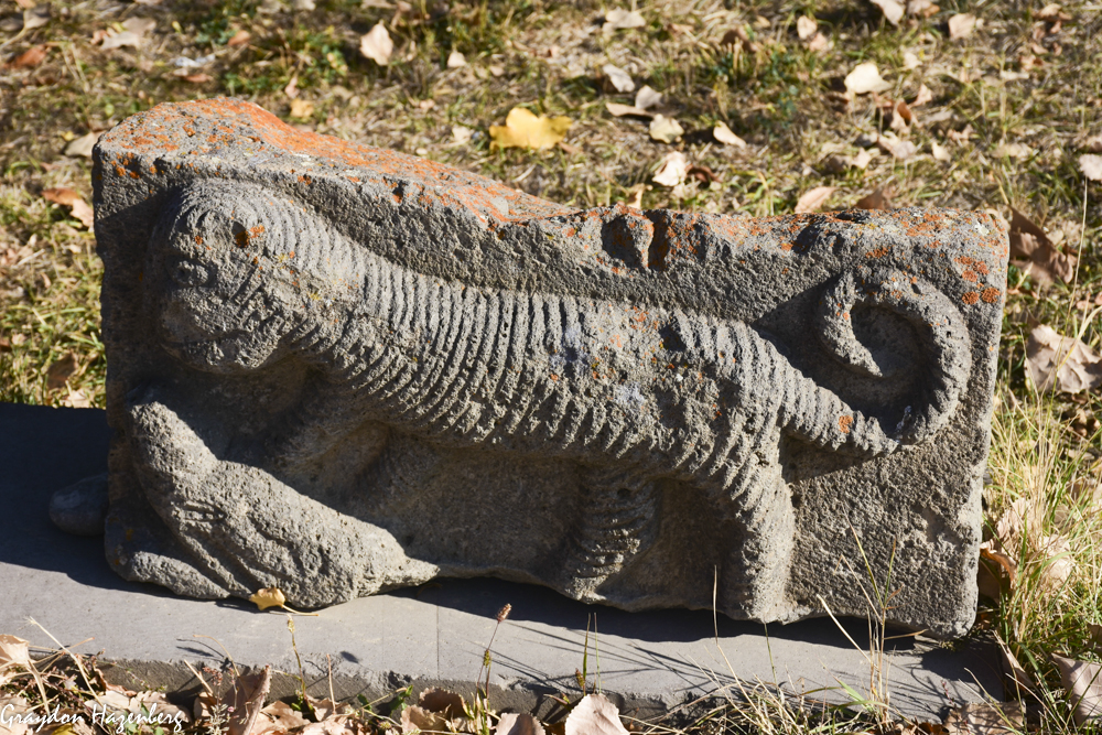
Tiger outside Sisian museum
|
 |
| The view from Areni-I cave |
In the morning, we breakfasted and then drove back to Sisian to check out the rather meagre history museum, whose best features were the petroglyphs and carved stones on display in the museum courtyard, including one that must have represented a tiger (now sadly extinct throughout the Caucasus). We then drove across the epic plateau country northwest of Sisian under painfully blue skies, heading towards Yerevan. We had an obligatory stop, however, at the
Areni-I cave complex, site of some of the earliest discovered evidence of wine production, and had a look around.
 |
The pretty road to Noravank
|
The cave is a major archaeological site, still under excavation, and has produced lots of artifacts and the remains of several humans, as well as stone flakes that Armenian archaeologists believe indicate the cave's use by Homo erectus over 1 million years ago (although that claim is not widely echoed in published work on the site.) The wine production is attested to by pottery qvevri wine jars, almost indistinguishable from those used today in Georgia, from which archaeologists were able to extract traces of grape juice, wine yeast and alcohol, dating back to 4000 BC. Despite claims on the signs in the cave, it's not the oldest wine-making place ever found; there's a site in Georgia which has evidence of wine production almost 2000 years earlier. (Georgians often complain that Armenians always claim to be the first at everything, so they're quite pleased to be ahead on the wine-making front!) It's interesting to note that this area is today one of Armenia's leading wine production regions: plus ça change...! |
| Noravank |
 |
| Noravank |
On our way out of the cave, our attention was captured by an intriguing narrow canyon in the red rock which we decided to investigate. We drove up the road through the gap and found ourselves in a very pretty valley enclosed by steep red walls. Following the road steeply uphill, we ended up at Noravank Monastery, perched in a commanding location high above the river. It ended up being one of my favourite Armenian churches, perhaps because it's constructed of light reddish stone, rather than the rather gloomy and austere black basalt used in much of the rest of the country. It also had some of the more awe-inspiring examples of khachkars I had seen, their delicate stone carving perfectly captured in the late-afternoon light. We lingered, drinking in the views and intrigued by the possibility of coming back in the summer of 2020 to explore some of the longer hiking trails running through the area.
 |
Fabulously carved khachkars
|
 |
| Sunrise light on Ararat |
Then it was time to make tracks, as there was no good place near the monastery to camp. We raced the setting sun across another pass and down to the Araxes river valley, then drove upstream to near Khor Virap monastery to camp amongst the reedbeds below the mound marking the ancient Armenian capital of Artaxata, with views across into Turkey towards a cloud-enshrouded Mt. Ararat, which made for a memorable sunset.
 |
Ararat rising behind the ruins of Artaxata
|
 |
| Terri and Ararat |
The next morning was Friday, which meant that my fall break was almost over, and it was time to start thinking about our route home. We started off the day with a climb up into the archaeological site to catch the early morning light on Ararat, which loomed clear above us, looking so close that it seemed almost possible to reach out and touch it.
Artaxata was the capital of the Armenian kingdom for three centuries starting around 180 BC, and had several distinguished visitors over the years including Hannibal (in exile from Carthage at the end of his life; the story seems a bit fishy, since he was dead before Artaxata was founded, although there's an apocryphal story that he helped lay out the new city during his stay in Armenia), Pompey the Great and Marcus Licinius Crassus. (
Or at least the severed head of Crassus after his catastrophic defeat at the battle of Carrhae in 53 BC; Plutarch records that the head was brought from the battlefield to Artaxata and flung onto the stage at a performance of Euripedes' play The Bacchae, whereupon one of the actors picked it up and extemporized lines to work the head into the play as a prop.) The ruins are extensive but not well excavated or marked, so we wandered about, took a few photos, tried unsuccessfully to identify public buildings, then continued on to Khor Virap monastery just beyond the ruins.
Khor Virap occupies a central place in the history of Armenian Christianity as the spot where the Armenian king Tiridates III imprisoned
St. Gregory the Illuminator in a snake-filled pit for 14 years before Tiridates accepted Christianity in AD 301, turning Armenia into one of the first Christian kingdoms in the world. (Armenians will say that they were the first, but
the kingdom of Osroene has a reasonable claim to having adopted Christianity exactly 100 years earlier; Osroene, however, no longer exists, while Armenia does, so maybe that gives the Armenian claim greater weight. Osroene, around the modern city of Sanliurfa in Turkey, is still a centre for
Syriac Christianity, one of the earliest forms of Christianity and the source of the Nestorians, the far-flung Christian sect that sent missionaries as far east as China by the 8th century AD. I
cycled through the area of ancient Osroene back in 2009, towards the end of my Silk Road bicycle trip.) At any rate, the monastery is a major pilgrimage and tourism site for Armenians, and so we went to pay our respects. The monastery was perhaps a bit underwhelming, but the view from the parapets across to Ararat was spectacular, and Terri was very pleased at having had such a good view of this famous peak.
 |
Zvartnots Cathedral
|
From Khor Virap we drove along the Arax valley, through a series of rather dismal post-Soviet post-industrial towns surrounding Yerevan. We stopped in briefly at the ruins of Zvartnots cathedral, a once-imposing church of monumental scale that fell down (probably in an earthquake) in the 10th century after its 7th-century construction. The remaining pillars are imposing, but don't warrant a prolonged visit. From there we proceeded along increasingly poor roads towards a museum that I remembered fondly from my visit in 2009, at the archaeological site of Metsamor. The site was an important Bronze Age trading city, but sadly the best part of the museum, the spectacular gold treasure, was not open to visitors.
 |
| 1700 years since Armenia's conversion |
Frustrated, we drove back into nearby Echmiadzin, the centre of the Armenian Apostolic church, and found a room at a guesthouse. We walked over to have a look at the Mother See of Holy Echmiadzin, only to find it too was locked and not open to visitors thanks to a major restoration project. Instead we caught a marshrutka into Yerevan and spent the afternoon wandering the streets and shopping for fine Armenian brandy before having a fancy dinner. As we sat in endless traffic in our minibus on the way back to Echmiadzin, we were both pleased with our decision not to drive into the city.
 |
Karmravor church
|
Saturday morning dawned bright and sunny, and we spent the day driving north towards the Georgian border, past some spectacular churches with equally spectacular names like
Karmravor,
Hovhannavank and
Saghmosavank, perched on the edge of a deep canyon worn by the Kasakh River into the lower flanks of the volcanic peak of Aragats. It was good to renew my acquaintances with these masterpieces of Armenian architecture after a decade's absence, before finally turning ourselves definitively away from Armenia and starting the long drive home. It was a spectacular drive over the Spitak pass, with sweeping views of the four peaks of Aragats; only the usual kamikaze post-Soviet driving style could dampen our enjoyment. We stopped in the town of Petrovka for one final feast of
khorovats and had the best example of the art we had yet tasted. The owner of the restaurant said that he had grown up in Tbilisi, but had left after the breakup of the Soviet Union and moved to provincial Armenia because "there is no future for Armenians in Georgia". We contemplated this as we savoured the exquisitely grilled lamb, then said our goodbyes and crossed back into Georgia at a different minor border post where we were the only vehicle during the half hour it took to process our paperwork for the car.
 |
Hovhannavank church
|
 |
| Saghmosavank church |
Back in Georgia, the road deteriorated into something resembling the Ughtasar track, and it took us hours to bump our way to the outskirts of Patara Dmanisi, where we found a spot in the woods to camp. As we cooked and ate, unearthly howling and yipping came from the bushes nearby, a sound that we later figured out was from a family of
golden jackals; it brought us back to the sounds of camping in the African bush in Stanley!
 |
The peaks of Mt. Aragats
|
 |
Dmanisi overview from the citadel
|
 |
| Dmanisi hominin reconstruction |
The final day of the trip involved visiting two important sites in Georgia that we had previously neglected. First up was
Dmanisi, a fascinating multi-faceted site that I had wanted to visit for many years. Archaeologists first started excavating here to uncover the remains of a medieval trading city and citadel, but in the process they found, underneath the medieval buildings, remains of 5 ancient hominins dating to 1.77 million years ago. These are the earliest known hominin remains found outside Africa, and have understandably attracted a huge amount of paleontological interest. The original fossils are in Tbilisi, but we were satisfied with some accurate replicas.
 |
| Dmanisi hominin skull |
The exact classification of these homonins is unclear and (in the manner of most early hominin paleontology) highly disputed. They may be a form of
Homo erectus, or they may be their own species,
H. georgicus, or maybe something else entirely. After at first finding the gate locked, we were eventually let in by the night watchman. We contemplated these long-dead near relatives for a while, then wandered through the medieval excavations and made our way up to the citadel. The views down to the river were striking, and it must have been a fine spot for early hominins to sit and spot game, or to catch fish in the river, or to hide from. Between the paleontology, the medieval archaeology, the small church and the citadel, it was an impressive collection of different features from different times all gathered together in one place.
 |
Dmanisi jawbone reconstruction
|
 |
Dmanisi citadel
|
 |
Bolnisi Sioni church
|
Our final stop on the way back home to Tbilisi was at Bolnisi Sioni church, the oldest church still standing in Georgia, dating back to AD 478. It also features the oldest Georgian language inscriptions anywhere in the Caucasus (although there are slightly older ones near Jerusalem left by Georgian monks). We made our way into the church past a throng of well-dressed Georgian families; apparently there was a service of unusual importance going on. The church is broad and squat and built in a classic basilica style, without a lot of windows to illuminate the interior. We found the old inscription at the back of the church, and although I can decipher Georgian script, this ancient form of the letters completely defeated me.  |
Oldest extant Georgian inscription in Georgia
|
And then it was time to drive home through the madness of Tbilisi traffic to our house in the northern suburb of Dighomi, sated with history and art and architecture and scenery, ready to face another week of teaching. We really enjoyed our week in Armenia and Nagorno-Karabakh, and were looking forward to visiting again this summer, but between coronavirus and the current fighting, and the fact that we aren't living in the Caucasus anymore, this seems unlikely to happen. That being the case, I'm glad that we had so much fun and packed in so much sightseeing into our 9 days in the country!
 |
Bolnisi Sioni inscription
|


