Friday, October 23, 2020

Fall break in Armenia and Nagorno-Karabakh (Retrospective, October 2019)

 Biscione, October 23, 2020


I am sitting here in western Sicily, in a little rented house near the Mediterranean (our latest hideout from covid-19), trying to catch up on months of projects left undone.  It's a good spot to update this blog with another retrospective post from almost exactly a year ago, when Terri and I spent my fall break from school on a road trip around Armenia and Nagorno-Karabakh.  With Nagorno-Karabakh very much in the news these days given the fierce fighting there, it seems a good time to look back on a more peaceful period in that troubled part of the world.

Terri and I had visited Armenia together very briefly in 2018, on a November long weekend, but we had only nibbled at the very northernmost bit, the churches of the Debed Canyon.  I spent several weeks in Armenia, with a brief visit to Stepanakert, the capital of Nagorno-Karabakh, on my Silk Road bicycle trip back in 2009, but there was much of the country I hadn't seen, and I was keen to reacquaint myself with the abundant historical and cultural sights of Armenia.  We had spent the previous year's fall break exploring the breathtaking beauty of Georgia's Svaneti region, and now we were keen to set our sights slightly farther afield.  Travelling in Douglas, our trusty Mitsubishi Delica 4x4 van, we were confident that we could get just about anywhere, and camp in comfort in the wide-open spaces of the countryside.

We set off early on Saturday, October 19th, driving through the quiet early-morning streets of Tbilisi and then out of town to the south.  The Armenian border crossing at Sadakhlo is only an hour's drive south of the city, and it always amazed me how few of my Georgian students and friends had ever crossed into their neighbouring country.  A lot of that, I think, can be attributed to the mutual dislike between Georgians and Armenians, with anti-Armenian sentiments and bigotry fairly widespread among Georgians and (I assume) the converse being true in Armenia.  The fact that the Armenian Apostolic Church is monophysite (or, more precisely, miaphysite) and hence not Orthodox lends a certain amount of religious antagonism to the rivalry, as both sides regard the other as being somewhat heretical.

At the border we ran through the usual border formalities, bought temporary car insurance for the equivalent of US$ 10, and had our first delicious meal of khoravats, the grilled meat for which Armenia is justly famous.  We then drove further into the country, close to the Azeri border, towards our destination for the day, the mountain resort of Dilijan.  Looking at the map now as I write this, I realize that the road passed across a small area of Azeri territory, but it's part of three villages in Azerbaijan (the former enclaves of Sofulu and Verin Voskepar, as well as the border region of Nerkin Voskepar) that have all been occupied by Armenia since 1992, during the bitter Nagorno-Karabakh War.  I'm not sure where the new effective border runs, but it must be very close to the road; I wonder if the recent fighting has featured attacks on this road?

Fall colours at Parz Lake
After a few hours of driving, we dropped into Dilijan.  This is one of the premier tourist towns in Armenia, a mountain resort a bit reminiscent of Kazbegi in Georgia.  The fall colours were approaching their maximum in the forests around town, and the scenery was pretty, if not spectacular.  We found a place to stay in a small guesthouse, then set off on foot to explore the town.  It was a pleasant spot, but had the somewhat forlorn aspect of any tourist town during low season.  We wandered around for a while, then settled in for a craft beer in one restaurant, followed by a meal in another followed by an early night.

UWC Dilijan

The following day we started off by checking out the international school, UWC Dilijan, that is located on the outskirts of town.  We weren't allowed in by security, but from across the river we admired a modern, extensive and expensive-looking school campus that seemed absurdly out of proportion to the scruffiness of much of the rest of town.  The UWC (United World College) schools are spread around the world and I have colleagues, friends and casual acquaintances who have either worked or studied at quite a few of these schools over the years.  They try to make the world a better place and promote international understanding, and that, in the Caucasus region, is something that is sadly needed!

A late-season amphibian at Parz Lake

From there we headed out to Parz Lake, a beautiful spot popular with local tourists.  We were there  early, and it was almost deserted.  The fall colours in the hardwood forests around the lake were spectacular, and our hike to a viewpoint above the lake was a good antidote to the long drive the day before.  The forest was alive with birds and small frogs.  We looked north across a river valley to a series of jagged peaks in the Lesser Caucasus range.  Our hiking route was really well marked, like trails in Switzerland or France, testament to the influence of the Trans-Caucasian Trail organization, who are based in Armenia and are dedicated to developing a long-distace hiking trail like a European GR route running from the Armenian-Iranian border to Svaneti in Georgia.  We discussed coming back to Armenia in the summer of 2020 to hike a long segment of the TCT, as seems to run through really scenic, historically interesting regions.  (Obviously this didn't happen!)


Terri above Parz Lake
When we returned to the car after a few hours of hiking, the lake was busy with late-arising Armenian tourists and we made a hasty exit.  A couple of hours of scenic driving brought us over a pass (more fall colours) and down into the somewhat bleak basin of Lake Sevan.  I had not visited the lake on my bicycle in 2009 because of a broken pedal, but it did not seem as though I had missed a great highlight of the country.  The scenery was somewhat austere, with few trees and a searching wind blowing across the water.  Here and there a church perched on a knoll above the lake, but the main impression of the manmade structures was that they were decaying Soviet-era concrete.  Armenia was hit hard by the collapse of the USSR, and many towns, including Sevan, look like post-Soviet apocalyptica.  We drove on southeast along the southern shore of the lake, and eventually found a nice place to camp, in a deserted summer campground used, apparently, just for a summer music festival.  The pine trees sheltered us from a scouring wind, and we set up Douglas for a night's sleep and cooked up a delicious meal in blissful solitude.
Our comfortable camping bed in Douglas

The road down into Nagorno-Karabakh

We awoke to calmer weather, packed up and continued along the southern shore of the lake, stopping for a spot of birdwatching on the lakeshore in Martuni before continuing past the bleak town of Vardenis.  The road climbed steadily away from the lake towards the Sotk gold mine.  Sotk itself was once inhabited by 1000 or so ethnic Azeris, but they fled or were driven out by their Armenian neighbours during the first spasms of ethnic fighting in 1988.  The road climbed past the mine to a pass which gave sweeping views to the east, into Nagorno-Karabakh proper.  As we descended, we passed out of the legally recognized territory of Armenia proper and into occupied Azeri territory.  When Nagorno-Karabakh broke away from Azerbaijan during the 1988-94 war, it was not just territory with a long-standing ethnic Armenian majority that ended up on the Armenian side of the ceasefire line.  Seven districts of territory with a long-standing Azeri majority, home to hundreds of thousands of Azeris, were occupied to the north, west and south of Nagorno-Karabakh itself as a "security zone" linking the isolated territory of Nagorno-Karabakh to Armenia proper.  The Azeri inhabitants of these seven districts (some 400,000 or so in number) were ethnically cleansed, ending up as internally displaced persons (refugees) in Azeri-controlled territory.  We were dropping into Kalbajar region, all of whose few inhabitants are now ethnic Armenians.  We could see a number of deserted buildings scattered beside the road; their former inhabitants were presumably now living somewhere on the other side of the ceasefire line.

Scenery in northern Karabakh
We paused for photos, then drove down a steep, slightly alarming road to the Nagorno-Karabakh "border", where we filled out paperwork and were issued with our visas for "Artsakh", the new name for Nagorno-Karabakh.  The visas come as stickers which travellers can choose to stick into their passports or not; most people probably don't enter them into their passports just in case they ever want to visit Azerbaijan in the future.  We continued downstream along a beautiful wooded valley; Artsakh is a much greener country than much of Armenia, densely forested with oak-hornbeam hardwood forests.  The high Armenian plateau descends sharply into the Azeri lowlands here, with a series of sharp ridges.  It's a very scenic area, with roads signposted back uphill from time to time, leading to isolated Armenian monasteries high in the mountains.  We stopped to see the atmospheric ruins of Surb Astvatsatsin on the riverside, then continued our drive, oohing and aahing over the fall colours and the dramatic topography.


Surb Astvatsatsin

The ruins of Surb Astvatsatsin
Eventually we stopped following our river and cut across the grain of the land in a series of climbs and descents, heading south towards Stepanakert, the capital of Nagorno-Karabakh.  When we finally arrived, it was a bit of a mission to find a hotel in our (low) price range, but we eventually settled in and headed out for a walk.  I had been in Stepanakert in 2009, but I didn't remember it all that well, and it took us a while to find a restaurant.  The town itself is a bit boxy and post-Soviet, but there has clearly been a fair bit of recent investment, and the streets had a buzz of energy about them.  I will be curious to see how much life returns to the streets after weeks of fighting and artillery and drone strikes; accounts I have read suggest that at least half of the population of Stepanakert has fled back to Armenia since the start of fighting in late September.
The cliffs of Shushi

Hiking the Hunot Gorge
The next day we devoted to exploring a bit of Artsakh by driving the short distance uphill to Shushi, the old fortress town that looms over Stepanakert.  We parked the car near the central square and its recently restored mosque (the truncated minarets of another mosque stand picturesquely nearby, decorated with interesting brick patterns), then hired a local taxi driver to take us down to the village of Karintak along a fairly decrepit dirt track.  We had read about the Janapar Trail, a 500-km long-distance hiking trail running the length of the territory, and had decided to hike one small segment of it from Karintak back to Shushi.  

Zontik Waterfall
It was a good choice.  The trail led down into a narrow canyon (the Hunot Gorge) below the towering limestone cliffs of Shushi.  We walked through beautiful forest, over well-built footbridges and along a path marked at regular intervals with the paint flashes of the Janapar Trail folks.  We were alone in a beautiful landscape until we reached the Zontik Waterfall, where water spread out over a Cyclopean moss-covered boulder and fell in a delicate curtain.  At this point a few parties of tourists began appearing from the opposite direction, and we made our way against the flow to the ruins of Hunot village.  The hamlet had been inhabited for many centuries until Soviet times, but had been abandoned because it was impossible to connect it to a road.  Tumbled-down walls, a church, farm fences and a 299-year-old arched stone bridge over the river had all been swallowed up by the encroaching forest, and made for some memorable images.  
Ruins of Hunot village

Terri on a rather precarious bridge

From there we climbed up around the cliffs back towards Shushi, entering the lower town and making our way through the back streets into the main square, passing dozens of buildings still in ruins 25 years after the end of the war.  Shushi was a majority Azeri town and was the most important Azeri military stronghold during the war, with its commanding heights being used to shell Stepanakert below it.  The capture of Shushi in May of 1992 by Armenian forces marked a decisive turning point in the conflict, and resulted in the Azeri population fleeing or being forced out.  Today Shushi has been partially repopulated by ethnic Armenians, and the Artsakh government recently finished a reconstruction project, but the town still bears the heavy scars of the war, and Azeri forces recently attacked the main church, leaving it in ruins.  We sat contemplating the vicissitudes of war as we ate freshly-peeled walnuts being sold by an old couple on the main street, then retreated to Douglas for the drive back into Armenia.


Post-war dereliction, Shushi

Ruins and minarets, Shushi
The road back to Armenian proper is dramatic, and Terri was impressed that I had done it in the opposite direction on my bicycle years ago.  It took an hour or so to reach the border, past depopulated ruined villages in the "security zone", and then we were back into Armenia.  We had been in Nagorno-Karabakh only 24 hours, but we had managed to see a lot of this fascinating, beautiful and troubled pseudo-country.


Tatev Monastery

Tatev Monastery

We drove from the border towards Tatev Monastery, easily the most popular tourist site in this part of Armenia.  It lies off the main road in a region of dramatic cliffs and canyons, and to facilitate getting to the monastery, one of the longest cable cars in the world, the Wings of Tatev, has been constructed to whisk tourists from the tiny village of Halidzor across a looming chasm and up to the monastery.  It's not strictly speaking necessary to take the cable car (there is still a road winding its serpentine way down and up across the gorge), but it's a dramatic ride and provides a great perspective on the dramatic scenery of the region.  The monastery is quite impressive perched on its rocky eyrie, but has been largely rebuilt after a huge earthquake in 1931.  


Tatev Monastery

It was once the most important university in the medieval Armenian world, and was also the site of the declaration of a short-lived doomed state, the Republic of Mountainous Armenia, in 1921, which was quickly swallowed up by the advancing Red Army and reabsorbed into the Soviet Union.  The church architecture was imposing, but my favourite feature, as always in Armenian churches, was the carving:  elaborately decorated khachkars (stone crosses) and lovely features on the walls and the wooden doors.  We wandered around the site, snapping photos and reading historical signboards, until it was time to catch one of the last cable cars back to the parking lot.  We found a small guesthouse and settled in for another feast of khoravats.

Khachkar at Tatev Monastery

Karahunj


Burial chamber at Karahunj

The next day we drove off to see one of my favourite historical sites in Armenia, the standing stones of Karahunj (or Zorats Karer).  Standing on an exposed plateau above the town of Sisian are a number of tall standing stones, many arranged in rows or circles and almost all featuring man-made holes drilled through the solid rock that many archaeologists believe served some astronomical purpose.  Some have claimed (on fairly speculative evidence) that Karahunj predates Stonehenge by millennia, and that it served both as a physical model for Stonehenge, and that its name was appropriated by the ancient Britons ("hunj" = "henge", in this view).  Whatever the case, it's an incredibly atmospheric and photogenic spot, and we spent a happy hour and a half wandering around the site, snapping photos and spotting subterranean burial chambers, before the first tour bus of the day rolled up and disgorged a party of elderly French tourists.  One of the highlights was spotting a small, energetic stoat methodically hunting his way through the stones, oblivious to two curious humans observing him from nearby.
Karahunj stoat

Karahunj

Ughtasar

From there, we headed off for our obligatory off-road adventure.  Douglas, as a Delica van, is a fully functional 4x4, and a previous owner had the van lifted to provide extra clearance.  As such, he can handle almost any rugged Caucasus jeep track, and that was what lay in front of us that day.  High above Sisian, at over 3000 metres above sea level, below the summit of a mountain called Ughtasar, a tiny lake is surrounded by ancient petroglyphs, carved by parties of Stone Age and Bronze Age hunters who camped there while chasing ibex and other game.  It was a long and tricky drive up a rapidly-deteriorating and really steep track to get to Ughtasar.  As always, when the driving got tough, Terri took the wheel, expertly navigating us 15 km up the track while I tried to follow along on the GPS, a process that took a good 2 hours.  We gave up just before the final precipitous climb, parking Douglas and walking the final stretch uphill through swirling mist onto a broad plateau with the lake (a tiny pond, really) at one end.

Ughtasar

Ughtasar:  ibex

We didn't have exact directions as to where the petroglyphs were, and there were certainly no helpful signposts, but a bit of searching on the polished surfaces of the rocks that made up the landscape soon turned up our first one.  Once our eyes were tuned to a search image, we started to spot more and more petroglyphs, and by the end we must have seen hundreds of them, often clustered together densely.  The most common subject was the ibex, with hundreds of depictions of them, often with exaggeratedly huge curved horns.  Hunters were also numerous, sometimes with bows and arrows, other times with spears or swords and once with a lasso.  There were other animals:  cats (perhaps leopards or tigers), dogs or wolves, snakes and what looked like mammoths.  There were also scenes of people dancing, and one intriguing one of a person displaying six fingers on two greatly oversized hands that had Terri musing about polydactyly.  It was great fun to prowl around, calling out to each other "Found another one!", photographing and pondering what these long-dead hunters had wanted to convey with their artwork.  It reminded me a great deal of some of the San art we had seen across southern Africa in 2016-17, although the Ughtasar figures lacked the elongated humans and supernatural creatures that anthropologists speculate represented shamans in a trance state in San art.  Another stoat made an appearance, darting into the clefts between rocks in search of prey.

Ughtasar:  dancing or fighting?


Ughtasar:  polydactyly?

Sadly we only had an hour; the afternoon was creeping on and the mist threatened to turn to rain, which would make our slithering descent along the track even more treacherous.  It would be a lovely place to camp out on a day with fine weather in midsummer, but now, in late October, the lake was already rimed with ice and it would have made for a very chilly night indeed.  Terri drove us expertly down the mountain to asphalt before handing over the wheel to me to find a place to camp for the night.  After some map study and a couple of false starts, we ended up camped next to the river just upstream from Sisian in an idyllic glade under impressive "houdoo" erosion features, and having a wonderful evening of food and stargazing with a glass of fine Armenian brandy.
 
Campsite outside Sisian

Tiger outside Sisian museum

The view from Areni-I cave
In the morning, we breakfasted and then drove back to Sisian to check out the rather meagre history museum, whose best features were the petroglyphs and carved stones on display in the museum courtyard, including one that must have represented a tiger (now sadly extinct throughout the Caucasus).  We then drove across the epic plateau country northwest of Sisian under painfully blue skies, heading towards Yerevan.  We had an obligatory stop, however, at the Areni-I cave complex, site of some of the earliest discovered evidence of wine production, and had a look around.  

The pretty road to Noravank

The cave is a major archaeological site, still under excavation, and has produced lots of artifacts and the remains of several humans, as well as stone flakes that Armenian archaeologists believe indicate the cave's use by Homo erectus over 1 million years ago (although that claim is not widely echoed in published work on the site.)  The wine production is attested to by pottery qvevri wine jars, almost indistinguishable from those used today in Georgia, from which archaeologists were able to extract traces of grape juice, wine yeast and alcohol, dating back to 4000 BC.  Despite claims on the signs in the cave, it's not the oldest wine-making place ever found; there's a site in Georgia which has evidence of wine production almost 2000 years earlier.  (Georgians often complain that Armenians always claim to be the first at everything, so they're quite pleased to be ahead on the wine-making front!)  It's interesting to note that this area is today one of Armenia's leading wine production regions:  plus ça change...!
Noravank

Noravank
On our way out of the cave, our attention was captured by an intriguing narrow canyon in the red rock which we decided to investigate.  We drove up the road through the gap and found ourselves in a very pretty valley enclosed by steep red walls.  Following the road steeply uphill, we ended up at Noravank Monastery, perched in a commanding location high above the river.  It ended up being one of my favourite Armenian churches, perhaps because it's constructed of light reddish stone, rather than the rather gloomy and austere black basalt used in much of the rest of the country.  It also had some of the more awe-inspiring examples of khachkars I had seen, their delicate stone carving perfectly captured in the late-afternoon light.  We lingered, drinking in the views and intrigued by the possibility of coming back in the summer of 2020 to explore some of the longer hiking trails running through the area.


Fabulously carved khachkars

Sunrise light on Ararat
Then it was time to make tracks, as there was no good place near the monastery to camp.  We raced the setting sun across another pass and down to the Araxes river valley, then drove upstream to near Khor Virap monastery to camp amongst the reedbeds below the mound marking the ancient Armenian capital of Artaxata, with views across into Turkey towards a cloud-enshrouded Mt. Ararat, which made for a memorable sunset.

Ararat rising behind the ruins of Artaxata

Terri and Ararat
The next morning was Friday, which meant that my fall break was almost over, and it was time to start thinking about our route home.  We started off the day with a climb up into the archaeological site to catch the early morning light on Ararat, which loomed clear above us, looking so close that it seemed almost possible to reach out and touch it.  Artaxata was the capital of the Armenian kingdom for three centuries starting around 180 BC, and had several distinguished visitors over the years including Hannibal (in exile from Carthage at the end of his life; the story seems a bit fishy, since he was dead before Artaxata was founded, although there's an apocryphal story that he helped lay out the new city during his stay in Armenia), Pompey the Great and Marcus Licinius Crassus.  (Or at least the severed head of Crassus after his catastrophic defeat at the battle of Carrhae in 53 BC; Plutarch records that the head was brought from the battlefield to Artaxata and flung onto the stage at a performance of Euripedes' play The Bacchae, whereupon one of the actors picked it up and extemporized lines to work the head into the play as a prop.)  The ruins are extensive but not well excavated or marked, so we wandered about, took a few photos, tried unsuccessfully to identify public buildings, then continued on to Khor Virap monastery just beyond the ruins.

Khor Virap occupies a central place in the history of Armenian Christianity as the spot where the Armenian king Tiridates III imprisoned St. Gregory the Illuminator in a snake-filled pit for 14 years before Tiridates accepted Christianity in AD 301, turning Armenia into one of the first Christian kingdoms in the world.  (Armenians will say that they were the first, but the kingdom of Osroene has a reasonable claim to having adopted Christianity exactly 100 years earlier; Osroene, however, no longer exists, while Armenia does, so maybe that gives the Armenian claim greater weight.  Osroene, around the modern city of Sanliurfa in Turkey, is still a centre for Syriac Christianity, one of the earliest forms of Christianity and the source of the Nestorians, the far-flung Christian sect that sent missionaries as far east as China by the 8th century AD.  I cycled through the area of ancient Osroene back in 2009, towards the end of my Silk Road bicycle trip.)  At any rate, the monastery is a major pilgrimage and tourism site for Armenians, and so we went to pay our respects.  The monastery was perhaps a bit underwhelming, but the view from the parapets across to Ararat was spectacular, and Terri was very pleased at having had such a good view of this famous peak.

Zvartnots Cathedral

From Khor Virap we drove along the Arax valley, through a series of rather dismal post-Soviet post-industrial towns surrounding Yerevan.  We stopped in briefly at the ruins of Zvartnots cathedral, a once-imposing church of monumental scale that fell down (probably in an earthquake) in the 10th century after its 7th-century construction.  The remaining pillars are imposing, but don't warrant a prolonged visit.  From there we proceeded along increasingly poor roads towards a museum that I remembered fondly from my visit in 2009, at the archaeological site of Metsamor.  The site was an important Bronze Age trading city, but sadly the best part of the museum, the spectacular gold treasure, was not open to visitors.  

1700 years since Armenia's conversion
Frustrated, we drove back into nearby Echmiadzin, the centre of the Armenian Apostolic church, and found a room at a guesthouse.  We walked over to have a look at the Mother See of Holy Echmiadzin, only to find it too was locked and not open to visitors thanks to a major restoration project.  Instead we caught a marshrutka into Yerevan and spent the afternoon wandering the streets and shopping for fine Armenian brandy before having a fancy dinner.  As we sat in endless traffic in our minibus on the way back to Echmiadzin, we were both pleased with our decision not to drive into the city.

Karmravor church

Saturday morning dawned bright and sunny, and we spent the day driving north towards the Georgian border, past some spectacular churches with equally spectacular names like Karmravor, Hovhannavank and Saghmosavank, perched on the edge of a deep canyon worn by the Kasakh River into the lower flanks of the volcanic peak of Aragats.  It was good to renew my acquaintances with these masterpieces of Armenian architecture after a decade's absence, before finally turning ourselves definitively away from Armenia and starting the long drive home.  It was a spectacular drive over the Spitak pass, with sweeping views of the four peaks of Aragats; only the usual kamikaze post-Soviet driving style could dampen our enjoyment.  We stopped in the town of Petrovka for one final feast of khorovats and had the best example of the art we had yet tasted.  The owner of the restaurant said that he had grown up in Tbilisi, but had left after the breakup of the Soviet Union and moved to provincial Armenia because "there is no future for Armenians in Georgia".  We contemplated this as we savoured the exquisitely grilled lamb, then said our goodbyes and crossed back into Georgia at a different minor border post where we were the only vehicle during the half hour it took to process our paperwork for the car.
Hovhannavank church

Saghmosavank church
Back in Georgia, the road deteriorated into something resembling the Ughtasar track, and it took us hours to bump our way to the outskirts of Patara Dmanisi, where we found a spot in the woods to camp.  As we cooked and ate, unearthly howling and yipping came from the bushes nearby, a sound that we later figured out was from a family of golden jackals; it brought us back to the sounds of camping in the African bush in Stanley!


The peaks of Mt. Aragats

Dmanisi overview from the citadel

Dmanisi hominin reconstruction
The final day of the trip involved visiting two important sites in Georgia that we had previously neglected.  First up was Dmanisi, a fascinating multi-faceted site that I had wanted to visit for many years.  Archaeologists first started excavating here to uncover the remains of a medieval trading city and citadel, but in the process they found, underneath the medieval buildings, remains of 5 ancient hominins dating to 1.77 million years ago.  These are the earliest known hominin remains found outside Africa, and have understandably attracted a huge amount of paleontological interest.  The original fossils are in Tbilisi, but we were satisfied with some accurate replicas.  

Dmanisi hominin skull
The exact classification of these homonins is unclear and (in the manner of most early hominin paleontology) highly disputed.  They may be a form of Homo erectus, or they may be their own species, H. georgicus, or maybe something else entirely.  After at first finding the gate locked, we were eventually let in by the night watchman.  We contemplated these long-dead near relatives for a while, then wandered through the medieval excavations and made our way up to the citadel.  The views down to the river were striking, and it must have been a fine spot for early hominins to sit and spot game, or to catch fish in the river, or to hide from.  Between the paleontology, the medieval archaeology, the small church and the citadel, it was an impressive collection of different features from different times all gathered together in one place.

Dmanisi jawbone reconstruction

Dmanisi citadel

Bolnisi Sioni church

Our final stop on the way back home to Tbilisi was at Bolnisi Sioni church, the oldest church still standing in Georgia, dating back to AD 478.  It also features the oldest Georgian language inscriptions anywhere in the Caucasus (although there are slightly older ones near Jerusalem left by Georgian monks).  We made our way into the church past a throng of well-dressed Georgian families; apparently there was a service of unusual importance going on.  The church is broad and squat and built in a classic basilica style, without a lot of windows to illuminate the interior.  We found the old inscription at the back of the church, and although I can decipher Georgian script, this ancient form of the letters completely defeated me.  

Oldest extant Georgian inscription in Georgia

And then it was time to drive home through the madness of Tbilisi traffic to our house in the northern suburb of Dighomi, sated with history and art and architecture and scenery, ready to face another week of teaching.  We really enjoyed our week in Armenia and Nagorno-Karabakh, and were looking forward to visiting again this summer, but between coronavirus and the current fighting, and the fact that we aren't living in the Caucasus anymore, this seems unlikely to happen.  That being the case, I'm glad that we had so much fun and packed in so much sightseeing into our 9 days in the country!

Bolnisi Sioni inscription


Thursday, September 24, 2020

Christmas in Panama (Retrospective: December 2019)

Click here for a Google Map of our Panama trip

Guillestre, September 22

Life here in Guillestre has settled into a comfortable routine of cycling, hiking, eating well and reading.  We are in a bit of a holding pattern as we wait to see whether my New Zealand visa will come through, or whether we will be able to head to Africa to resume Stanley's Travels.  In the meantime, my thoughts are drifting back to those long-ago days when international travel was simple and we all took it for granted.  I realize that I never wrote up my Christmas 2019 trip to Panama with Terri to meet up with my mother, and with my sister Saakje and her partner Henkka, so here is an attempt to remedy that situation.

The Plan 

My mother turned 80 this summer, and we 4 kids decided that we should make an effort to get everyone together for a big celebration.  The plan was to rent a cottage on a Canadian lake in late July, and once we had decided that, we also thought that we should plan a Christmas get-together as well.  The original idea was to fly to the Cape Verde islands, and initially flights looked pretty reasonable, but prices soon rocketed up and it looked like a long, miserable connection for my mom coming from Canada.  We quickly pivoted and decided to fly to Panama instead, since it's an easy connection from Canada, not too expensive from Europe, has great nature, and none of us had been there.  Not everyone in the family could make it; my sister Audie and my brother Evan both had bail out, but we still had my mother, Saakje, Henkka, Terri and I.  My mom insisted on renting a comfortable beach house, and we settled on a house on Bastimentos Island, in Bocas del Toro province, for a week.  Terri and I would fly in first for five days of exploring on our own before we rendezvoused with the others.  Once we'd bought tickets and guidebooks, we were more or less set.

Panama City and Santa Fe

Ruined Dominican church, Casco Viejo
Terri and I took a very roundabout route to get from Tbilisi to Panama, flying Qatar Airways to Doha and on to Miami before hopping across to Panama.  It took a long time (two nights) but it saved us a few hundred dollars.  It also allowed Terri to buy a new mobile phone in Doha airport before we grabbed a few hours of interrupted sleep on our air mattresses in the terminal, and then to catch up with my friend Rob for dinner in Miami before a few more hours of catnapping in Miami airport.  We were pretty bleary-eyed by the time we got to Panama mid-morning on Sunday, December 15th.  We caught a bus into town and, sleepy as we were, we hopped onto the wrong bus, one of the brightly-painted Diablo Rojos local buses that took the scenic route into town.  We alighted in the centre and walked half an hour into the Casco Viejo neighbourhood where our AirBnB was located.  The contrast between the crowded, slightly dingy area around the bus terminal and the charming upmarket gentrification of the old colonial Casco Viejo neighbourhood was striking.  Our room was just what we needed, and we passed out for a few hours of much-needed sleep.  

Colonial architecture, Casco Viejo


We woke up in time for a dinner date.  One of Terri's former teaching colleagues in Switzerland had subsequently joined the US State Department and was working at the American embassy.  We met up with him, his Colombian wife and their two children at a seafood restaurant, Finca del Mar, right on the waterfront three blocks from our accommodation.  We had a good evening of stories and reminiscences and ideas before our eyelids grew heavy and we had to wander back for our first sound night's sleep in three days.


Swimming hole, Santa Fe

We didn't have to be in Bocas del Toro for until Friday, so Terri and decided to head west to the town of Santa Fe in the interim, as it sounded like an interesting town in the highlands.  A couple of buses got us to Santa Fe by mid-afternoon, where we took a room in an almost-empty hotel just downhill of town (the Hotel Santa Fe).  We had time for a walk before it got dark, so we wandered along to a swimming hole just east of town.  It felt good to stretch our legs after too many days spent crammed inside airplanes and buses, and there were plenty of wildflowers and butterflies and birds to attract our attention along the way.  It felt good to swim, although the air was surprisingly cool and we were almost chilly.

Cerro Tute

Terri atop Cerro Tute
The next day we set off on a hike up to the summit of Cerro Tute.  It was a long way up under a pretty fierce sun, but the views from the top were worth the effort of getting there.  The landscape sloped away to the south towards the distant Pacific Ocean; it was a bit disconcerting to realize how much of the native forest had been cleared for farming and ranching.  The villages we walked through had tidy-looking homes surrounded by fruit orchards (the oranges were in season, and we scrounged a couple of fallen oranges from the ground before being invited to pick some from the tree by the owner.    We had a picnic lunch on top of the granite boulders at the top before trudging back down, a bit footsore, to have another swim at a different swimming hole (this time we were warm enough to appreciate the cooling waters.)


Alto de Piedra
Our hike the next day was another long, sweaty affair, this time up to the waterfalls of Alto de Piedra.  Sadly our trail was mostly along a paved road, but the views were fine and the waterfalls were really quite pretty.  We swam in a couple of them, trying out Terri's new GoPro.  The trudge back to town was a bit unappealing, so we ended up flagging down a passing pickup truck to shorten the walk and save our knees.


Alto de Piedra

Alto de Piedra
We spent much of Thursday on the bus to Bocas del Toro.  Crossing the central spine of Panama from the well-populated Pacific slope to the much wilder Caribbean slope take quite some time.  We had to retreat from Santa Fe south to the Panamerican Highway at Santiago, trundle along the Panamerican to the town of David, and then catch a third bus up and over the watershed to Bocas.  It ended up taking most of the day as we dozed in our seats listening to podcasts and nodding off.  The road across the mountains was chilly and foggy and quite dramatic, before we dropped into the lowlands.  It was noticeably less affluent on this side of the country, and the villages we passed through looked much scruffier.  We arrived in the banana port of Almirante (dominated by a Chiquita banana processing plant) just too late for the last commercial ferry across to the island of Bocas del Toro, but we managed to catch a lift with a small water taxi that was taking a few other stragglers back to the island.  It was slightly disconcerting to make the crossing largely in the dark, but we arrived without incident in the main town of Bocas del Toro, found a small, inexpensive hostel for the night, had a delicious seafood dinner and fell into bed tired out.

Bastimentos Daze

In the harbour
We spent the next seven days on the island of Bastimentos, in a big beach house called Casa Shorebreak.  Terri and I stocked up on groceries in town before meeting up with the property manager and catching a boat across to Bastimentos.  While Bocas del Toro was sizeable, full of restaurants and shops and people, Bastimentos was small and far less populated.  We lugged our grocery bags and backpacks into the house, met the caretaker (a rotund local man who stayed in a small room underneath the house as a nightwatchman), got settled in, then went back to the main island to wait for Saakje and my mother to arrive at the tiny airport.  We ordered lots of Indian food from a restaurant run by a Canadian expat (Bocas is full of expatriate Americans, Canadians and assorted Europeans, then walked over to the airport to meet my mom (whom I hadn't seen in over a year) and Saakje.  We ambled across, picked up our food and caught a water taxi back to Bastimentos to settle in for food, rum and catching up. 


Sundowners during a rare sunny patch
Bocas del Toro feels very distinct from the rest of Panama.  As in Costa Rica and Honduras, the Caribbean coast of Panama has a definite English Caribbean feel.  More people speak an English-based pidgin than speak Spanish, and the sound is pure Jamaican.  Many of the people are either black or indigenous, rather than the mestizos who prevail numerically on the Pacific slope of the country.  It really feels like a different country, and for me and Terri it was our first-ever taste of the Caribbean.  


Terri paddling into the mangroves

Saakje, my mother, myself and Henkka

Sadly, it was an exceedingly wet taste.  December is part of the rainy season on the Caribbean coast of Panama, and this week was exceptionally rainy.  We were glad to have a solid roof over our heads, and also glad that the house was built up off the ground on concrete pilings, as the yard turned into a flooded swimming pool around us.  Luckily it didn't rain all day every day, and we did manage to get out and see the local sights, but it was generally very soggy.  

Our days passed with lots of good food cooked by whoever was seized by inspiration at the moment.  We ate well, and drank lots of pina coladas.  Henkka arrived from France the day after Saakje and my mother and the five of us played cards, told stories, read books and generally relaxed entirely.  It was precisely the sort of vacation gathering that my mother had had in mind.

Trying to do stand-up paddleboarding
We did manage to get out to explore, although our first expedition, hiking with my mother to Red Frog Beach, had to be abandoned as the path turned into a treacherous mudhole that eventually defeated my mother.  A more successful expedition was taking a water taxi out to Sloth Island to take photos of the iconic animals.  Our first trip gave us 2 sloths to photograph, but a later trip yielded 7 or 8 individuals.  We also took a water taxi out to Starfish Beach one day to snorkel; there wasn't much to see, other than the multitudinous starfish, but it was great to have calm water for swimming.  Casa Shorebreak had some pretty sizeable waves pounding in from the open Caribbean and was not a place for a peaceful paddle.

My mother adopting the island lifestyle
The owners of the house were surfers, and there were surfboards and a standup paddleboard stored in the rafters.  We took the paddleboards out a couple of times on the calmer inland side of the island and rented kayaks to go along with them.  We explored some of the mangrove swamps leading inland, and saw lots of interesting birds.  We also tried surfing the waves one day, but it was not enormously successful, as we were on quite short boards suitable for experts, which we were not.  It was fun but frustrating.


One day we dolled ourselves up and wandered along the beach to the Firefly restaurant, a Bastimentos institution run by a couple of Americans.  The food was great (if a bit pricey) but the highlight was a live musician who played a mix of calypso and reggae, including a few of his own original songs, while bantering good-naturedly with us.  

Sloth island inhabitant
And then, suddenly and all too soon, our week was up and it was time to take the water taxi back across to Bocas del Toro town, walk my mother to the airport and say goodbye.  It had been a fun week, and we were already looking forward to the summer's full-scale reprise.  We had a couple of hours before our bus to Boquete left, so Henkka, Saakje, Terri and I rented bicycles and explored the main island in a rare patch of sunshine.  We realized that beyond the somewhat seedy main town, there were dozens of beautiful beach houses looking out onto surf beaches that we hadn't seen at all during our brief visits to the main town.  Maybe, if we ever come back to Panama, we can explore that part of the archipelago.

Bicycle expedition on the main island

Boquete Hiking and Mariato Surfing


On the Sendero de los Quetzales

With my mother on her way back to Ottawa, the rest of us decided to head away from the rain into the central highlands, to the town of Boquete, well-known for coffee plantations and retirement communities for gringos.  It was a longish afternoon on a somewhat overpriced tourist bus to get back over the central cordillera to David and then onto a smaller road leading north again into the highlands.  We had rented a small house on AirBnB that proved perfect for our needs, with a couple of bedrooms and a well-equipped kitchen that we put to good use.  


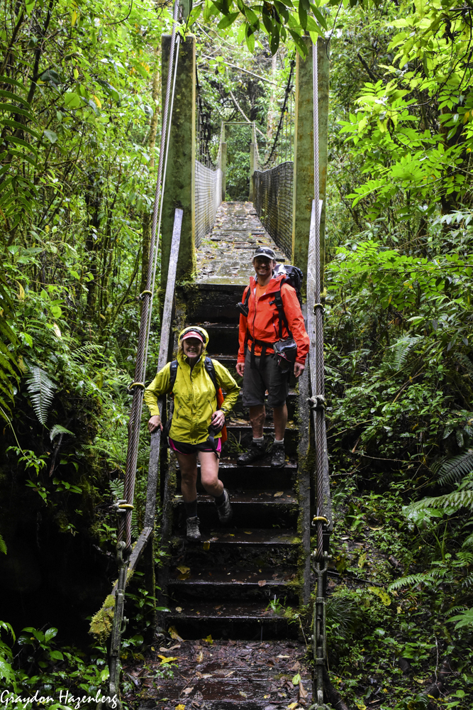
Our two full days in Boquete, a town with a very cool hippy traveller vibe, were devoted to hiking.  The first morning we caught a taxi up to the end of the road above town to access the Sendero de  los Quetzales (the Quetzal Trail), a famous hike.  Many gringo tourists get talked into taking a guide (at considerable expense) to walk the trail, but we figured that it was pretty well marked and couldn't be that fearsome, so we went by ourselves.  It was a lovely day of walking, leaving behind the coffee plantations cleared from the native bush and entering some fairly undisturbed cloudforest.  We never spotted any of the resplendant quetzals for which the trail is named, but we did hear several of them calling, leading to long minutes squinting through the dark canopy for birds that had no interest in being seen.  The walk was pleasant but by no means challenging, and we returned to town happy with a relaxed day in nature.


Saakje and Henkka were keen to climb Volcan Baru, the highest peak in Panama, the next day, which meant leaving at midnight to catch clear skies at the summit at sunrise.  Terri and I were less interested, so we waved them goodbye and went to bed.  Instead we slept late and welcomed back the conquering summitteers that morning before heading out for a much easier walk, up to the Lost Waterfalls.  It was a fun but very muddy hike leading to a series of spectacular cascades fountaining down out of the mountains.  As we got back to town, we arranged to meet up with Saakje and Henkka at the Boquete Brewing Company, a fabulous  brewpub, for a farewell to the town.

One of the Lost Waterfalls

A Lost Waterfall
Although we had enjoyed our time in Boquete, Saakje and Henkka were keen both to see more of the Pacific coast and to try their hands again at surfing, so we decided to make our next stop somewhere on the Pacific coast on the way back to Panama City.  It was approaching New Year, and so we were competing with all of middle-class Panama for accommodation.  We were almost despairing of finding a place when we finally located a hotel with rooms available in the little town of Moriato.  It was a long series of buses (to David, then along the Panamerican to Santiago, and finally a crowded local line to Moriato), but we got there in the end and decided that we had made the right decision.  Our little hotel (curiously empty given the season) was just inland of a beautiful natural beach with waves breaking all along it, and with an estuary full of seabirds at the far end.

Another Lost Waterfall


Playa Reina


Brown pelican

Our three days on the beach passed in a bit of a blur.  We rented much longer boards than we had had on Bastimentos with much better flotation, and it made all the difference.  We were much more able to paddle fast enough to catch waves and started to stand up on them.  Saakje proved herself to be the fastest learner, while Henkka wasn't far behind.  I was the least gifted of the three of us; Terri elected to watch from the beach.  We surfed as much as waves and tide allowed, and the rest of the time we wandered the beach and the estuary in search of bird life, or walked into the town centre of Moriato in search of pizza and fruit juice.  It was a relaxing time, punctuated by chats with the other guest in the hotel (an American guy on a motorcyle trip around Panama), card games in the evening and yoga sessions to loosen up muscles that were tight after the unusual activity of paddling a surfboard.

Cool toad from our hotel restaurant

Ibis and cormorants

Panama City, Pipeline Road and the Canal


Crimson-backed tanager

Crimson-crowned woodpecker
Our days in Panama were rapidly running out, and so regretfully we bade farewell to the coast and caught a bus into the city.  Terri and I booked a room in the same place as before in Casco Viejo while Saakje and Henkka stayed in a sister property a couple of blocks away.  Terri and I raced off to the Parque Metropolitano, the magnificent patch of rainforest in the middle of the city, and had a fun speed hike around the park before it closed, spotting lots of turtles and various birds (including a dramatically coloured crimson-crowned woodpecker, Campephilus melanoleucos), but none of the giant anteaters that Henkka had seen a couple of weeks before on his way through the city. An agouti (a large and rather endearing rodent) had to serve as a consolation prize.  We dined together with Henkka and Saakje in Finca del Mar, then arranged to rendezvous early the next morning for a day of birdwatching in the Canal Zone.

Black-striped woodcreeper (by Henkka)

Chestnut-mandibled toucan (by Henkka)
An Uber drove us inland from the capital along the main road through the Canal Zone, and we were soon deposited just past the town of Gamboa, at the start of a dirt road with the rather prosaic name of Pipeline Road.  This is known as the best birdwatching spot in Panama and one of the best in the world, so it seemed like a good place for Terri and I to spend our last full day in the country.  As soon as we stepped out of the car, we were already surrounded by wading birds in a marsh beside the road.  After spending a while photographing them and trying to identify them (our favourite was the rufescent tiger heron, Tigrisoma lineatum), we ventured into the embrace of the forest.  There were birds galore to be seen, including Central American specialties like antbirds, motmots, antwrens and caciques.  Since this is such a famous birding spot, there were a number of parties of serious twitchers, some with local guides, and we shamelessly parasited off their knowledge and their tips.  

Hideous facial deformity on baby howler monkey

Perhaps the most memorable encounter of the day was also the loudest.  We passed underneath a party of black howler monkeys and while we were watching them and trying to get a decent photograph, they began their howling.  For ten minutes, the forest was filled with their deafening calls until they ran out of interest and returned to eating leaves.  We managed to get a few monkeys to pose in small patches of sunshine, including a mother with a youngster on her back.  It wasn't until a couple of weeks later, looking at the photo more closely, that Saakje realized that the baby had hideous facial deformities, probably due to papillomaviruses.  I hadn't noticed them at the time through my binoculars or my telephoto lens, but once I'd seen them, I couldn't forget their nightmarish appearance.
Female slaty-backed trogon (by Henkka)

Juvenile rufescent tiger-heron

Terri looking pleased with herself at Miraflores Locks

In addition to birds, there were leafcutter ants wearing paths through the undergrowth, spectacular butterflies and big dragonflies to admire, and sooner than we would have liked it was 1:30 pm and we were hungry, thirsty and tired.  We trudged out back to town and raided a convenience store for overpriced snacks and cold drinks which we ate in a nearby city park that was itself full of bird species.  Henkka and Saakje were staying in Panama after we left, so they had booked a room in Gamboa so that they could return to Pipeline Road the next day.  (They had spectacular birding luck the next day, leaving us quite envious and keen to return one day.)  Terri and I headed back to Panama City, but with a stopoff at the Miraflores Locks of the Panama Canal.  Terri was keener than me to see them, but I ended up glad that we had stopped in and paid the 15 US dollar admission price.  We spent a good couple of hours sitting in the bleachers watching huge freighters make their way through the locks (and even bigger super-Panamax container ships passing through the expanded second set of parallel locks), and wandering contentedly through the excellent museum.  Terri's father had been fascinated by the Panama Canal and had taken a round-the-world cruise largely to experience the Canal, and he had passed this fascination onto his daughter.  We both really enjoyed the experience and were wowed by the engineering feat of building the Canal.

Sloth crossing Pipeline Road (by Henkka)

And then it was all over.  We returned to the city, had a delicious final meal at a Chinese restaurant, and the next morning caught a flight to Miami and on to Doha, where we splurged on a hotel room and found time to explore the Museum of Islamic Art just before closing time, and had a memorable Indian meal.  Six hours of sleep, and we were back at the airport, checking in for our Tbilisi flight, our Christmas holidays enjoyably spent. 

Little did we imagine that within two months, the world of international travel would be completely changed by covid-19, and that this would be our last trip in the world of the BC era (Before Coronavirus).  We have yet to do a real trip in the AD era (After the Disease), but Panama was a good spot to do our last trip for a while.  If I were to go back, I think I would want to have a vehicle (or a bicycle) to explore a bit further off the beaten track, and I would spend more time in the rainforests and cloudforests looking for birds and other wild creatures, as that's what I found most spectacular about the country.
 
Museum of Islamic Art, Doha