Showing posts with label hiking. Show all posts

Saturday, April 14, 2018

New Zealand, Feb. 2018: The Northland Loop


Lipah Beach, Bali, April 14th

I have just gotten back from 7 weeks on the North Island of New Zealand and it seems as good an excuse as any to finally restart my travel blog, which has been inactive for most of the past year.  There will be more blog posts to come, on the New Zealand trip, other travels over the past year, and upcoming plans.  I haven’t been completely inactive on the writing front; I’ve just been diverting my scribbling energies into writing a book based on my Silk Road cycle ride, and haven’t been doing enough new travels to divert me from that task.

I've created a Google Map of this section of the trip that you might want to open in another browser tab by clicking here.

One of the Muriwai gannets in flight
I set off from Bali on February 13th to join Terri, who had set off a week earlier than me to catch up with her family.  It had been 26 years since my only previous trip to the country, and that had concentrated mainly on the South Island.  This time Terri and I decided to restrict ourselves to the North Island, both to see the attractions of this part of the country in greater detail, and to visit members of Terri’s large family and her sprawling network of friends.  We rented a small car, filled it with camping gear and set off from Auckland airport in high spirits.

We started off with a night in Auckland, visiting Terri’s cousin Jocelyn and her husband Bob.  We had a wonderful dinner and a quick spin around the bays around their house after I spent a few hours catching up on the sleep I hadn’t had on the flight over.  

A view of the wild west coast beaches of Muriwai
The next day we headed through Auckland and out west, across the Waitakere mountains to the wild black sand beaches of the West Coast.  We started with a visit to the clifftop colony of Australasian gannets at the small town of Muriwai.  I loved the energy of the pounding surf against the steep rock ramparts and the swirling aerobatics of the birds, which reminded me of birdwatching in the Falkland Islands back in 2015.  Then we drove north to the small town of Piha and spent a few hours hiking north on a good trail through the coastal bush to deserted beaches before heading back to the car.  It was my first time to really pay attention to New Zealand’s birdlife, and as I leafed through the pages of our newly-purchased bird guide, I realized that in comparison to most other countries, New Zealand has a very restricted number of bird species, and the most commonly seen are species from Europe or Australia such as sparrows, mynas, starlings and blackbirds that were deliberately introduced to the country by early European settlers.  These introduced bird species, and even more the land mammals such as stoats, rats, mice, hedgehogs, possums, cats, goats and deer that the settlers released into the wild, have had a catastrophic effect on the NZ ecosystem, driving many endemic bird species to the brink of extinction or over it. 
The view back down to Piha
The deserted beaches south of Karekare

We spent the night camped in a Department of Conservation (DoC) campsite full of large kereru pigeons, an endemic species.  We awoke to find the tent fly dripping with condensation from the heavy dew that we experienced every time we camped.  We spent the day on an even prettier hike, this time south of the village of Karekare, under steep volcanic cliffs and through extensive sand dunes, then through a fern-filled marshland on a new boardwalk and up onto a forested ridge providing spectacular views of the wild beaches.  The dunes were full of small ponds full of waterfowl, and the path was in wonderful condition, a contrast to Terri’s memories of muddy DoC trails from her youth.  We came back to the car smiling from 4 hours enjoyably spent, then drove north towards the dairy farm that Terri’s daughter Selena and her husband Michael run near the town of Wellsford.  We ended up camping in a free campsite nearby on the edge of a big inlet.

Terri and 4 of her 5 GKs
We spent the next day with Selena, Michael and their five young children, getting a tour of the farm and feasting on waffles cooked up by the oldest children.  In the late afternoon we said our goodbyes and drove off to our first AirBnB of the trip, a room in a house near the Dome Mountains owned by a Russian couple.  The setting was very peaceful and rural and we had a fun walk around the surrounding countryside before cooking up dinner.

The next day we had a double-header of pretty hikes.  We started out with a climb up to the summit of the Dome, a couple of hundred metres above the road, through a well-signposted forest that taught me the names of a number of the characteristic New Zealand native trees.  We saw our first tui of the trip jumping around in the forest canopy while emitting an impressive array of squawks, squeaks and parrot-like vocalizations.  We were to find that the unmistakeable voice of the tui is one of the most distinctive sounds of any NZ bushwalk.  From the top of the hike we had a clear view down over the main road and across the peaks of the Northland region, and were excited to realize that we were walking along a stretch of the Te Araraoa, the 3000-kilometre-long hiking trail that runs the entire length of New Zealand; we would encounter it several more times in the course of our travels.
Looking down onto the beach at Mangawhai Heads
Terri on the Mangawhai Heads trail

We had lunch, then drove north and east for our second walk of the day, the spectacular cliff-top trail at Mangawhai Heads.  It was one of the scenic highlights of the entire trip, a new walkway that clings atop precipitous cliffs over the east coast beach at Mangawhai before dropping down onto the beach for a scramble across the rocks onto the main beach of Mangawhai.  It may have been the single most impressive coastal panorama of our 7 weeks, and we both fell in love with the laid-back feel of the small town of Mangawhai.  We came back to the car and raced off north, past other pretty beach towns, to the city of Whangarei where we stayed with my old friend Eileen and her family on a wonderful sprawling property just outside town, had a big barbecue and soaked in their Jacuzzi staring up at the southern stars late into the night.
Reunited half a lifetime later with Eileen
Looking down from Bream Heads

We went off the next day for another hike, this time at Bream Heads, an hour east of the city.  It was a much higher, steeper and muddier track than at Mangawhai, but sweeping views provided ample reward for the additional effort required.  We retreated to Whangarei and another night at Eileen’s.  She and I hadn’t seen each other for 22 years, so there was a lot of catching up to do.
Terri and her niece Amy
Team Hundertwasser in Whangarei
The funky public toilets of Kawakawa
From there we were headed north, as far north as you can get in New Zealand without needing a boat, to Cape Reinga.  On the way out of town we stopped in to see the new downtown of Whangarei, neatly gentrified with cafes and a big sailing harbour, where a proposed museum for the artist and architect Friedensreich Hundertwasser is about to be built, after a quarter century of stops, starts and arguments.  Eileen has been involved over the last few years in these efforts.  We also caught up with Terri’s niece Amy, recently moved to Whangarei.  The drive north was a long one, through intermittent heavy rain from a passing cyclone, Gita, which meant that the Bay of Islands, a famous scenic highlight, ended up being scratched from our itinerary.  One place that we did visit were the quirky Hundertwasser Public Toilets in Kawakawa, surely the most beautiful public toilets in the world.  We ended up stopping for the night at another AirBnB run by an energetic Filipina woman on a dairy farm an hour’s drive south of the Cape, where we repacked for a two-day hike, leaving behind some valuables that Terri was concerned about having in our car overnight.

Terri with the Cape Reinga lighthouse behind
Me looking down on Te Warahi Beach
Our overnight trek south from Cape Reinga ended up being one of our favourite parts of the entire New Zealand trip.  We drove north, leaving our car at a little campground and catching a very expensive lift to the end of the road.  The cyclone had passed and the weather was sunny and clear.  The views were incredible, over an ocean boiling with massive swells that were crashing into high cliffs.  We shouldered our packs and set off from the Cape Reinga lighthouse, headed south along the first section of the Te Araroa trail.  The trail alternated between clifftop and beach sections, and the first beach section, dropping onto Te Warahi Beach, featured a rather dicey descent where a rapidly rising tide almost swept Terri away.  Once we were safely onto the sand, the walk along the wild, windswept dunes was exhilarating, and we were lucky to spot a blue penguin, the smallest penguin species in the world, standing on the beach, looking so bedraggled and bemused that we wondered if he was lost or disoriented.  A couple more beaches along, we found our DoC campground, the Twilight campsite, situated atop another bluff with breathtaking views over the pounding ocean.  It has recently been upgraded, with new toilets, a cooking shelter and a solar-powered water pump, and we had the place entirely to ourselves.  Grilling steaks and sipping a lovely NZ merlot, we spent a memorable evening.  Terri channeled her inner muse to come up with a short poem about the penguin:


Poor little pengy washed ashore

A more forlorn thing I never saw
Battered by Gita's cyclone roar
Stranded alone forever more.


Looking back north to Cape Maria van Dieman
Sunset over Twilight Beach
A New Zealand pipit seen near Twilight Beach
Our first view of Ninety Mile Beach

The next day we hiked further south, over more headlands and then down onto Ninety Mile Beach (it should really be called 85 Kilometre Beach; there’s a bit of hyperbole in the name), a huge length of undeveloped sand that ran south to the horizon.  We marched along it for a couple of hours, past hundreds of gulls and oystercatchers, before turning inland along the Te Paki stream.  We had to walk up the riverbed, often through the shallow stream, flanked by huge sand dunes.  Eventually we came to a roadhead where we stuck out our thumbs and got a lift back to our car with a young South Korean woman who was on a working holiday visa, a very popular way to see New Zealand.  We packed up the car and drove south, stopping to explore the Karikari Peninsula which Terri had heard good things about.  We eventually camped in another DoC campsite on the peninsula, an idyllic spot next to yet another beautiful beach.
Pied stilts on Ninety Mile Beach
To you it's a river, to the DoC it's a hiking trail.  Te Paki Stream
The dunes across the inlet from Opononi

From there we continued south, past the Bay of Islands, where I got third time lucky on the weather.  Despite its fame as a beauty spot, neither Terri nor I were very impressed with the place, as it’s awash in overseas tourists and very overdeveloped compared to the beautiful places we had seen further north.  Having ticked that box, we drove south along the west coast, past Maori villages, wilderness, the spectacular beach town of Opononi and eventually the kauri forests.  We stopped at Tane Mahuta, the largest surviving kauri tree, for photos.  Kauri are an iconic species of the New Zealand native bush, but between rampant logging in the 1800s and 1900s and an outbreak of a fungal disease, kauri dieback, the future of these forest giants looks a bit grim.  We camped for the night in Trounson Kauri Forest, an example of a “mainland island” pest-free wildlife sanctuary.  We spotted a rare native bird species (the stitchbird) and heard brown kiwis calling at night, but we had no luck spotting them on a nocturnal ramble through the woods. 
Mighty Tane Mahuta
Some of the big kauris in Trounson

Just before we camped, with the last scrap of phone signal (always an issue in rural New Zealand), I sent off an e-mail to Quality Schools International, a chain of international schools, who had offered me a teaching job for next academic year in Tbilisi, Georgia.  I enjoyed each of the three trips I have undertaken to Georgia over the years, in 2009, 2011 and 2015, and I decided to accept their offer.  I am looking forward to exploring the Caucasus mountains in greater detail, as well as perfecting my Russian language skills and making a start on Georgian.

Patterns in tree bark, Trounson
We awoke on February 24th to a loud chorus of birdsong emanating from the forest, always a good indication that the efforts to trap and poison the plagues of rats, possums and stoats have yielded good results at Trounson.  We had another walk through the forest in daylight:  it was an enchanting, mystical place dripping with moisture, ferns, moss, fungi and lianas.  We heard kiwis again, and spotted a couple of baby birds hidden inside a decaying tree trunk.  The rest of the day was devoted to driving south through dairy farming country, via a quick social visit with Selena, Michael and their family in Warkworth. 

The beach at Tawharanui
In search of a place to camp for the night, we blundered into another great conservation spot on the Tawharanui Peninsula.  The campground was full, but we took a couple of hours to wander through the replanted native bush in search of rare birds, and were rewarded with encounters with both the pateke duck (the brown teal) and the North Island robin.  The entire peninsula has been fenced off (with the fence extending deep underground) and the introduced pest species have been removed.  This provides a model for the long-term goal of eliminating these species entirely from the entire country by 2050, an objective recently announced by the government.  We took our leave regretfully and ended up camped cheek by jowl with hundreds of other campers in a grim, expensive holiday park in the village of Sandspit.
The kotare, or sacred kingfisher, seen at Tawharanui
The North Island robin, Tawharanui
Sandspit rock formations

Sandspit redeemed itself partially the next morning when we wandered along its beach and found beautiful sandstone formations.  We didn’t linger long, though, as we had an appointment to keep with Terri’s long-time friends Gavin and Michelle.  They live in Algies Bay, just south of Sandspit, and are keen outdoors folks.  One of their favourite pastimes is sea kayaking, and they happened to have a spare tandem kayak for Terri and me.  We loaded up the kayaks and set off after lunch for a brisk 2-hour paddle out to Motuora Island, another predator-free offshore refuge.  It was perfect weather with very little breeze or swell, and we had a wonderful crossing, even spotting 4 more blue penguins swimming in the bay.  We could see all to way to the North Shore of Auckland in one direction and out to Great Barrier Island in the other, a huge marine playground.

Loading up the kayaks in Algies Bay
When we got to the island, we were amazed to find that we were going to have it entirely to ourselves overnight, as the few daytrippers loaded up their boats and headed off in the late afternoon.  We went for an exploratory walk, then settled in for a delicious meal of grilled steaks and couscous.  Once the sun had set, we headed out again for a night walk.  As had been the case in Trounson, we could hear kiwis calling in the darkness, but both Gavin and Michelle said that they had never been lucky enough to see one in the wild.  Fortune was smiling on us, however.  We spotted a couple of moreporks, a delightfully named native owl that are more frequently heard than seen.  We turned back towards the campsite, having given up on kiwis, when suddenly there was a crashing in the bushes and a brown kiwi came tearing out onto the path.  He took one look at us and our lights, turned tail and was safely back in the undergrowth within a few seconds, but it was long enough to get a good look at him.  We were elated as we trooped back to our tents.

Fearless adventurers about to embark
The paddle back to the mainland the next day was a bit harder, as a brisk breeze had sprung up overnight, kicking up a noticeable swell.  We took a different route back, ending up in an estuary in which a tall ship, the Spirit of New Zealand (used for school groups) was moored.  We paddled right underneath her, feeling dwarfed in our kayaks.  The trip finished with a shuttle of kayaks back to Algies Bay and a great meal with Gavin, Michelle and their newly-arrived niece and nephew-in-law from Australia.  I really enjoyed sea kayaking, as it’s something I’ve never really done, at least not overnight.  It’s a different way of seeing the world, and allows access to very different places than you can get to by hiking or cycling while still getting lots of exercise.

Overall, our 13 days in the area north of Auckland were a major highlight of our New Zealand experience, jam-packed with activities, spectacular scenery and memorable wildlife encounters.  It was almost sad to head south on February 27th, passing through Auckland on our way down the east coast of the North Island, which will be the subject of the next blog post.  I hope you enjoyed reading about our trip, dear readers.  You might also want to cast a quick eye over a Google Map of our trip, found here.
Terri and I in paddling action

Thursday, May 11, 2017

Retrospective (July, 2012): Footloose in the Kyrgyz Mountains

Thunder Bay, May 11th

After my disappointing result on Peak Lenin back in July, 2012, I arrived back in Bishkek on July 18th to meet up with my partner on the upcoming Muztagh Ata climb, Eric.  He had arrived from Europe the day before and we met at the Asia Mountains Guesthouse, where we were installed in a comfortable room.  It was good to see him, and to look forward to new mountains and (we hoped) more success than I had had on Peak Lenin.

Kyrgyz life is all about horses and mountains 
July 18th and 19th passed in delightful sloth in Bishkek, buying supplies, eating and drinking well and planning our next move. We were leaving with the rest of our Muztagh Ata expedition on July 30th, which left us with 10 days or so of freedom to do some exploring.  Eric had just arrived from sea level, so we wanted to get some altitude into his blood, and some hiking into his legs.  We tossed around various ideas, including the Inylchek Glacier, one of the world's largest glaciers outside the polar regions, but logistics and timing were tough for the Inylchek, so we decided to go hiking on our own in the Terskey Ala-Tau mountains south of Lake Issyk Kul.  I had cycled along the north shore of the lake back in 2004, but hadn't gone to the south shore or stopped to do any hiking, and our guidebook made it sound like a great place to explore.  We stored our skis and heavy mountaineering gear in the storage room at Asia Mountains and set our alarm clocks for early in the morning of July 20th.

It was just as well that we got up at 6 am, as it took a while to get to the mashrutka stand and get going.  We inadventently took the long way to our destination, the town of Kyzyl Suu; we went first around the north side of the lake to the large regional centre of Karakol (the old Przhevalsk) and then took another marshrutka to Kyzyl Suu, rather than taking a direct marshrutka to Kyzyl Suu along the south shore of the lake.  This was, perhaps, a foreshadowing of route-finding to come!  It was a long ride in the minibus, although the scenery was pretty in places.  We were retracing my 2004 cycling route in reverse, and I remembered highlights like the ruins of the old Blue Turk capital of Balasagun (now called the Burana Tower near the dismal town of Tokmok).  The views across the lake were stunning, with a backdrop of snow-capped mountains (our ultimate destination) rising over the deep blue water.  We drove past the town of Cholpon Ata, where I had explored the ancient petroglyphs on the outskirts of town back in 2004, and stayed with a friendly Kyrgyz cyclist and his wife.

With a stop for food at a little roadside cafe at the northwest corner of Lake Issyk Kul, it took six and a half hours to get to Karakol. Once there we visited the rather unhelpful tourist office to try to figure out how to get to our hiking trailhead, and stopped to buy necessary supplies like bread, beer and gasoline for my MSR stove.  Eventually we caught another marshrutka for another hour to Kyzyl Suu, and then found a taxi driver to take us to Dzhyluu Suu, where we would start hiking.  We negotiated a price, threw our bags in the trunk of the Lada and set off.  As we drove, I thought "this isn't the road shown on the map!" and talked with the driver, but he insisted that we were headed to Dzhyluu Suu.  I was dubious, and when we got out of the car after a long drive, beside the entrance to a Soviet-era hotspring complex, I questioned some locals as to whether this was Dzhyluu Suu.  Only when we were reassured that it was did we get our packs out and set off up the valley.  It was already 5:30 pm and we only walked 15 minutes up a narrow valley beside a rushing river to the first decent camping spot we could find.  We erected my tent and cooked up some eggs, bread and sausage for dinner and then lazed beside a fire that was tough to light, as dry wood was in short supply.  It felt good to be out on our own, free to walk wherever we wanted, out in beautiful mountains and soul-restoring conifer forests.  

Camping in another idyllic meadow
We slept well, lulled to sleep by the burbling water of the river.  By 8:00 we were up, gobbling down some muesli, yoghurt, tea and delicious fresh peaches.  A group of local Kyrgyz herders wandered by to say hello; although it was only 9:30 am, they were wobbly with vodka, and it was a bizarre, disjointed conversation.  Like so many post-Soviet states, serious drunkenness is a problem in Kyrgyzstan, despite most of the population being nominally Muslim.  By 10:00 we had packed up and were hiking upstream, headed towards a pass marked on our map.  We followed the path as it climbed away from the river up some fairly steep slopes and then petered out in a meadow full of beautiful wildflowers.  We were puzzled; our map showed this as a major hiking route, used also by local herders, and yet there were only vague suggestions of tracks and some trampled grass that looked as though it had been done by grazing herds.  We kept pushing onwards as the grass and bushes got deeper and denser, and within a couple of hours we were utterly flummoxed.  Where the hell was the path?  The slope of the meadows kept getting steeper and steeper, and the footing grew ever more precarious.  We kept hoping that at any moment we might stumble upon the proper trail that we assumed we had lost.

Lovely scenery; pity it was the wrong valley!

Eric in the lovely but trackless Suruu Valley
As we continued to flounder, Eric got more and more annoyed, and his mood was not improved when he slipped on wet grass and twisted his ankle pretty severely.  Moving at a hobbling pace, we eventually decided that we needed local knowledge, so we made our way downhill and across the river on a small footbridge, then up the other side of the valley to where we had seen several women walking around a couple of yurts in the middle of their jailoo (summer high-altitude pasture).  Almost everyone in Kyrgyzstan, and particularly older people, speak Russian, and my Russian is good enough to get by, but I didn't understand what our interlocutor, a middle-aged Kyrgyz matron, was saying.  It didn't seem to make any sense.  We showed our map and asked which of the two possible notches on the skyline was the pass we were looking for.  She frowned at the name of the pass (the Taleti), and said that the valley we were in led to a pass that was really fit only for mountaineers with ropes, and that she had never heard of the pass we named. We kept asking, and after much head-scratching and miscommunication, suddenly the light went on in her eyes.  She asked what village we thought we would reach across the Taleti Pass, and then cackled with merriment.  WE WERE IN THE WRONG VALLEY!  My initial misgivings about the taxi driver's direction had been right.  But how had this happened?  Wasn't this Dzhyluu Suu?  The woman looked at me pityingly.  "Don't you know what Dzhyluu Suu means in Kyrgyz?  Hot Springs.  There are hot springs in almost every valley; there are at least three near Kyzyl Suu,"  The taxi driver had taken us to a different Hot Springs than the one we wanted, and we had been floundering around up a dead end valley, the Suruu, that ended in cliffs.  We hadn't found a path because there wasn't one; the local herders drove their animals up to graze where we had been flailing, and we had been following animal tracks for hours.  "Why didn't you tell us we were heading the wrong way?" I asked, rather lamely; she had been watching us for quite some time, and could easily have signalled across to us.  "I thought you were looking for mushrooms," she replied.  "The only reason anyone other than us ever goes up there is to look for mushrooms."  

Cute Kyrgyz girl on cheese-making duties in the mountains
There was nothing for us to do but to cut our losses and retreat the way we had come, muttering imprecations about our own stupidity and about the taxi driver.  We were two valleys west of where we should have been (the Jety Oguz valley), and the Suruu valley (the one we were in) really didn't lead anywhere.  Eric's ankle was swelling and painful, and we needed to get to a real trail that was on our maps.  It was hardly an auspicious start to our hiking adventure, but at least we knew what had gone wrong.  We bought some fresh bread and some fresh ayran (a salted yoghurt drink) and headed slowly back down the valley until we found a promising meadow to camp in.  We cooked up a nice dinner and sat around a campfire, shaking our heads at how we had managed to delude ourselves for so many hours that our reality corresponded to where we thought we were on our map.  It was funny now, but it hadn't been so amusing when we were completely lost and mystified.


Filling the valley with our campfire smoke
We slept deeply again that night, and woke up to beautiful weather.  We breakfasted on muesli and ayran, and had a visit from the lady from the jailoo.  Having talked that evening with her husband about the crazy foreigners, she was concerned that we would try to climb the treacherous pass at the end of the valley, and was relieved when we assured her that we were headed downhill instead.  She brought us more ayran for free (Kyrgyz hospitality in the mountains is legendary) and we put it into the side pocket of my backpack.  We traipsed down the valley for an hour and a half, including a rather cold river crossing, to the hot springs where we had started our little misadventure.  A local taxi driver agreed to drive us back to Kyzyl Suu for 600 som (a bit over US$ 10), and off we went.  We stopped in town just long enough for Eric to buy 2 kg of amazing raspberries, then caught another 600 som taxi to the Jety Oguz sanatorium, where we thought we had been two days earlier. This was a much bigger, grander hot spring development than where we had just been, and we walked along the road upstream with dozens of Ladas passing us in both directions, stuffed full of families and groups of friends.  Eventually we got tired of the traffic and flagged down a lift with a group of drunk Kyrgyz men (the driver was only slightly less sloshed than the others) in a minivan.  We got dropped off in a huge meadow full of yurts and tents that wasn't even slightly appealing as a place to camp, then hiked upstream along the river to the final bridge before our valley, the Taleti, branched off.  The scenery was grand and sweeping and beautiful all along the valley, much more so than the previous day, and we actually knew where we were!  We passed a series of meadows and pine glades before settling on a quiet, secluded spot in a long, narrow riverside meadow.  We set up camp and relaxed around a roaring but smoky fire.

Eric climbing painfully up the Teleti Pass
The next day, July 23rd, we finally got our planned hike underway.  We slept as soundly as ever and woke up at 7:40 to cloudy skies that presaged a change in the weather.  We finished off our our ayran supply on our muesli, then packed up our tent and headed off.  We passed the tent of Petr and Adam, two Czech backpackers whom we had met briefly the day before.  They were headed the same way we were and we checked in with them to see if we were going the right way; we had lost confidence in our route-finding ability during our debacle of the previous two days.  Having confirmed our route, we hiked uphill for an hour until the Teleti valley branched off.  We turned into our valley and continued uphill, stopping in at a yurt for some fresh cream and cheesy nibblies before continuing uphill.  At 2700 metres' altitude we entered a lovely open, flattish landscape.   Our path led through a marshy area, and despite our best efforts to stay dry, we both broke through the mat of vegetation on the surface to mid-thigh (Eric once, me twice).  We were very soggy when we met Petr and Adam again, leapfrogging each other at snack stops.  We had another river crossing (more cold water soaking the boots, as it was too rocky for either of us to want to take off our boots) and then climbed steeply and sharply uphill towards the crest of the Teleti Pass.

Eric started to lag behind badly, suffering both from altitude (we were up at 3350 metres) and his increasingly painful sprained ankle. I had lots of time to wait for him and to look around at our surroundings.  They were magnificent, with grey stone spires rising into view as we escaped the steep valley walls that had imprisoned our lines of sight.  Big patches of snow still lingered here deep into July, but below the rocky peaks there was a luminescent green of fresh grass and fir trees, speckled by millions of blooming wildflowers.  It was something out of an 19th century romantic painting, and I realized that this, rather than the harsh high altitude deserts of Peak Lenin, was what I liked most in the mountains.  Rather than being just a warm-up for Muztagh Ata, maybe this was the main course?

Campsite with a view below the Teleti Pass
The skies continued to darken, and I decided to move ahead to arrange some shelter in case it started to rain.  I found a flat patch to pitch the tent (no easy task in this very vertical world) and had everything set up when Eric finally wobbled into camp, clearly suffering from the pain in his ankle. We had a huge feast of pasta, tuna and tomato sauce and then lounged around on the grass watching the afternoon light fade on the peaks.


The wildflowers were everywhere, and burrows and droppings indicated that there must be animals as well, but they stayed out of sight.  I imagined that there were probably marmots and foxes, and perhaps wolves too, although I hoped that the wolves would keep their distance from us.  As we lay there in the grass, Eric smoking his daily hand-rolled after-dinner cigarette, it all seemed impossibly idyllic.

Eric reclining on the grass, a touch of Italian elegance around his neck

The next morning, July 24th, we were up at 7:00 am, our earliest morning yet on the trail.  For breakfast we finished the last of the raspberries from Kyzyl Suu (just before they fermented) atop our muesli and yoghurt.  Petr and Adam stopped by, having camped below us the night before but being earlier risers than us, and continued on their way towards to the summit of the pass, some 400 metres above us at 3760 m.  We packed up and got ready to go, but when Eric went to the nearby stream to get water, his ankle failed him and he fell in, soaking himself.  He was not amused, and it was a sign of things to come, as his ankle was in bad shape.  We left at the leisurely hour of 9:20 and took a little over 2 hours of easy climbing to reach the top of the pass, passing through a riot of wildflowers and butterflies before entering a world of rocky scree just below the pass.

Descending from the Teleti Pass
As it turned out, the climb was the easy part.  The descent from the pass down into the Karakol Valley was long, steep in places, treacherous in many spots and absolute hell for a man with a bum ankle.  In addition to the ankle itself, Eric's new, very stiff mountain boots were giving him horrible blisters, and he was hobbling downhill.  The last 400 vertical metres into the main valley were nearly vertical, and our well-defined path disappeared into a tangle of indistinct indentations in the grass.  Footing was tough, as water was seeping out of the ground making everything slick, and we both went down heavily a few times, luckily without further injury to Eric.  Eric was convinced that we must be going the wrong way, down the wrong side of the river, but there were no signs either way, and once we were committed, the river was almost impossible to cross.  We soldiered on, and eventually came out on flattish ground down in the Karakol Valley just as it started to rain.  We were a dispirited pair as we trudged to the nearest possible camping spot and put up our tent.  Supper was an affair of instant noodles, and Eric was in serious doubt about whether he would even be able to walk the next day.  Given that Muztagh Ata was our main objective, it seemed best for us to curtail our walk and head as soon as possible to a roadhead to catch vehicular transport somewhere where he could rest his leg.

Our kind-hearted saviour in the Suruu Valley
Re-reading my diary now, I realize that I'd forgotten what I was reading those long evenings in the tent on Peak Lenin, and now in the Terkey Ala-Tau.  My Kindle was stocked with lengthy, worthy literature that I might not have the patience to wade through in other settings.  That evening I finished off Marcus Aurelius' Meditations (which I had been inspired to read by William Irvine's recent book A Guide To The Good Life) and settled into Michel de Montaigne's Essays (which in turn I had been inspired to read by How to Live, by Sarah Bakewell).  I had been hard at work (and it was hard work!) on Remembrance of Things Past (or, as the new translation I was reading had it, In Search of Lost Time), Marcel Proust's epic doorstopper, the longest novel every published, but I was taking a well-earned break after spending all of my Ladakh evenings with him.  I had always tried to bring at least one tome with me on long summer expeditions; previous trips had found me with the complete works of Shakespeare, Thomas Musil's great pre-WWI Viennese novel The Man Without Qualities, and both War and Peace and Anna Karenina.  It was always good to feel that I had improved my cultural education when I came back from a long hike or bike trip.

July 25th found us slow to wake up, as there was no sunshine to wake us up, and we were both pretty tired after a long day the day before.  We cooked up some oatmeal, finished off our yoghurt supplies and then slowly wandered down to the tourist yurt camp at the mouth of our valley, where we bought some overpriced bread.  We continued downhill in the main valley for a couple of hours on a track that was deteriorating.  It was spitting rain, but we paused under a sheltering tree beside the track for a delicious salad and cheese lunch.  We then hobbled further down the valley to the beginning of the road, past yurts and small houses.  The scenery continued to be beautiful, despite the grey skies, and I wished that we could continue our footloose odyssey for a few more days, but Eric desperately needed to be off his leg as soon as possible.  At the roadhead we tore a taxi driver away from his vodka and cards and had him drive us to Karakol, where he found us a cheapish room (800 som, or US$ 16) in a dismal hotel/brothel.  It didn't matter to us; there was a roof over our heads, and good takeout shashlik to eat just down the street.  We had showers (which felt good after 5 days of hiking), called our respective partners (it was the first phone signal we had seen in days) and went to bed.

July 26th found the skies clearing and us keen to get somewhere on the shore of the lake.  We ended up bargaining a good price with the driver of a Mercedes to get dropped off in Cholpon Ata, and found ourselves on the main strip of the highway.  Issyk Kul is a very popular summer lakeside resort for Kyrgyz and (especially) Kazakhs, and it's a clone of many of the resort towns I had stayed in in Russia and Ukraine on the Black Sea coast the summer before.  We found a cheap room in a small anonymous hotel and settled in for two days of people watching, good food and relaxation.

The water was frigid, but it didn't deter hardy Kyrgyz holidaymakers.  Eric thought it reminded him of Italian beach resorts on the Adriatic in his youth, and there really was a feel of the 1950s or 1960s to it.  The town had once been a massive sanatorium, and the ruins of the old complex still dominate the foreshore, with small bits dolled up as smaller hotels or privatized sanatoria.  We visited a slightly weird museum, the Ruh Ordo, all grandiose national pride and slightly pompous modern architecture, dedicated to Kyrgyzstan's greatest modern writer, Chingiz Aitmatov, to get our cultural fix.  Mostly, though, we sat on the beach or walked, unencumbered by big backpacks, along the sand.  It was fun to spend a couple of days on the beach and a couple of nights reclining in chaikhanas, eating delicious lamb shashlik and sipping green tea and cold beer, but it was a poor substitute for hiking in the transcendent mountains of the Tien Shan.

I really enjoyed cycling through Kyrgyzstan back in 2004, and I really enjoyed our brief hiking journey in 2012.  If I were to recommend one area of the world for some really wonderful off-the-beaten-track adventures, either on foot or on bicycle, Kyrgyzstan would be near the top of the list.  I would love to go back again for more adventures, or even work in Bishkek and explore the country on weekends and holidays.  The fact that an almost unknown minor mountain range like the Terskey Ala Tau contains peaks higher than any in the Alps tells you how much exploring there is to be done in the mountains of this Central Asian Switzerland.

We walked past so many wonderful wildflowers
July 28th found us in a marshrutka, heading back to Bishkek.  Asia Mountains' main hotel was full, but they put us up in their overflow complex, Asia Mountains II.  The Olympics had started in London, and we spent a lot of time watching the early events.  As well, since most of the climbers I had met on Peak Lenin had been employing the services of Asia Mountains, I met a few climbers whom I had last seen moving up the mountain while I was retreating.  Tim, one of the northern English climbers I had met at Camp One, was back and had summitted, one of the very few successful summitteers during that period.  Alex Goldfarb was back as well, and had a harrowing tale to tell.  He and his guide Dasha had pushed towards the summit in horrible winds (go figure!) and had made it to within 100 vertical metres of the summit, but they had been moving slowly and when they finally made the decision to turn around, they ran out of daylight before finding their way back to Camp Three.  They had wandered around lost, with Alex convinced that they would freeze to death out in the open, for hours until Dasha finally found the tent around midnight.  They had made it down, but barely.  I was starting to feel a lot more confident that I had made the right decision in turning back.  Branko and his fellow Slovenians were back as well, having made it to the top of Razdelnaya Peak (the 6148 m bump on the ridge behind Camp Two) but no further.  It certainly seemed as though this summer was a particularly tough one for success on the 7000-metre peaks of Central Asia, the so-called Snow Leopard Peaks, and I had been unfortunate in terms of choosing 2012 as my mountaineering summer.

I also had a run-in with Turkish Airlines while I was in Bishkek.  I wanted to know how much it would cost to change my flight back to Geneva if our expedition were delayed in China (I had no margin of error, being scheduled to depart less than 24 hours after our scheduled return), but Turkish said that if I wanted to change anything, I would have to buy a new ticket.  I was surprised, and not a little annoyed, but there it was.

And then, suddenly, it was July 30th and Eric and I were loading our skis, our mountaineering gear and everything else into a hellaciously overloaded minivan for the 2-day drive to Kashgar.  Eric's ankle and feet had healed, and we were ready for the last leg of my 2012 summer adventure:  Muztagh Ata!

Tuesday, March 28, 2017

Country, Interrupted: South Africa (and 24 hours in Lesotho!)--January, 2017

Thunder Bay, March 26

I am sitting on the third floor of my father's house, looking out on a grey, drizzly day; the clouds are obscuring the usual view of the Sleeping Giant peninsula out across the waters of Lake Superior.  Not an inspiring day to go outside, so it's an ideal day to write and catch up on the next few weeks of Stanley's Travels, in South Africa back in January.

When we entered South Africa from Swaziland on the afternoon of Friday, December 30, we had a basic plan for our swing through the country.  Despite buying the car in South Africa and spending over a month there, we had barely scratched the surface of this huge, diverse country.  We had spent a frustrating week vehicle-hunting in Cape Town, a couple of weeks in Kruger, and another frustrating couple of weeks in and around Sabie as we waited for repairs to Stanley.  Later we spent some time in and around Upington, and then camped near Delmas at the Blinkgat workshop, but the entire southern three quarters of the country was an unknown quantity to us.  

Our idea for this leg was to make our way south along the Kwa-Zulu coast, stopping to see wildlife in Imfolozi, to hike in the Drakensberg and in Lesotho, and then to take our time along the Wild Coast and Garden Route, and then past Cape Agulhas to Cape Town.  We would then finally turn north along the coast towards the Fish River Canyon and finally get to Namibia in time to catch a flight back to Johannesburg to do a week's worth of tour guiding in Kruger in the middle of February.  It seemed like a good way to maximize our exposure to the various biomes and mammal and bird species of South Africa.

Rhinos, Bushbabies and the Green Hills of Africa


Umfolozi's green and pleasant hills
We had thought of heading up to the coast at Saint Lucia for some diving, bird-watching and whale-watching, but it was the height of the domestic tourist season and the heavy traffic on the road convinced us that the coast was going to be jam-packed.  Instead we headed towards one of the lesser-known jewels of the South African national parks, Imfolozi-Hluhluwe.  Far less well-known in the outside world than Kruger, this park saved the southern white rhino from extinction at the end of the 19th century.  In 1895 there were somewhere between 20 and 50 white rhinos in all of South Africa, after a frenzy of uncontrolled hunting had driven the species to the brink of extinction.  All the survivors were in what would soon become Imfolozi, and over the next sixty years, the now-protected population increased to nearly 1000 individuals, which were then sent out to other parks and reserves in Project Rhino, headed by golfer Gary Player's older brother Ian.  This reduced the risk of one outbreak of disease or predation wiping out the species entirely, and now the population of southern white rhino stands at about 20,000 throughout southern Africa.  The sad irony, though, is that having saved the species once, it is now threatened with extinction again, with over 1000 white rhinos a year being poached every year to feed the insatiable Chinese market.

Who you lookin' at?
For some reason there is no camping allowed in Imfolozi-Hluhluwe, so we chose to stay not far from the park in a wonderful little campground at Bushbaby Lodge.  Set in a small game ranch full of various grazing animals, it was a perfect place to unwind over the New Year period.  Our favourite feature of the place is that a few thick-tailed galagos (Otolemur crassicaudatus, as opposed to the "true" bushbaby, Galago moholi, which is much smaller; we saw both species in Kruger last May) live in the bush on the property and come out at 8 pm every night to be fed pieces of fruit by the owner of the lodge.  We saw them one night at the feeding, and then another night right above Stanley as they moved through the treetops after the feeding.  They are ridiculously cute, and for the first time we heard their calls, which do sound a lot like a human baby in a bad mood and which give them their "bushbaby" name.  We also noticed, as we had just come from Madagascar, that they are very similar to some of the smaller nocturnal lemurs we had seen, and their scientific name, Otolemur, gives a nod in that direction.  Looking it up, it seems that lemurs, galagos, pottos and the lorises of Asia are all in one suborder of primates, the strepsirrhini, that arose in the 10 million years or so after the end of the dinosaurs.  The similarity is definitely visually striking!

Mother and child white rhino looking a bit thin in Umfolozi
The last day of 2016 found us up a bit sluggishly, and after a prolonged breakfast we pulled down Stanley's roof and headed to Imfolozi-Hluhluwe.  We drove the longer way around to the Imfolozi sector of the park, and the combination of the longer drive and the late getaway meant that we were there in the cauldron heat of midday.  We flashed our Wild Cards and got in for free; the Wild Cards might be the best value for money of anything we bought in South Africa throughout the entire year. It was ridiculously hot, and most of the animals were sensibly hiding in the shade somewhere.  We did, however, see lots of white rhinos just as we entered the park; with 1600 in residence, it's hard for all of them to hide out of sight!  We didn't get quite as close as we had at Hlane two days before, but we still got great views.  The rhinos looked thin, with their ribs sticking out; perhaps the prolonged drought, which was just in the process of breaking, had affected them.  We saw several mothers with calves, good news for the survival of the species.

Classic savannah in Umfolozi
Rhino poaching is one of the issues that unites almost all South Africans, and you see a lot of posters, billboards, stickers and online ads imploring people to protect these highly endangered iconic beasts ("charismatic megafauna").  The problem is that the poaching that is threatening to drive these animals into extinction isn't local villagers trying to feed their families; it's a highly organized, highly militarized transnational mafia syndicate using ex-military men from South Africa, Zimbabwe and Mozambique.  If the market for rhino horn isn't effectively stamped out in China and Southeast Asia, I see little hope for the various rhino species, with extinction looming within a couple of decades.  One approach being tried in areas around Kruger and in KZN , as well in Namibia and Zimbabwe, is pre-emptively dehorning rhinos so that there's no horn for poachers to steal.  

We also had a few good close encounters with giraffes, a species that always makes me happy, as well as lots of baby impala, buffalo and wildebeest.  The landscape of Imfolozi was also a highlight; with the recent rain, the hills were verdantly green, and the sight of such green veldt after months of driving through drought-parched countryside was very pleasing to the eye.  We drove back to Bushbaby Lodge in a good mood, ready for the end of the year.


Mother zebra with very young baby 
Over the years the Hazenberg clan has evolved various traditions around New Year's Eve.  Gingerbread plays a key role, as we start eating the gingerbread structure that we have created over the previous week.  We started nibbling away at Gingerbread Stanley once we got back to camp, and shared a bit with the young kids of our camping neighbours Saul and Mandy.  Making lists of resolutions and of what were highlights and lowlights of the previous year are also essential, as are writing a few haiku about the past 365 days.  Terri good-naturedly played along with this, and as we waited for the stuffed chicken feast that she had prepared to bake in our little electric oven (since we hadn't been able to do this at Christmas in Swaziland, Terri was determined that we would have the benefit of a proper festive roast dinner), we both sat with paper and pen, surreptitiously counting syllables on our fingers and casting our minds back over the past 12 months of amazing travel.

A few of my 2016 haiku:

Wild animals pass
Living the African dream
In our metal box

Coppery sunsets
Over game-speckled grasslands
African journey

Trump gets elected
Cohen, Bowie, Ali die
2016 sucked!

I didn't say they had any literary merit!

We ate sumptuously well and then joined Saul and Mandy (a medical/physiotherapy couple from Durban) at their roaring campfire with glasses of whisky to toast out the old year.  By 10:30, sadly, we were so sleepy that we gave up on seeing midnight and headed to bed, sated and happy.  

New Year's Day was a lazy day spent in camp, having an outsized breakfast, catching up on laundry (the heat was resulting in a lot of sweaty clothes and bedding) and then walking around the property in search of birds.  It was a pleasant property to walk around, with lots of impala and birds, while across the fence we saw red duiker and strange all-black impala being bred on a game farm.  We lolled in the pool to beat the worst of the afternoon heat, and then went for a bicycle ride down the dirt road outside the lodge.  We didn't get very far, but it felt good to do some exercise after days of eating and driving.  We ate copious quantities of leftovers and packed up, ready for a timely departure the next morning.


Baby zebra
January 2nd saw us staggering out of bed at 5:20 for an early-morning game drive.  By 6 am we were packed up and underway, headed this time to the nearby gate of Hluhluwe.  It proved to be even hillier and prettier than the Imfolozi sector of the park, and once again we saw plenty of white rhinos on the way into the park.  There were many buffalo wallowing in the marshy areas near the rivers, along with plenty of zebras and a lone elephant.  We drove to a riverside picnic spot and there cooked up a lavish bacon-and-eggs feast.  We were slowly learning the South African style of game driving:  get up, grab a quick bite of rusks and coffee or tea, spend a couple of hours in the prime game-viewing opportunities just after dawn, then retire to a picnic spot for a big brunch.  We sat overlooking a river, but although we could hear hippos they weren't in our field of view, although we had some wooly-necked storks as compensation.  

After brunch we continued along the park, past more big buffalo herds, one with a few huge rhinos mixed in as they all wallowed contentedly in the mud of a waterhole.  We exited the park via a skyline drive that didn't give much game but provided stellar views out over the green hills of KwaZulu-Natal.  It was a very pleasant park, and we were glad that we made time for it.

Battlefields, Highlands and Valleys

By 10:30 we were underway, heading down the highway to Richards Bay, then heading inland after a grocery store run.  There was a great variety of landscape as we climbed past forestry plantations to grassy plateaus dotted with Zulu villages. We were headed into the blood-soaked Battlefields area of KZN, where the three biggest players in South African history (the Zulus, the Boers and the British) took turns fighting each other in all possible combinations, and our first stop was Isandlwana, a name that resonates with anyone familiar with British military history.

At Isandlwana
After a surprisingly long drive, the last hour or so on dirt roads, we finally made it to Isandlwana museum by 3:20 pm.  We paid our admission and hustled through the small but informative museum as we had just learned that the battlefield itself closed at 4 pm.  We drove out to the neatly-maintained cluster of monuments and had a pleasant twenty minutes to commune with the fallen in a beautiful expansive setting with sweeping views out over the highlands.  The battle of Isandlwana, on January 22, 1879, was the first major battle of the Anglo-Zulu War, and it was the most disastrous defeat that the British Army suffered at the hands of a non-European army during the entire 19th century.  The British general, Lord Chelmsford, was remarkably inept in his handling of the campaign, and his slackness about things like where to set up camp, how to defend it and sending out scouts led to disaster, as the camp was captured by the Zulu army and over 1300 British troops lost their lives.  

I have always felt the melancholic attraction of battlefields, and standing here, just Terri and I and the mute stone monuments, felt much more immediate and real than simply reading about the battle in a textbook.  We lingered as late as we could without getting locked inside the gate, and then drove off 20 km to the west towards Rorke's Drift, where survivors of Isandlwana and other troops kept in reserve desperately fended off Zulu attacks throughout the following night of the 22nd-23rd of January, 1879.  They barely managed to avoid being overrun, and the British propaganda machine made far more of the heroic defence of Rorke's Drift than of the catastrophe of Isandlwana.  The British went on to win that war in the end, but it had been a blood-soaked lesson in not underestimating one's adversary.  The site museum was closed, but we were still able to walk around the site, past various British and Zulu memorials, and it was a moving experience.


Stanley visits the battlefield of Isandlwana
Not having had enough of battlefields just yet, we drove until dusk along more secondary dirt roads, past small Zulu villages and high grasslands glinting in late-afternoon light until we reached one of the most important locations in the psychosphere of the Afrikaner nation: Blood River, the site of a battle on December 16th, 1838 between a column of Afrikaner Voortrekkers and a huge Zulu army.  We camped that night at the battlefield as the only campers in a huge campground.  It was slightly eerie, but it was also a wonderful spot, with hundreds of egrets and ibises nesting in the trees surrounding the caretaker's house, and a clear sky dominated by Venus and the crescent moon.  We cooked up a vast vegetable and lentil stew and sat out under the stars until late.

We woke up to clouds the next morning, and after breakfast we packed up, noticing (to our great annoyance) that our refrigerator was labouring non-stop and still the temperature inside was going up. Cursing our luck with fridges, we realized that we would have to spend some time getting it fixed again.  We locked up Stanley and walked over to the museum and battlefield memorial to get another history fix.  The main museum is privately funded by an Afrikaner cultural association and tells the story of the battle from the victors' point of view, as the heroic defence of 460 Afrikaners against 30,000 Zulu warriors.  It was perhaps the single most important event in the mythology of the Afrikaner people, and the date of the battle used to be a national holiday, the Day of the Covenant. The name reflects the vow taken by the devoutly religious Boers to build a church and celebrate that date as a Sabbath if they won the battle.  In the new post-apartheid South Africa, the date has been re-christened the Day of Reconciliation.
Terri at the Blood River monument

We walked down to the battlefield itself, where life-sized bronze replicas of the Voortrekkers' 64 ox-drawn wagons, drawn up into a circular defensive position as was the case during the battle, have marked the spot since 1972.  The Afrikaners put defensive barriers between the wagons, drew their cattle and people inside the circle and kept up a murderous fusillade with their rifles until they had killed 3000 or more Zulus, who eventually broke off their attack, leaving the Afrikaners in possession of the area.  

Across the dry riverbed, the South African government has recently erected its own museum, which tells the story from the point of view of the Zulus, whose lands the Afrikaners were overrunning in 1838.  We almost didn't get in; the place seemed to be locked, and nobody was around, even though it was long after the posted opening times.  We had had a scout around the grounds, already looking disheveled and poorly maintained despite it being only four years old, and were on our way back across the pedestrian Bridge of Reconciliation (with locked gates on either side and razor wire guarding the sides; there has to be some sort of metaphor there for the actual state of reconciliation in South Africa) when a museum employee, who looked as though he had just woken up from a nap, came running over to get us.  We looked around briefly, but we were in a hurry to get our fridge fixed, so I am afraid we gave the government museum short shrift.

The entire place is really a microcosm of South Africa's divisions and different views of history and the future; the Afrikaner family running the museum were quite bitter about relations with their Zulu neighbours, complaining of cut fences, cattle encroachment and theft.  The Afrikaner museum makes much of the feeling of being besieged, of standing alone against a hostile world, that played such a big role in apartheid, and the fact that they don't own the uncontested narrative of the battle seemed to eat at the soul of the man at the cashier's till.  The fact that there are two competing museums for the same site also speaks of a country that hasn't decided how it feels about its recent past.

We drove off around 10 am and within an hour we were in Dundee, a small provincial town, at D&G Electric, unloading the fridge.  We dropped it off for them to look at overnight and went to the surprisingly good campsite in town, Kwa-Rie, located in an old quarry (hence the name) and full of birds and flowers.  We set up camp and Terri roasted a succulent leg of lamb before a huge rainstorm rolled in.  We sat under our awning after supper reading and (in my case) playing guitar for the first time since before Madagascar, which felt very good indeed.

Me with Castor outside the Ladysmith Siege Museum
It poured rain much of the night, but we slept through the night, dry and warm inside Stanley.  In the morning we got a phone call saying that our fridge was repaired and ready to pick up.  We picked it up, paid our 350 rand (US$25) bill and heard that they found no noticeable leak, just a very dusty and inefficient compressor.  We thanked them and drove off under grey skies that turned to persistent rain as we approached the town of Ladysmith, site of a famous siege in the early days of the Boer War in 1899-1900.  We spent an informative hour in the Siege Museum, reading about the stoic toughness of the British civilians and soldiers trapped inside the town, waiting for relief that took three months to arrive thanks to the bumbling of the inept General Redvers Buller.  As one Afrikaner POW told his captors, "Your common British soldiers are the bravest in the world, and your lower-ranking officers are very, very good, but we Afrikaners depend on your British generals to save us!"  Outside Castor and Pollux, two field guns that played a big role in the siege, sit peacefully beside the main street.

We continued on our way in a steadily increasing downpour, headed for the Royal Natal Park in the northern Drakensberg for a few days of hiking.  We arrived and shoehorned ourselves into a powered site (power obtained by a long extension cord from the ablution block).  We lounged under the shelter of the awning, reading and getting hungry as the smells of baking scones and leftover lentil stew tormented our nostrils and wondering if we really wanted to spend the next month in the rain.  We thought not.

Nice light on the Drakensberg at Royal Natal Park


Waterfall in the Tugela Gorge in the Drakensberg
Thursday, January 5th saw us wake up to clearing skies, so we had a hearty breakfast (leftover scones) and set off on a hike.  The Royal Natal park is full of trails, and at random we chose a trail that led up the Cascades to Lookout Rock, then crossed the main river (a slightly hair-raising ford) before leading up to the lovely Gudu Falls and its surrounding forest, full of birds and wildflowers.  It took us several enjoyable hours, and we both revelled in the wonderful feeling of getting somewhere on our own two feet.  As we came back down, we got glimpses uphill under the clouds to where the 3000-metre peaks surrounding the Amphitheatre lurked.  We made it back to Stanley in the early afternoon under actual sunshine, and Terri celebrated by baking bread in our oven for the first time this trip, an experiment that went so well that she continued baking a couple times a week for the remainder of our trip.  After more leftover lentil stew, we went to bed with slightly tired legs and full bellies, content with our day of hiking.

Crickets procreating, Drakensberg
Our turnaround point in the Tugela Gorge
We had looked at the weather forecast, and it looked grim for the coming days, with continuous rain forecast for the next few days, although the morning promised to be rain-free.  We got up early, pulled down Stanley's roof, breakfasted on the delicious fresh bread and set off for a hike up the Tugela Gorge.  We got a bit lost on the way out of camp, but once we got going up the valley of the Tugela, it was a lovely hike, with great views of surrounding hills and rock formations and the heart of the Amphitheatre looming ahead of us.  We went through lots of patches of forest, full of birds including the golden-tailed woodpecker, a new species for us, and eventually came out at the entrance to the Tugela Gorge proper.  It looked as though further progress would be made wading along the river, and with rain threatening and time pressing, we decided to turn around there and start heading back to Stanley.  We lunched on the very last of the never-ending pot of lentils, then started our drive towards Meiringskloof, a nature reserve not far from the Lesotho border where we had decided to stay indoors for a couple of nights to let the rain pass.  It had been an interesting glimpse of the Drakensberg, but with the persistent rain, it wasn't the right season to camp and go hiking.  I would love to go back with more time and in better weather, as it seems to be a real paradise for hiking.


Drakensberg waterfall

Mountain Scenery Between the Rainstorms

It was an unexpectedly spectacular drive, past the huge Sterkfonteyn Reservoir and through the Golden Gate Highlands National Park, where we spotted, for the first and only time, the black (or white-tailed) wildebeest, a fairly uncommon species found only in these highlands.  We would have loved to have stopped and hiked and explored the park, but the rainclouds were gathering and we had kilometres to make.  We stopped in a tiny town, Clarens, that seems to be a counter-cultural hippie hangout in the Orange Free State highlands, to buy groceries, including a 5-kilogram bag of brown flour that would last Terri the rest of the trip.  We then drove to Meiringskloof, an oasis of loveliness nestled in a small box canyon (a "kloof", in Afrikaans), checked into our little cottage and prepared to wait out the storm.

It started to rain properly that evening, and kept going for the next 36 hours.  It would have been miserable to have been trapped inside Stanley and under our awning for that long, so we were glad that we had sprung for indoor accommodation.  It was a fairly large, comfortable, older cottage that had everything we needed:  electric power, a refrigerator, a fully-equipped kitchen, a big bed and a roof that didn't leak.  It was nice to cocoon ourselves indoors, read, write a Madagascar blog post, eat well (Terri baked another big loaf of bread), have a haircut (Terri is getting really good at handling my curls) and to sit beside our indoor fireplace in the evening keeping warm.  As it turned out, we were feeling the effects of a cyclone blowing in from the Indian Ocean, and there was a lot of rain. During our enforced day off we checked the weather a few times and came to a decision.  We had a 36-hour window of clear weather coming up during which we would drive across Lesotho, and then lots more rain after that.  It was time to pull the plug on this side of South Africa, skip much of the coast and head north towards the Kalahari and then Namibia.  It was just too rainy to make it worth our while to go to the Wild Coast or the Garden Route areas.

The next morning, Sunday, January 8th, we awoke to blue skies and lingered over our departure, first using wi-fi and then walking briefly around the lovely nature reserve that we had barely seen through the driving rain.  It was full of birds, and I thought I had heard galagos the night before, and it would be a great place to stay in good weather as well, with some nice hiking and dense forest to explore.  At last at 11:30 we pulled ourselves away and headed the short distance to the Lesotho border.

High up at AfriSki, Lesotho
It was a very quick and straightforward process to enter the country, and soon we were in the first town in Lesotho, the truly dismal Butha-Buthe.  No shops were open on a Sunday, and the town had an edgy seediness to it that didn't fill us with any desire to linger, so we drove on quickly along the A1.  We weren't sure what we were going to get in terms of roads:  once we left the lowlands, it looked like a lot of gravel roads ahead.  We started to climb steeply not far out of Butha-Buthe and it was a prodigious day of climbing.  We nearly boiled Stanley's radiator a couple of times, climbing in second or even in first gear at times on the precipitous inclines.  The scenery was spectacular, climbing from valley bottom past terraced fields into wild steep bushland that soon turned into high-altitude heath.  Villages perched picturesquely atop hilltops, and Basotho men walked by, heads held regally high under their broad-brimmed hats, blankets wrapped around their shoulders and white gumboots worn proudly.  It was sad to see almost every child we encountered running out to the road, hands outstretched in the universal gesture of begging; we heard later from cyclists that this stretch of road is bad for these same children throwing rocks at bikers.

Typical Lesotho highland scenery
We kept on climbing, right up to Moteng Pass (2840 m).  I knew that the highest peak in southern Africa, Thabana Ntlenyana, is 3482 m above sea level, so I figured that we were probably at our highest point atop the pass.  I was very wrong, as the road continued to undulate generally uphill across the highland plateau until we reached the surreal ski resort at Afriski, where the road topped out at 3220 m before dropping down to the buildings at the foot of the slope (at a mere 3010 m).  The resort contained the first really modern buildings we'd seen in the country, and was full of South African mountain runners, mountain bikers and enduro motorcyclists.  We stopped to give Stanley's overstrained engine a chance to cool off and had a slightly pricey but delicious lunch in the Sky Restaurant, which bills itself as the highest restaurant in Africa.  (This claim will contradict what we will encounter the next day.)  The views were spectacular, and I really wished that I had my touring bike to explore the country.  We hear that horse-trekking is the thing to do in these upland regions, but with our weather window closing the next day, there was sadly no time.

Terraced fields in eastern Lesotho
We continued onwards and, amazingly, still upwards, past heathland speckled with sheep, cows and horses tended by lone Basotho men.  It was windy and not very warm, but they seemed perfectly cozy inside their blankets and balaclavas.  Somewhere along the way we passed the unmarked highest point of our entire southern Africa trip, at 3275 m.  We had great late afternoon light on the landscape, on waterfalls like strings of candy floss draped over the steep green hillsides, and on the yellow wildflowers.  It was a stunning drive.  We drove past the turnoff to a pair of diamond mines and then a full-blown mine beside the road, its huge machinery and ominous tailing piles clashing violently with the wild beauty of the rest of the scenery.  Eventually we tumbled down, down, down to a mere 2200 m, to the turnoff to Lesotho's second city Makhotlong.  We turned away from it, eager to find a nice campground.  Following our GPS we took a very steep and gullied gravel road down across a bridge over a rushing river and then up the other side to a strange little campground at Molumong.  The place seemed half-abandoned, but there were still two employees there who directed us to camp outside the lodge.  We put up Stanley's roof and whipped up a quick dinner looking out and downwards across the valley.  The owner, when he turned up, was a grumpy Lesothan Basil Fawlty who was clearly in the wrong line of work.  We did our best to ignore him, and realized why one of his employees had fled home at speed when she saw his car coming along the track:  he was a mean-spirited grouch whom nobody wanted to be around.

Great view from our Lesotho campsite; pity about the owner!
We realized that after two days of driving, we were really not very far at all from where we had camped in Royal Natal Park; the mountains on the skyline were the ones that encircle the Amphitheatre.  This entire area would be a trekking paradise, just not in the rainy season.  That day we also made two more unwelcome discoveries:  our fridge was on the fritz again, for the third time in two weeks.  As well, our 4WD, repaired at great expense in Maun in September, was again not working, as the transfer case chain was worn out and jumped when we put it in 4WD mode.  We looked at the map and decided that we would drive as far as Port Elizabeth along the coast to get Stanley's problems sorted out in a big city before turning north towards the Kalahari and (we hoped) dry weather.

Lesotho cowboys along the road to the Sani Pass
The next day, Monday, January 9th, was another day of fabulous scenery.  We were up and off fairly briskly in the morning because we had the legendary Sani Pass ahead of us.  We expected the asphalt to end at any moment (it had stayed with us all day the previous day, until we had turned off the A1), but it never did.  Brand new perfect pavement led all the way up from Makhotlong to another 3240 m pass, through more glittering scenery that reminded me a lot of the Pamir Mountains in central Asia. From the crest of the pass we undulated a bit more, got more limitless views and then dropped steeply downhill towards Sani.  Sani Top proved to be a very Tibet-like plateau, full of Basotho herders and their sheep and horses, and at the far end, up a barely perceptible incline, was the famous Sani Pass itself.  So far it had all been relatively easy driving on asphalt, but that was about to change.  First, though we tucked into a big breakfast buffet at the Sani Pub, which at 2874 m claimed to be the highest pub in Africa.  Given that you can buy beer at the Sky Restaurant at Afriski, and that there's even a proper bar next door, this seems to be a post-truth, or at least an outdated, statement.  There was a great atmosphere inside the pub of South African 4x4 enthusiasts who had climbed up the steep dirt track from the South African side of the track, and of thousands of photos and posters and flags and mementoes from the past 60 years of driving, skiing, hiking and drinking at this historic spot.

At (almost) the highest point of Stanley's Travels so far
Terri at the top of the Sani Pass; that sign contradicts the one at AfriSki!
Stanley crossing a stream on the track down from the Sani Pass
We finished our food, took a couple of photos and then climbed back into Stanley, ready for what looked like it was going to be a seriously challenging descent.  We passed quickly through Lesotho customs again, less than 24 hours since we had entered the country.  Terri was at the wheel, as she always was for any off-road or 4WD sectors of the trip, and now she had the added challenge of not having 4WD to depend upon.  She was tense, but after 20 minutes of very slow, methodical descent of steep, muddy gravel switchbacks the worst was over and we bumped down the still steep but not terrifying rest of the way down to the South African customs post 1200 vertical metres below.  The driving wasn't enormously difficult (I think we handled tougher conditions on the way back into Zambia from Malawi along the M14 road), but the consequences of any mistake or equipment failure would have been catastrophically fatal, so Terri was utterly relieved, and completely mentally drained, when she finally handed over the keys at the beginning of asphalt.  It had been a spectacular day in Lesotho, but now it was time to make some serious distance towards Port Elizabeth.


Retreating from the Rains

Dramatic Drakensberg scenery
The scenery at the foot of the imposing Drakensberg was lovely, with green meadows, horse farms, reservoirs, country inns and fishing spots.  We stopped in at Himeville to buy diesel (we had burned through a lot of fuel on those steep climbs!) and Underberg to refill our (still failing) fridge.  From then on it was a long and not very interesting drive through heavy traffic past the overpopulated, denuded hillsides of the former homeland of Transkei.  We eventually gave up the struggle at the dismal little town of Qumbu, checked into the slightly dodgy Stone B&B and dragged our stove inside to heat up some leftover beef stew.

The following day we put in a very long day of 622 km, driving south through recurrent rain,  The traffic continued to be brutally heavy most of the way to Port Elizabeth.  There were intriguing-looking turnoffs early in the day towards the Transkei and Ciskei coasts, but it was raining and we were on a mission.  As we crossed into Eastern Cape province, the vegetation changed dramatically from African bush to Mediterranean maquis, or fynbos as it's known in South Africa.  When we finally got to Port Elizabeth, we rejected three campgrounds before finally ending up at the very professional and beautifully located Willows campground 20 km outside town.  The coast was windswept and pounded by big waves, but the campground had two sheltered tidal swimming pools and a good atmosphere about it.

Baviaanskloof
Our three days in Port Elizabeth were productive, if expensive.  The first day we ditched our old, dying fridge in favour of a new, smaller but much better Engel model which had the added benefit of being easy to fix if something went wrong.  It was expensive (8500 rand, or about 630 US dollars) but we had confidence that it would last and hold its value.  We also bought new poles for our awning to replace the bent (and repaired, but still fragile) old ones.  We also (after months of searching) found some new flag stickers to put on the side of Stanley for our Lesotho and Swaziland visits, and got Rwanda and Tanzania stickers for future trips.  On the second day we got a blown rear shock replaced and had our air conditioning re-gassed; the technician said that there was barely any gas left in the system, and we noticed immediately that the AC actually cooled us down.  Finally on the third day we dropped the car off at Llew's Auto Electric to get various electrical issues sorted. Frustratingly, few of them got fixed (our cruise control still didn't work, our reverse light still didn't work, and our Hella plug in the back of the cab was still disconnected.  Terri was not happy!)  On the positive side, though, the spaghetti wiring of our two storage batteries was now rationalized into something reasonable, and we were good to go.  We returned for one last night at the Willows, ate some delicious steak and drank good red wine, and got ready to get out of the windswept coastal area.

Terri cycling in the Baviaanskloof
We had one detour to make first, though.  We had heard great things about the Baviaanskloof Nature Reserve, and it was sort of on our way north from Port Elizabeth.  We drove out from town on Saturday, January 14th, via a snack and shopping stop at Tolbos, a well-known tourist stop in the farming town of Patensie.  From there the road continued upstream into a narrow canyon (another "kloof) and turned to dirt.  We found a lovely campsite at Bruintjieskraal, a family farm with widely-spaced riverside campsites (we were lucky enough to get number 12, the nicest of the lot), set up camp and then cycled off along the road for a bit of an exploration.  The scenery was pleasant, if not overly dramatic, and I itched to go hiking up into the narrow clefts of the rock that towered above the river.  Instead we contented ourselves with some cycling, then headed back to our oasis, swam and set up a great campfire.  I even pulled out the fishing rod and tried my luck in the river without any success.  As we sat around the campsite after a wonderful steak dinner, I played guitar and we stared up at the stars, reflecting on how big a part our campsites, campfires and dinners played in the enjoyable fabric of our lives.


Wonderful view from our Baviaanskloof campsite
The next day was a day of mechanical frustrations.  It started after we had packed up, ready to roll by 8:00.  I turned the key and.....nothing happened.  At all.  We opened the hood, stared at the engine, I tried a few things, but after a frustrating 45 minutes I admitted defeat and cycled off to see if any help could be obtained from other campers.  I struck out there, but I went to the house of the owner and found the owner and a neighbouring farmer watching rugby.  One of them drove over to help and promptly spotted the problem:  one battery lead had worked its way loose; it wasn't all the way off, but the connection wasn't sturdy enough for the current that ignition demands.  A quick tighten and we were on our way, an hour and a half later than planned, feeling very foolish at our lack of car engine know-how.  Later that day the radio conked out mysteriously, and just as mysteriously came back to life again.  Towards the end of the day a warning light that we didn't recognize came on.  After much Googling, we couldn't figure it out, and we pulled over in the small town of Hanover to buy diesel and see if we could find a mechanic.  The gas attendants called a guy who showed up, looking distinctly tired and hungover, who had a look at things and diagnosed a fuel filter that was full of water.  He drained a prodigious amount of water out of the filter (somewhere we had gotten some pretty low-quality diesel!) and the light went out, although it came on again 50 km down the road, probably due to a small electrical fault.  In the meantime, though, I had crawled underneath Stanley to see if I could spot any issues, and found that our transfer case was losing oil.  We decided to have it seen to in Kimberley, paid our mechanic and drove off in search of camping.

It was a pity that we were so distracted by mechanical issues that day, as we drove through some great scenery.  We left behind the coastal fynbos and entered the vast extent of semi-arid land known as the Karoo that makes up more than half of the land area of South Africa.  We climbed up over interior mountain passes and across sweeping plains with great views and wonderful light.  A cold wind raked the landscape and added to the feeling of being in the beautiful middle of absolutely nowhere.  We were pleasantly surprised at how pretty we both found the Karoo.  As we drove off from Hanover, we saw hundreds of kestrels swarming in the air and in the trees; our mechanic said that they stayed in the area in vast numbers for a couple of months and then disappeared for the rest of the year.

We found a decent campsite at Kambro, 20 km north of Britsville.  With all the delays, we ended up rolling up in the dark at 8:40 pm, tired and out of sorts.  We still managed to set up camp and get supper cooked by 9:30, grateful for lines of trees that gave us a bit of shelter from the searching tendrils of wind.

Social weaver nest complex at Leeupan
Monday, January 16th found us up early after a night spent cozy inside Stanley despite the howling winds outside.  We were on the road by 8:15 and pulled into the big, historic mining town of Kimberley by 11:30. We went straight to Kimberley Gear and Diff and dropped Stanley off to have his transfer case (and its various leaks) inspected.  We pulled out our bicycles and cycled off to the Mitsubishi dealership to ask about ordering a new transfer chain.  We spent a few hours at a local mall, eating and using wi-fi while we waited for news on Stanley.  At 3:15 we got a phone call summoning us back.  The transfer case needed a new chain, which would take days and days.  We weren't willing to wait in Kimberley for days, so we decided to keep driving and topping up the transfer case oil every day until we got to Windhoek.  By 5 pm we were driving out of Kimberley in search of a campsite; once again we turned down two of them (one didn't exist anymore, and one existed but was an overgrown municipal place that reminded us unhappily of Die Eiland in Upington).  We were driving directly into the setting sun, and had to pull over for ten minutes because I couldn't see a thing.  Eventually we found a great campsite after dark at Red Sands.  We set up camp, cooked up dinner and went to bed tired.

Stanley at our idyllic campsite at Leeupan
We woke up the next morning to a beautiful sunny day, with the wind finally dying down.  Red Sands, once we saw it by daylight, proved to be a delightful spot.  Somewhere after Kimberley we had entered the South African part of the Kalahari, and the red sand dunes around us were a visible reminder of it.  We spent the morning on a project that we had been putting off for some time.  I had heard from my father that he had been diagnosed with thyroid cancer and was going to undergo surgery and radiation therapy; it was clear that I was going to have to go home in late February or early March.  We wanted to sell Stanley, and to do that we needed to have a decent-looking ad.  We spent the morning setting up Stanley and his vast array of contents in various photogenic arrangements.  I shot a bunch of photos and we wrote up the text of an ad, ready to put on various online sites.


In Love with the Kalahari

It wasn't until 1:30 that we got packed up again and rolling northward into the Kalahari, headed towards Leeupan.  It was an easy trundle, at least until we ran off the end of pavement 20 km before van Zylsrus and onto some very washboarded dirt.  We made our way gingerly along the road and eventually made our way to the "bush camp" on the Leeupan farm, where we set up shop for the next three nights.  We were both very happy at the prospect of not doing any driving for two days, after lots of long days of driving and mechanical mishap.  We were completely alone in the campsite, and we set out to explore our surroundings.

The dozens of entrances underneath a sociable weaver complex
Leeupan is a place we had heard of on our last swing through the area; when we were staying at Sakkie Se Arkie in Upington, our neighbours had told us about it, telling us that this was where the Discovery Channel's Meerkat Manor documentaries were filmed.  As we hadn't seen a single meerkat yet, despite lots of time in the Kalahari, it had stuck in our minds as a place we really wanted to see. We had a good scout around that afternoon but didn't find any meerkats.  The scenery and wildlife, though, were still pretty impressive.  There were a couple of enormous colonial nest complexes built by sociable weavers, and several big leopard tortoises wandering around, stirred from their torpor by the recent rains.  Some springbok cantered by in the distance, and we saw a couple of ground squirrels which had us briefly convinced that they were meerkats.  The Kalahari was almost unrecognizable from when we had last visited in September; rains had brought out fresh green grass and a carpet of dazzling yellow wildflowers.  The multi-year drought seemed finally to be ending, and the eruption of life was wondrous to see.  That evening, once we put up our lights, we were besieged by thousands of swarming flying ants and moths, also taking advantage of the rainfall to get out and procreate.

This little sociable weaver can build gargantuan condominium complexes
That evening we stoked up a big campfire with some of the dry, hot-burning wood lying around on the ground.  I braaied a big boerewors and we sat out under a canopy of millions of stars in a moonless sky, completely content.  It felt good to have left behind the constant rain and crowded roads of the coast for the solitude and clear skies of the desert.  When we had first come to South Africa, neither Terri nor I were big fans of deserts, but our time in the Botswanan Kalahari had converted us, and it felt great to be back in a landscape and biome that had given us such great memories a few months previously.

Meerkat standing guard
Ooh La La, one of the stars of Meerkat Manor, Leeupan
The next day passed very pleasantly, with yoga, juggling, guitar, birdwatching and a long run.  Terri tried to beat the heat (it was seriously warm in the middle of the day!) by taking a prolonged dip in a rather algae-rich water tank.  We had our awning up on its new poles, and its shade was a life-saver in the desert heat.  I spotted the biggest leopard tortoise I had ever seen, but when I ran back to get Terri and show her, I couldn't find it again.  I couldn't believe that it could have moved fast enough and found enough cover to disappear.  Finally in the afternoon we walked over across the main road to the farmhouse to talk to Lorraine, the owner, and ask about meerkats.  We knew that the adjacent property was the home of the Kalahari Meerkat Project, but that the animals often strayed over onto Leeupan property.  Lorraine asked her farm workers where they had seen meerkats recently, and at 5 pm we went out in search of them.  At first there were no sightings, but suddenly there they were, a group of almost a dozen little meerkats.  They were quite a bit smaller than I had expected, and much more frenetically active than other species of mongoose.  We stood and watched them for a while, taking photos of them digging rapidly in search of scorpions to eat and occasionally, comically, sprawling on their bellies to cool off on a patch of freshly turned colder sand.


A meerkat cooling his belly on freshly-turned sand, Leeupan
Terri with a French volunteer doing fieldwork for the Kalahari Meerkat Project
After a while a young Frenchwoman appeared with a big backpack out of which was sticking a radio antenna.  It was one of the volunteers from the Kalahari Meerkat Project, come to do one of her thrice-daily observations and measurements. These meerkats have been radio-collared (they put them on the dominant females in each group) and observed for nearly 25 years, giving a wealth of field data. Their weights are measured every morning, noon and night (the volunteers put a small treat on the scales and the meerkats happily hop up to be weighed), while their behaviour and interactions are closely observed and recorded for half an hour each time.  The volunteer, Catherine, had a big keypad that had all the possible behaviours on it, and we watched her pushing buttons that recorded the event, the time and the exact GPS location.  We left her to her work and wandered off, very happy at our meerkat encounter.  That evening we had another perfect campfire, sitting contentedly under the stars eating lentil stew and then playing guitar.  That night we slept with the roof hatch open on Stanley:  the temperature was perfect, but eventually the moon woke us up, shining in through the hatch onto our faces.  It was a great way to sleep.

One of the many leopard tortoises we saw in the Kgalagadi
We had one more lazy day at Leeupan the next day; it was such an idyllic spot that it was hard to tear ourselves away.  We enjoyed our lifestyle of complete off-the-grid independence that Stanley gave us, and it was hard to face driving again.  After a day of reading, sorting meerkat photos, running, yoga and napping, we had a great sunset to watch atop a nearby dune before braaing lamb chops over the campfire.

African wild cat spotted near the road close to Leeupan
Huge sociable weaver complex near Twee Rivieren
We were now on our way to Namibia, but there was one final Kalahari detour to make.  Back in September we hadn't been able to get the necessary camping reservations to cross the enormous Kgalagadi Transfrontier Park from the eastern end in Botswana to the western end in South Africa. We had heard lots of good things about predator sightings in the South African sector, so we drove off towards Twee Rivieren for one last hit of Kalahari wildlife.  It was a great drive, with the unexpected bonus of sighting an African wild cat (a small predator usually only seen at night as a pair of eyes glowing eerily in a spotlight's glare); it was running along a fenceline beside the road, probably looking for a way in.  It hid inside a bush, but we had seen it and I managed to get a couple of photos before it ran off, still parallel to the fence.  No sooner had we climbed in and driven off then we passed a truly enormous Nile monitor lizard (or leguaan, as it is known in South Africa).  All the way along the dirt road, we saw leopard tortoises of all sizes crawling, surprisingly quickly.

Southern ground squirrels congregating near the mouth of their burrow
Since the South African dirt road was so miserable, we decided to do as the locals do and drive through Botswana.  A rough dirt road led to a tiny border crossing at Middelputs, where formalities took no time at all and we only had to pay for road tolls and third party car insurance, a steal at 100 pula (USD 10).  The perfect new asphalt road along the Botswana side of the border, along which we had driven in early October, disappeared rapidly under our tires, and in less than an hour we were crossing back into South Africa and turning north towards Twee Rivieren.  We checked into the SANParks Twee Rivieren restcamp right at the entrance to the park and relaxed for the afternoon in the swimming pool.  It seemed crowded that night in the campsite after three nights of perfect solitude, even though there can't have been more than a dozen vehicles there.

Radio-collared lioness out for an early-morning stroll near Twee Rivieren


Magnificent lion near Twee Rivieren
We got up early the next morning, determined to find some cheetahs and lions.  We were driving by 6:00 am, just in time for the camp gates to open.  We made our way north towards Rooiputs in surprisingly chilly conditions.  For the first 15 km or so, we saw almost nothing, but then we had an embarrassment of wildlife riches.  First up was a lioness, wearing a radio collar that looked amazingly like a cowbell.  She was stalking along parallel to the road, looking wonderful in the low-angle light of early morning that lit up the tall grass.  Next we had several encounters with black-backed jackals, including quite a young pup who was resting under a tree waiting for mom to return with breakfast.  There were plenty of springbok and gemsbok next, and then we finally had our first cheetah encounter after months and months of looking:  an adult females and her two subadult children, silhouetted against the sky atop a dune near Rooiputs campsite.

A big gaggle of baby ostriches out for a stroll 
Baby black-backed jackal waiting for mom to return with breakfast

Red-necked falcons


We were pretty excited by the cheetahs, even if we didn't have great photos because they were too far. There was more, and better, to come, though.  As we drove north, past Rooiputs (on the Botswana side of the border, this is a truly idyllic place to camp, but like all the good campsites on the Botswana side, it books up very quickly), we spotted what seemed to be a party of small korhaans. Closer inspection revealed that they were, in fact, baby ostriches!  There were 16 of them in total, out for a morning walk with a male and two female adults.  They were impossibly cute, and watching them bumbling along with their parents trying to keep them under control was pretty funny.  Not much further along, we saw cars stopped and realized that there was a pride of lions:  a big male (with the very dark, almost black mane of the Kalahari lions), two females and three babies, all lounging in the shade under a tree.  We watched them for a good while before heading north for a bit.

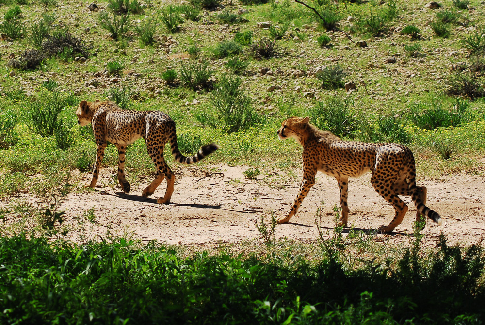
Mother cheetah at Rooiputs
Morning was drawing on, and we were getting hungry, so we turned back towards Twee Rivieren, passing the lion pride again (still comatose).  We realized that there was a small track parallel to the main road, so we turned onto it in search of the cheetahs.  This was a lucky decision as, not far from where we had seen them before, right on the track in front of us were the cheetahs, lounging in the shade.  We edged as close as we dared without scaring them, turned off the engine and watched from a distance of maybe three metres.  The mother was magnificent, and the two cubs, almost fully grown, were equally impressive.  We sat there, barely daring to breathe, unwilling to have the spell broken.  Fifty metres away, on the main road, two or three vehicles stopped to watch the cheetahs through binoculars, but luckily nobody figured out how to get onto our little track, and we had our close encounter all to ourselves.  I snapped away madly, then just sat and watched, mesmerized and unable to believe our good luck.

Sub-adult cheetahs near Rooiputs
Leopard tortoise nibbling at the sand on the jeep track
Eventually the mother got interested in some springbok that were not too far away.  Her ears perked up, she sat up and then remained motionless, staring at the prey.  We hoped that she would suddenly explode into pursuit, but after a while she sauntered off towards the Rooiputs waterhole followed by her two daughters, all of them the picture of elegance, their pelts shining in the sun.  We drove off back towards Twee Rivieren ecstatic:  cheetahs at last, and so close to us!  The drive back brought us more ostriches (not babies this time, sadly), gemsbok, several falcons of various species, more jackals and finally a secretarybird, one of our all-time favourite birds.  We arrived back at camp thoroughly satisfied with our morning's work.

Springbok mothers and child
A lazy afternoon by the pool followed, along with sorting through hundreds of photos from one of our best game-viewing mornings of the entire trip.  We braaied up more delicious boerewors that night.  Our sleep was interrupted that night several times by the unmistakeable sound of lions roaring. We woke up determined to find them, and another early-morning getaway after an unforgettable red sunrise, we soon found the lions.  For once, since we were so early, we were the first on the scene, and we were pleased to have spotted the lions for ourselves.  It was a big pride, with no fewer than nine lions, including three large males.  They weren't doing much, but their size was impressive, and it was fun trying to spot more and more of them scattered throughout the bush; we saw only three at first, but one by one the others revealed themselves.

Ostriches on patrol in the Kgalagadi Transfrontier Park
We had a profusion of leopard tortoises that morning, along with numerous kori bustards (including one very impressive displaying male that was so puffed up that we couldn't recognize it at first as a kori).  There were big nursery day-care groups of springbok babies teetering on their matchstick legs (which would doubtless make great cheetah food), more gemsbok running off up the dunes, a few sturdy-looking hartebeest and lots of ostriches.  We struck out on cheetah, but after yesterday's encounter, we weren't complaining.

Gemsbok (oryx) fleeing at our approach
Hartebeest near Twee Rivieren
By 10:00 am we were back at camp, buying a few supplies in the camp store, eating pies and planning our escape from the country.  It was Sunday, January 22nd and we had been in South Africa proper for a little more than three weeks, racking up a ridiculous 6000 km in that time despite missing much of what we had originally planned to see.  (In contrast, it took us five and a half months to do our first 20,000 km.) It hadn't turned out at all as we had originally thought, but our time at Leeupan and in the Kgalagadi Transfrontier Park had made up for our frustrations with the rainy weather and mechanical gremlins that had plagued us earlier.  We had enjoyed South Africa, but now it was time to turn our sights towards everyone's favourite country to visit in southern Africa:  Namibia.


Male kori bustard puffed up and displaying
It was an easy drive to the border at Rietfontein, across a landscape that was surprisingly dramatic. We crossed a couple of big, wide-open pans, one of them full of water after the recent rains.  By 1:00 pm we were going through border formalities and driving into Namibia, my 132nd country and Terri's 78th.

Lion cub resting in the shade near Twee Rivieren